Porcupine Creek River Run
Community Reviews
Been here? Share the conditions.
Reviews, ratings & photos are added in the free Snoflo iOS app — rate a spot, tag the conditions, and your visit is verified by location. Add or manage your reviews from the app.
Porcupine Creek
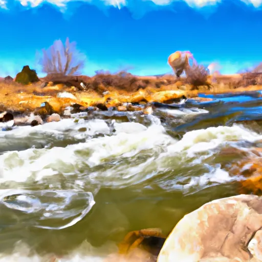
Porcupine Creek is rated as a class II to III river, meaning that it has moderate rapids and currents that require some skill and experience to navigate safely. The segment mileage of this river run is approximately 13 miles, and it is known for its scenic views and challenging rapids.
Some of the specific rapids and obstacles on Porcupine Creek include Big Bend, a sharp turn that requires precise maneuvering, and Little Falls, a series of small drops that can be challenging for beginner paddlers. Other notable features of this river run include narrow channels and tight turns that add to the excitement of the ride.
In terms of regulations, Porcupine Creek is located within the Bridger-Teton National Forest and is subject to certain rules and restrictions. For example, visitors are required to have a valid permit to access the river, and motorized vehicles are not allowed in the area. Additionally, visitors are encouraged to practice Leave No Trace principles to help protect the natural environment.
Overall, Porcupine Creek is a popular whitewater river run that offers a fun and challenging experience for experienced paddlers. With its scenic views, challenging rapids, and specific regulations, it is a great destination for anyone looking to explore the great outdoors in Wyoming.
Plan your run down to the hour
Same weather feed Snoflo's iOS app uses -- updated continuously from NOAA / yr.no. Watch the precipitation column on the meteogram; rain ahead of a run typically lifts flows 12-48 hours later depending on the basin.
Next 5 days, hour by hour
Temperature line with weather symbols on top, snow + rain accumulation as columns, humidity as a dotted line.
5-day forecast table
Every 3 hours, broken out across temperature, snow, rain, humidity, and wind. Each cell is colour-coded relative to the column min/max.
| Time | Condition | Temp (°F) | Snow (in) | Rain (in) | Humidity (%) | Wind (mps) | Wind dir |
|---|---|---|---|---|---|---|---|
| Loading detailed forecast… | |||||||
15-day temperature & precipitation
Daily temperatures, snow, and rain projected over the next two weeks -- the upstream story that drives next week's flows.
Regional streamflow levels
USGS streamgauges around Porcupine Creek -- useful for spotting upstream pulses and gauging which tributary is contributing what.
| Streamgauge | Discharge | View |
|---|---|---|
| Bighorn River At Kane | 736 cfs | → |
| Shoshone River Near Lovell | 657 cfs | → |
| Little Bighorn River At State Line Nr Wyola Mt | 84 cfs | → |
| Bighorn River Near St. Xavier | 1,600 cfs | → |
| West Pass Creek Near Parkman | 10 cfs | → |
| Shell Creek Near Shell | 74 cfs | → |
Plan a longer trip
The closest boat launches, other paddle runs, and campgrounds so a day on the water can grow into a full weekend.
Campgrounds
- Cottonwood Creek Campsite 3
- Cottonwood Creek Campsite 4
- Cottonwood Creek Campsite 2
- Cottonwood Creek Campsite 1
- Cottonwood Creek Campsite 5
- Cottonwood Creek Campground
Whitewater safety
- Check the flow before you run
- Use the linked-gauge card and Regional Flow panel above. Class ratings change with flow -- a Class III at low water can become Class IV+ at high water.
- Know your skill ceiling
- Pick runs comfortably below your ceiling. Cold-water and big-water runs raise the consequences of any mistake.
- Wear the right gear
- Helmet, PFD, drysuit / wetsuit when water is below 60°F. Throw bag, knife, and whistle on your person, not in the boat.
- Scout, set safety, and run with a team
- Scout new rapids on foot, set safety with throw bags above the consequence pool, and run with at least one other competent paddler.
- Respect the river
- Strainers, undercuts, low-head dams, and wood can kill at any class rating. When in doubt, portage.
Set push alerts in the Snoflo app
Save Porcupine Creek as a favorite, set a discharge threshold (e.g. "alert me when flow hits 600 cfs"), and the iOS app pushes the moment the linked gauge crosses.
About Porcupine Creek
What's the optimal flow for Porcupine Creek?
The optimal flow depends on the section and the craft. Check the Run Details panel for the linked gauge and current status.
How fresh is the cfs reading on this page?
The linked USGS streamgauge reports continuously (every 15 minutes); Snoflo refreshes throughout the day. Hover the streamflow sparkline to read individual datapoints.
What's the whitewater class?
See the Run Details panel for the class rating Snoflo tracks for this run. Class ratings change with flow -- a Class III at low water can become Class IV in high water.
Where do I put in / take out?
Tap Directions in the hero above to open driving directions to the put-in. For shuttle planning, check the Nearby Boat Launches panel and the river run operator's site.
Can I get alerts when flows hit the optimal range?
Yes -- alerts are managed in the Snoflo iOS app. Favorite this run, set a discharge threshold, and you'll get a push the moment the gauge crosses.
Other runs near here
Snoflo-tracked paddle runs within driving distance of Porcupine Creek.