Porcupine Creek River Run
Community Reviews
Been here? Share the conditions.
Reviews, ratings & photos are added in the free Snoflo iOS app — rate a spot, tag the conditions, and your visit is verified by location. Add or manage your reviews from the app.
Porcupine Creek
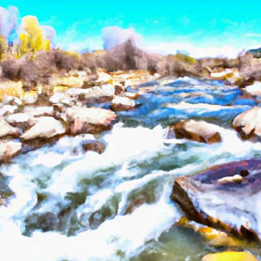
The run covers approximately 10 miles, with the first four miles being the most challenging. This section includes steep drops, tight chutes, and technical rapids such as Pinball and the Notch. The remaining six miles are less challenging, with Class II-III rapids.
One of the most significant obstacles on Porcupine Creek is the Notch, a narrow slot that requires precise navigation through a series of technical moves. Other notable rapids on the run include Pinball, Double Drop, and the Flume.
The Shoshone National Forest manages the area, and visitors are required to adhere to specific regulations. A permit is necessary to access the river, and visitors must follow Leave No Trace principles. Additionally, visitors must pack out all trash and avoid camping within 200 feet of the water.
In summary, Porcupine Creek is a challenging Class III-V whitewater run in Wyoming that demands experience and skill from paddlers. The ideal streamflow range is between 800 and 2,000 cfs, and the run covers approximately 10 miles. The most challenging section is the first four miles, which includes technical rapids like Pinball and the Notch. Visitors must adhere to specific regulations, including obtaining a permit and adhering to Leave No Trace principles.
Plan your run down to the hour
Same weather feed Snoflo's iOS app uses -- updated continuously from NOAA / yr.no. Watch the precipitation column on the meteogram; rain ahead of a run typically lifts flows 12-48 hours later depending on the basin.
Next 5 days, hour by hour
Temperature line with weather symbols on top, snow + rain accumulation as columns, humidity as a dotted line.
5-day forecast table
Every 3 hours, broken out across temperature, snow, rain, humidity, and wind. Each cell is colour-coded relative to the column min/max.
| Time | Condition | Temp (°F) | Snow (in) | Rain (in) | Humidity (%) | Wind (mps) | Wind dir |
|---|---|---|---|---|---|---|---|
| Loading detailed forecast… | |||||||
15-day temperature & precipitation
Daily temperatures, snow, and rain projected over the next two weeks -- the upstream story that drives next week's flows.
Regional streamflow levels
USGS streamgauges around Porcupine Creek -- useful for spotting upstream pulses and gauging which tributary is contributing what.
| Streamgauge | Discharge | View |
|---|---|---|
| Bighorn River At Kane | 736 cfs | → |
| Shoshone River Near Lovell | 657 cfs | → |
| Little Bighorn River At State Line Nr Wyola Mt | 84 cfs | → |
| Bighorn River Near St. Xavier | 1,600 cfs | → |
| West Pass Creek Near Parkman | 10 cfs | → |
| East Pass Creek Near Dayton | 12 cfs | → |
Plan a longer trip
The closest boat launches, other paddle runs, and campgrounds so a day on the water can grow into a full weekend.
Campgrounds
- Full Hook-Up Campsite
- Horseshoe Bend Campground
- Horseshoe Bend - Bighorn Canyon National Rec Area
- Cottonwood Creek Campsite 3
- Cottonwood Creek Campsite 4
- Cottonwood Creek Campsite 2
Whitewater safety
- Check the flow before you run
- Use the linked-gauge card and Regional Flow panel above. Class ratings change with flow -- a Class III at low water can become Class IV+ at high water.
- Know your skill ceiling
- Pick runs comfortably below your ceiling. Cold-water and big-water runs raise the consequences of any mistake.
- Wear the right gear
- Helmet, PFD, drysuit / wetsuit when water is below 60°F. Throw bag, knife, and whistle on your person, not in the boat.
- Scout, set safety, and run with a team
- Scout new rapids on foot, set safety with throw bags above the consequence pool, and run with at least one other competent paddler.
- Respect the river
- Strainers, undercuts, low-head dams, and wood can kill at any class rating. When in doubt, portage.
Set push alerts in the Snoflo app
Save Porcupine Creek as a favorite, set a discharge threshold (e.g. "alert me when flow hits 600 cfs"), and the iOS app pushes the moment the linked gauge crosses.
About Porcupine Creek
What's the optimal flow for Porcupine Creek?
The optimal flow depends on the section and the craft. Check the Run Details panel for the linked gauge and current status.
How fresh is the cfs reading on this page?
The linked USGS streamgauge reports continuously (every 15 minutes); Snoflo refreshes throughout the day. Hover the streamflow sparkline to read individual datapoints.
What's the whitewater class?
See the Run Details panel for the class rating Snoflo tracks for this run. Class ratings change with flow -- a Class III at low water can become Class IV in high water.
Where do I put in / take out?
Tap Directions in the hero above to open driving directions to the put-in. For shuttle planning, check the Nearby Boat Launches panel and the river run operator's site.
Can I get alerts when flows hit the optimal range?
Yes -- alerts are managed in the Snoflo iOS app. Favorite this run, set a discharge threshold, and you'll get a push the moment the gauge crosses.
Other runs near here
Snoflo-tracked paddle runs within driving distance of Porcupine Creek.