Community Reviews
Been here? Share the conditions.
Reviews, ratings & photos are added in the free Snoflo iOS app — rate a spot, tag the conditions, and your visit is verified by location. Add or manage your reviews from the app.
State Hospital Grounds
Reasons to Visit:
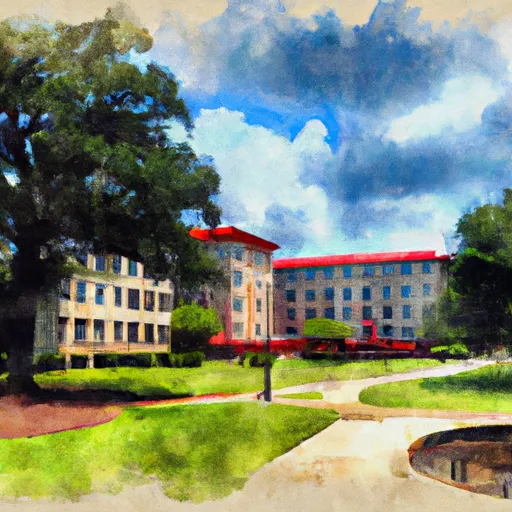
1. Historical Significance: The State Hospital Grounds provide a glimpse into the history of mental health care in Alabama, as it was the first state mental institution in the state.
2. Architecture: The grounds boast an impressive architectural style, reflecting both the historic and modern developments of mental health care facilities.
3. Natural Beauty: Visitors can enjoy the tranquil and well-maintained gardens, walking paths, and serene landscapes that surround the hospital grounds.
Points of Interest:
1. Bryce Hospital: The most prominent feature of the State Hospital Grounds is the Bryce Hospital, a significant example of Greek Revival architecture. It is recognized as a National Historic Landmark.
2. The Gazebo: Located on the grounds, the gazebo offers a picturesque setting amid beautiful gardens and serves as a popular spot for photography and relaxation.
3. The Superintendent's Cottage: A charming cottage on the premises, this building showcases historical features and provides insight into the past management of the hospital.
Interesting Facts:
1. Historic Role: The State Hospital Grounds, established in 1861, played a crucial role in the development of mental health care in Alabama, providing treatment to patients for over a century.
2. Name Change: In 2012, the official name of the hospital was changed from Bryce Hospital to the Alabama Department of Mental Health - Taylor Hardin Secure Medical Facility.
Best Time to Visit:
The best time to visit the State Hospital Grounds is during the mild seasons of spring (April to May) and fall (September to October) when temperatures are pleasant and the gardens are in full bloom. It is advisable to check the visiting hours and guidelines in advance, as the grounds may have specific visiting restrictions or designated tour times.
It is important to note that due to the sensitive nature of mental health care and the hospital's status as an active treatment facility, visitors should respect the privacy and regulations set by the authorities.
Plan your visit down to the hour
Same weather feed Snoflo's iOS app uses -- updated continuously from NOAA / yr.no.
Next 5 days, hour by hour
Temperature line with weather symbols on top, snow + rain accumulation as columns, humidity as a dotted line.
5-day forecast table
Every 3 hours, broken out across temperature, snow, rain, humidity, and wind.
| Time | Condition | Temp (°F) | Snow (in) | Rain (in) | Humidity (%) | Wind (mps) | Wind dir |
|---|---|---|---|---|---|---|---|
| Loading detailed forecast… | |||||||
15-day temperature & precipitation
Daily temperatures, snow, and rain projected over the next two weeks.
Responsible recreation & Leave No Trace
- Know before you go
- Check the operator's site for hours, permit requirements, seasonal closures, and fire restrictions before heading out.
- Stay on trail
- Stick to marked paths to protect vegetation, prevent erosion, and avoid disturbing wildlife habitat.
- Respect wildlife
- Observe from a distance, never feed wildlife, and store food securely if camping is permitted on-site.
- Pack it in, pack it out
- Carry out all trash, food scraps, and gear. Many parks have limited or no trash service.
- Leave what you find
- Don't take rocks, plants, or artifacts. They make the park what it is for the next visitor.
Set push alerts in the Snoflo app
Save State Hospital Grounds as a favorite, set a custom threshold (precipitation, freezing temperatures, fire-restriction days), and the iOS app will push the moment conditions cross.
About State Hospital Grounds
What can I do at State Hospital Grounds?
Most Snoflo-tracked parks support hiking, picnicking, and wildlife viewing. Check the operator's site for activity-specific rules (camping, fishing, paddling, hunting).
How fresh is the weather data?
The hourly forecast updates throughout the day from NOAA / yr.no. Streamflow comes live from USGS streamgauges.
When is the best time to visit?
Use the 15-day temperature & precipitation outlook on this page to plan -- pick a window with comfortable temperatures and low precipitation.
How do I get to State Hospital Grounds?
Tap Directions in the hero above to open driving directions in Google Maps, or Open in map to center the Snoflo interactive map on the park.
Can I get alerts when conditions change?
Yes -- alerts are managed in the Snoflo iOS app. Favorite this park, set a threshold (temperature, precipitation), and you'll get a push the moment it crosses.
Park & land designation reference
A quick legend for the federal and state land categories Snoflo tracks. Each designation comes with different rules around access, recreation, and resource extraction.
- National Park
- Large protected natural areas managed by the federal government to preserve significant landscapes, ecosystems, and cultural resources; recreation is allowed but conservation is the priority.
- State Park
- Public natural or recreational areas managed by a state government, typically smaller than national parks and focused on regional natural features, recreation, and education.
- Local Park
- Community-level parks managed by cities or counties, emphasizing recreation, playgrounds, sports, and green space close to populated areas.
- Wilderness Area
- The highest level of land protection in the U.S.; designated areas where nature is left essentially untouched, with no roads, structures, or motorized motorized access permitted.
- National Recreation Area
- Areas set aside primarily for outdoor recreation (boating, hiking, fishing, often around reservoirs, rivers, or scenic landscapes); may allow more development.
- National Conservation Area (BLM)
- BLM-managed areas with special ecological, cultural, or scientific value; more protection than typical BLM land but less strict than Wilderness Areas.
- State Forest
- State-managed forests focused on habitat, watershed, recreation, and sustainable timber harvest.
- Bureau of Land Management (BLM) Land
- Vast federal lands managed for mixed use -- recreation, grazing, mining, conservation -- with fewer restrictions than national parks or forests.