Tuzigoot National Monument
Community Reviews
Been here? Share the conditions.
Reviews, ratings & photos are added in the free Snoflo iOS app — rate a spot, tag the conditions, and your visit is verified by location. Add or manage your reviews from the app.
Tuzigoot National Monument
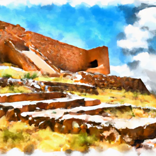
One of the main attractions at Tuzigoot National Monument is the Tuzigoot Pueblo, a well-preserved pueblo ruin that stands atop a hill. The pueblo consists of a cluster of rooms, including living quarters and communal spaces, built primarily from stone and clay. Exploring the pueblo provides a fascinating insight into the daily lives and activities of the Sinagua people, who occupied the site between the 12th and 15th centuries.
Besides the pueblo, visitors can also explore the museum located on the premises. The museum showcases an extensive collection of artifacts found at Tuzigoot, which helps visitors better understand the history and culture of the Sinagua people. Exhibits include pottery, tools, jewelry, and other artifacts that were crucial to the Sinagua's way of life.
Tuzigoot National Monument is not only historically significant but also boasts stunning natural beauty. The monument is situated near the Verde River and offers panoramic views of the surrounding desert and mountains. Hiking trails within the monument allow visitors to experience the diverse flora and fauna of the area, including unique desert plants and wildlife.
Interesting facts about Tuzigoot National Monument include its designation as a national monument in 1939 by President Franklin D. Roosevelt. The name "Tuzigoot" is derived from the Apache word for "crooked water," referencing the nearby Verde River. The Sinagua people, known for their agricultural practices, grew crops such as corn, beans, and squash, using an elaborate irrigation system.
The best time to visit Tuzigoot National Monument is during the fall, winter, and spring months when the weather is mild and comfortable for outdoor exploration. Summers can be extremely hot, so visiting during the cooler seasons is recommended.
To ensure accuracy, it is advisable to verify the information provided by cross-referencing multiple independent sources such as the official National Park Service website, reputable travel guides, and scholarly articles on Tuzigoot National Monument.
Points of interest in Tuzigoot National Monument
Landmarks and points of interest inside the park boundary.


Plan your visit down to the hour
Same weather feed Snoflo's iOS app uses -- updated continuously from NOAA / yr.no.
Next 5 days, hour by hour
Temperature line with weather symbols on top, snow + rain accumulation as columns, humidity as a dotted line.
5-day forecast table
Every 3 hours, broken out across temperature, snow, rain, humidity, and wind.
| Time | Condition | Temp (°F) | Snow (in) | Rain (in) | Humidity (%) | Wind (mps) | Wind dir |
|---|---|---|---|---|---|---|---|
| Loading detailed forecast… | |||||||
15-day temperature & precipitation
Daily temperatures, snow, and rain projected over the next two weeks.
Responsible recreation & Leave No Trace
- Know before you go
- Check the operator's site for hours, permit requirements, seasonal closures, and fire restrictions before heading out.
- Stay on trail
- Stick to marked paths to protect vegetation, prevent erosion, and avoid disturbing wildlife habitat.
- Respect wildlife
- Observe from a distance, never feed wildlife, and store food securely if camping is permitted on-site.
- Pack it in, pack it out
- Carry out all trash, food scraps, and gear. Many parks have limited or no trash service.
- Leave what you find
- Don't take rocks, plants, or artifacts. They make the park what it is for the next visitor.
Set push alerts in the Snoflo app
Save Tuzigoot National Monument as a favorite, set a custom threshold (precipitation, freezing temperatures, fire-restriction days), and the iOS app will push the moment conditions cross.
About Tuzigoot National Monument
What can I do at Tuzigoot National Monument?
Most Snoflo-tracked parks support hiking, picnicking, and wildlife viewing. Check the operator's site for activity-specific rules (camping, fishing, paddling, hunting).
How fresh is the weather data?
The hourly forecast updates throughout the day from NOAA / yr.no. Streamflow comes live from USGS streamgauges.
When is the best time to visit?
Use the 15-day temperature & precipitation outlook on this page to plan -- pick a window with comfortable temperatures and low precipitation.
How do I get to Tuzigoot National Monument?
Tap Directions in the hero above to open driving directions in Google Maps, or Open in map to center the Snoflo interactive map on the park.
Can I get alerts when conditions change?
Yes -- alerts are managed in the Snoflo iOS app. Favorite this park, set a threshold (temperature, precipitation), and you'll get a push the moment it crosses.
Park & land designation reference
A quick legend for the federal and state land categories Snoflo tracks. Each designation comes with different rules around access, recreation, and resource extraction.
- National Park
- Large protected natural areas managed by the federal government to preserve significant landscapes, ecosystems, and cultural resources; recreation is allowed but conservation is the priority.
- State Park
- Public natural or recreational areas managed by a state government, typically smaller than national parks and focused on regional natural features, recreation, and education.
- Local Park
- Community-level parks managed by cities or counties, emphasizing recreation, playgrounds, sports, and green space close to populated areas.
- Wilderness Area
- The highest level of land protection in the U.S.; designated areas where nature is left essentially untouched, with no roads, structures, or motorized motorized access permitted.
- National Recreation Area
- Areas set aside primarily for outdoor recreation (boating, hiking, fishing, often around reservoirs, rivers, or scenic landscapes); may allow more development.
- National Conservation Area (BLM)
- BLM-managed areas with special ecological, cultural, or scientific value; more protection than typical BLM land but less strict than Wilderness Areas.
- State Forest
- State-managed forests focused on habitat, watershed, recreation, and sustainable timber harvest.
- Bureau of Land Management (BLM) Land
- Vast federal lands managed for mixed use -- recreation, grazing, mining, conservation -- with fewer restrictions than national parks or forests.