Round Island Wilderness
Community Reviews
Been here? Share the conditions.
Reviews, ratings & photos are added in the free Snoflo iOS app — rate a spot, tag the conditions, and your visit is verified by location. Add or manage your reviews from the app.

Round Island Wilderness
There are several compelling reasons to visit Round Island Wilderness. Firstly, its remote location provides a sense of tranquility and solitude that is hard to find in more populated areas. This makes it an ideal destination for those seeking a peaceful getaway surrounded by nature. Additionally, the island's diverse ecosystems, including forests, wetlands, and coastal areas, offer opportunities for various outdoor activities such as hiking, birdwatching, and photography.
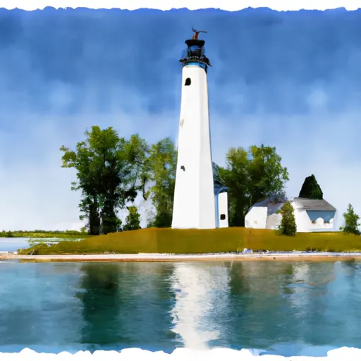
One of the main points of interest on Round Island is the Round Island Lighthouse. Built in 1895, this historic lighthouse played a significant role in guiding ships through the treacherous waters of the Straits of Mackinac. Although the lighthouse is not open to the public, visitors can enjoy viewing it from the shoreline or from boat tours around the island.
Round Island is also home to a variety of wildlife species, including bald eagles, ospreys, white-tailed deer, and various migratory birds. Animal lovers and nature enthusiasts will appreciate the opportunity to observe and appreciate these creatures in their natural habitats.
Interesting facts about Round Island Wilderness include its designation as a federally designated wilderness area, which means it is protected and preserved in its natural state. This designation ensures that the island remains undeveloped and allows visitors to experience the unspoiled beauty of the area. Additionally, Round Island is known for its unique geological features, such as limestone formations and caves, which provide a glimpse into the island's ancient history.
The best time of year to visit Round Island Wilderness is during the summer months, from June to September, when the weather is generally mild and favorable for outdoor activities. However, it is important to note that the island is only accessible by private boat or by booking a tour, so it is advisable to plan transportation in advance. It is recommended to check with local authorities or visit the official Hiawatha National Forest website for up-to-date information on accessibility and visitor regulations.
To ensure accuracy, it is always recommended to verify the information from multiple independent sources, such as the official Hiawatha National Forest website, Michigan state tourism websites, and reputable travel guides.
Points of interest in Round Island Wilderness
Landmarks and points of interest inside the park boundary.
Plan your visit down to the hour
Same weather feed Snoflo's iOS app uses -- updated continuously from NOAA / yr.no.
Next 5 days, hour by hour
Temperature line with weather symbols on top, snow + rain accumulation as columns, humidity as a dotted line.
5-day forecast table
Every 3 hours, broken out across temperature, snow, rain, humidity, and wind.
| Time | Condition | Temp (°F) | Snow (in) | Rain (in) | Humidity (%) | Wind (mps) | Wind dir |
|---|---|---|---|---|---|---|---|
| Loading detailed forecast… | |||||||
15-day temperature & precipitation
Daily temperatures, snow, and rain projected over the next two weeks.
Responsible recreation & Leave No Trace
- Know before you go
- Check the operator's site for hours, permit requirements, seasonal closures, and fire restrictions before heading out.
- Stay on trail
- Stick to marked paths to protect vegetation, prevent erosion, and avoid disturbing wildlife habitat.
- Respect wildlife
- Observe from a distance, never feed wildlife, and store food securely if camping is permitted on-site.
- Pack it in, pack it out
- Carry out all trash, food scraps, and gear. Many parks have limited or no trash service.
- Leave what you find
- Don't take rocks, plants, or artifacts. They make the park what it is for the next visitor.
Set push alerts in the Snoflo app
Save Round Island Wilderness as a favorite, set a custom threshold (precipitation, freezing temperatures, fire-restriction days), and the iOS app will push the moment conditions cross.
About Round Island Wilderness
What can I do at Round Island Wilderness?
Most Snoflo-tracked parks support hiking, picnicking, and wildlife viewing. Check the operator's site for activity-specific rules (camping, fishing, paddling, hunting).
How fresh is the weather data?
The hourly forecast updates throughout the day from NOAA / yr.no. Streamflow comes live from USGS streamgauges.
When is the best time to visit?
Use the 15-day temperature & precipitation outlook on this page to plan -- pick a window with comfortable temperatures and low precipitation.
How do I get to Round Island Wilderness?
Tap Directions in the hero above to open driving directions in Google Maps, or Open in map to center the Snoflo interactive map on the park.
Can I get alerts when conditions change?
Yes -- alerts are managed in the Snoflo iOS app. Favorite this park, set a threshold (temperature, precipitation), and you'll get a push the moment it crosses.
Park & land designation reference
A quick legend for the federal and state land categories Snoflo tracks. Each designation comes with different rules around access, recreation, and resource extraction.
- National Park
- Large protected natural areas managed by the federal government to preserve significant landscapes, ecosystems, and cultural resources; recreation is allowed but conservation is the priority.
- State Park
- Public natural or recreational areas managed by a state government, typically smaller than national parks and focused on regional natural features, recreation, and education.
- Local Park
- Community-level parks managed by cities or counties, emphasizing recreation, playgrounds, sports, and green space close to populated areas.
- Wilderness Area
- The highest level of land protection in the U.S.; designated areas where nature is left essentially untouched, with no roads, structures, or motorized motorized access permitted.
- National Recreation Area
- Areas set aside primarily for outdoor recreation (boating, hiking, fishing, often around reservoirs, rivers, or scenic landscapes); may allow more development.
- National Conservation Area (BLM)
- BLM-managed areas with special ecological, cultural, or scientific value; more protection than typical BLM land but less strict than Wilderness Areas.
- State Forest
- State-managed forests focused on habitat, watershed, recreation, and sustainable timber harvest.
- Bureau of Land Management (BLM) Land
- Vast federal lands managed for mixed use -- recreation, grazing, mining, conservation -- with fewer restrictions than national parks or forests.