Round Island Lighthouse Overview
Community Reviews
Been here? Share the conditions.
Reviews, ratings & photos are added in the free Snoflo iOS app — rate a spot, tag the conditions, and your visit is verified by location. Add or manage your reviews from the app.
Round Island Lighthouse
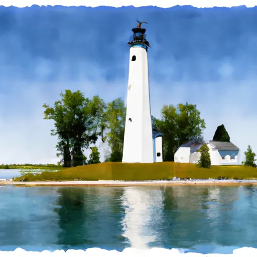
<p><strong>New! </strong><em>Take a self-guided tour of our Lighthouses via the Hiawatha's OnCell App! Learn more <a href="https://www.fs.usda.gov/detail/hiawatha/news-events/?cid=FSEPRD647335">here</a>.</em></p><p>The lighthouse is located on a sand and cobblestone spit extending from Round Island into the narrow channel between Round Island and Mackinac Island. It was built in 1895 at a cost of $15,000 under the supervision of Frank Rounds from Detroit. Frank originally came to the Straits area to help build the Grand Hotel on Mackinac Island. It was commissioned on May 15, 1896 under the U.S. Lighthouse Board which became the United States Lighthouse Service in 1910. In 1924 the beacon was automated and the United States Coast Guard was given responsibility for all lighthouses in 1939. The lighthouse was deactivated in 1947, and transferred to the United States Forest Service in 1958. The beacon has gone through several changes of lighting technology, from oil to electricity. It originally had a 4th order Fresnel lens with a steady white light followed by a red flash every 20 seconds. Today it is powered by the sun using solar cells and storage batteries. On the first floor, most of the original machinery for operation of the lighthouse and foghorn were removed for scrap to support World War II efforts. The second and third floors provided living quarters for the lighthouse keepers and their families during the shipping season.</p><p>The Forest Service has a unique partnership to assist with maintenance and upkeep of the lighthouse and out buildings. The Round Island Lighthouse Preservation Society is a Michigan non-profit corporation, founded solely to assist with facilitating the preservation of the Round Island Lighthouse and grounds. In addition, the Lake Huron Area Council Boy Scout Troop 323 of Freeland, Michigan also assists with summer clean-up activities and repairs. </p><p>If you are interested in learning more about the Round Island Lighthouse, please call the Saint Ignace office of the Hiawatha National Forest or visit our partner’s website at: <a href="http://www.roundislandlightmichigan.com/">http://www.roundislandlightmichigan.com/</a></p><h2>See for yourself</h2><div style="padding:56.25% 0 0 0;position:relative;"><iframe src="https://player.vimeo.com/video/747419191?h=52cc162cc5&badge=0&autopause=0&player_id=0&app_id=58479" frameborder="0" allow="autoplay; fullscreen; picture-in-picture" allowfullscreen style="position:absolute;top:0;left:0;width:100%;height:100%;" title="Round Island Lighthouse"></iframe></div><script src="https://player.vimeo.com/api/player.js"></script>
Plan your visit down to the hour
Same weather feed Snoflo's iOS app uses -- updated continuously from NOAA / yr.no.
Next 5 days, hour by hour
Temperature line with weather symbols on top, snow + rain accumulation as columns, humidity as a dotted line.
5-day forecast table
Every 3 hours, broken out across temperature, snow, rain, humidity, and wind.
| Time | Condition | Temp (°F) | Snow (in) | Rain (in) | Humidity (%) | Wind (mps) | Wind dir |
|---|---|---|---|---|---|---|---|
| Loading detailed forecast… | |||||||
15-day temperature & precipitation
Daily temperatures, snow, and rain projected over the next two weeks.
Plan a longer trip
The closest parks, campgrounds, fishing spots, and other landmarks so a quick visit can grow into a full day.
Parks
- Mackinac Island State Park
- Fort Mackinac State Historic Site
- Fort Holmes State Historic Site
- Round Island Wilderness
- Straits State Park
- Father Marquette National Memorial
Campgrounds
- Straits State Park Semi Modern Waterfront
- Straits State Park
- Tiki Rv Park & Campground
- Cecil Lakeview City Park
- Carp River Campground
- Carp River
Fishing spots
Responsible visitation & Leave No Trace
- Know before you go
- Check the operator's site (BLM, NPS, state agency, or private owner) for access rules, permits, and seasonal closures before driving out.
- Stay on trail
- Many points of interest sit in fragile ecosystems. Stick to marked paths to protect vegetation and prevent erosion.
- Respect wildlife
- Observe from a distance, never feed wildlife, and give nesting birds and denning mammals plenty of space.
- Pack it in, pack it out
- Take all trash, food scraps, and gear back with you. Remote sites often have no trash service.
- Leave what you find
- Don't take rocks, plants, fossils, or artifacts. Federal law protects cultural and natural resources on public land.
Set push alerts in the Snoflo app
Save Round Island Lighthouse as a favorite, set a weather threshold (precipitation, freezing temperatures), and the iOS app will push the moment conditions cross.
About Round Island Lighthouse
What is Round Island Lighthouse?
A point of interest in Michigan tracked by Snoflo -- typically a scenic landmark, named summit, monument, or viewpoint.
How fresh is the weather data?
The hourly forecast updates throughout the day from NOAA / yr.no public feeds.
When is the best time to visit?
Use the 15-day temperature & precipitation outlook on this page to pick a window with comfortable temperatures and low precipitation.
How do I get there?
Tap Directions in the hero above for Google Maps driving directions, or Open in map to center the Snoflo interactive map on the spot.
Can I get alerts when conditions change?
Yes -- alerts are managed in the Snoflo iOS app. Favorite this POI, set a threshold (temperature, precipitation), and you'll get a push the moment it crosses.
Other points of interest near here
Snoflo-tracked landmarks within driving distance of Round Island Lighthouse.