Community Reviews
Been here? Share the conditions.
Reviews, ratings & photos are added in the free Snoflo iOS app — rate a spot, tag the conditions, and your visit is verified by location. Add or manage your reviews from the app.
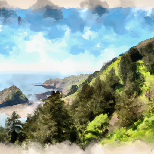
Viento State Park
One of the primary reasons to visit Viento State Park is its stunning natural setting. Surrounded by lush forests and nestled alongside the powerful Columbia River, the park provides a serene and scenic escape for nature enthusiasts. Its diverse ecosystem supports a wide array of wildlife, making it a popular spot for bird-watching and wildlife observation.
Within Viento State Park, there are several points of interest that make the visit even more worthwhile. The park features a well-maintained campground, providing opportunities for overnight stays amidst the gorgeous surroundings. Additionally, visitors can enjoy picnicking, hiking, and biking along the park's well-marked trails.
One particularly fascinating aspect of Viento State Park is its historical significance. The park lies along the historic Columbia River Highway, which was the first scenic highway in the United States. Travelers can still see remnants of the original highway, including historic bridges and tunnels. This makes Viento State Park a great destination for history buffs and those interested in early 20th-century engineering.
If you plan to visit Viento State Park, it is essential to consider the best time of year to maximize your experience. The park is known for its temperate climate, but the weather can vary throughout the year. Generally, the best time to visit is during the spring and summer months, from April to September. During this time, the weather is typically mild, and the park is at its most vibrant, with blooming wildflowers and lush foliage.
In conclusion, Viento State Park in Oregon is a captivating destination offering numerous reasons to visit. Its stunning natural beauty, diverse wildlife, well-maintained trails, and historical significance make it an ideal location for outdoor enthusiasts and history lovers alike. By visiting during the spring and summer months, you can fully appreciate the park's beauty and enjoy the range of activities it has to offer.
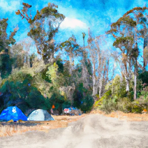
Camping in Viento State Park
Campgrounds inside the park, with today's conditions score.
Plan your visit down to the hour
Same weather feed Snoflo's iOS app uses -- updated continuously from NOAA / yr.no.
Next 5 days, hour by hour
Temperature line with weather symbols on top, snow + rain accumulation as columns, humidity as a dotted line.
5-day forecast table
Every 3 hours, broken out across temperature, snow, rain, humidity, and wind.
| Time | Condition | Temp (°F) | Snow (in) | Rain (in) | Humidity (%) | Wind (mps) | Wind dir |
|---|---|---|---|---|---|---|---|
| Loading detailed forecast… | |||||||
15-day temperature & precipitation
Daily temperatures, snow, and rain projected over the next two weeks.
Responsible recreation & Leave No Trace
- Know before you go
- Check the operator's site for hours, permit requirements, seasonal closures, and fire restrictions before heading out.
- Stay on trail
- Stick to marked paths to protect vegetation, prevent erosion, and avoid disturbing wildlife habitat.
- Respect wildlife
- Observe from a distance, never feed wildlife, and store food securely if camping is permitted on-site.
- Pack it in, pack it out
- Carry out all trash, food scraps, and gear. Many parks have limited or no trash service.
- Leave what you find
- Don't take rocks, plants, or artifacts. They make the park what it is for the next visitor.
Set push alerts in the Snoflo app
Save Viento State Park as a favorite, set a custom threshold (precipitation, freezing temperatures, fire-restriction days), and the iOS app will push the moment conditions cross.
About Viento State Park
What can I do at Viento State Park?
Most Snoflo-tracked parks support hiking, picnicking, and wildlife viewing. Check the operator's site for activity-specific rules (camping, fishing, paddling, hunting).
How fresh is the weather data?
The hourly forecast updates throughout the day from NOAA / yr.no. Streamflow comes live from USGS streamgauges.
When is the best time to visit?
Use the 15-day temperature & precipitation outlook on this page to plan -- pick a window with comfortable temperatures and low precipitation.
How do I get to Viento State Park?
Tap Directions in the hero above to open driving directions in Google Maps, or Open in map to center the Snoflo interactive map on the park.
Can I get alerts when conditions change?
Yes -- alerts are managed in the Snoflo iOS app. Favorite this park, set a threshold (temperature, precipitation), and you'll get a push the moment it crosses.
Park & land designation reference
A quick legend for the federal and state land categories Snoflo tracks. Each designation comes with different rules around access, recreation, and resource extraction.
- National Park
- Large protected natural areas managed by the federal government to preserve significant landscapes, ecosystems, and cultural resources; recreation is allowed but conservation is the priority.
- State Park
- Public natural or recreational areas managed by a state government, typically smaller than national parks and focused on regional natural features, recreation, and education.
- Local Park
- Community-level parks managed by cities or counties, emphasizing recreation, playgrounds, sports, and green space close to populated areas.
- Wilderness Area
- The highest level of land protection in the U.S.; designated areas where nature is left essentially untouched, with no roads, structures, or motorized motorized access permitted.
- National Recreation Area
- Areas set aside primarily for outdoor recreation (boating, hiking, fishing, often around reservoirs, rivers, or scenic landscapes); may allow more development.
- National Conservation Area (BLM)
- BLM-managed areas with special ecological, cultural, or scientific value; more protection than typical BLM land but less strict than Wilderness Areas.
- State Forest
- State-managed forests focused on habitat, watershed, recreation, and sustainable timber harvest.
- Bureau of Land Management (BLM) Land
- Vast federal lands managed for mixed use -- recreation, grazing, mining, conservation -- with fewer restrictions than national parks or forests.