


Kanter Larsen Dam Reservoir Report
Last Updated: May 3, 2026
Nearby: Beasley Dam Waterman Dam 9775
°F
°F
mph
Wind
%
Humidity
Kanter Larsen Dam, located in Big Springs, Nebraska, is a privately owned structure designed by the USDA NRCS to serve multiple purposes, including flood risk reduction.
Summary
Completed in 1981, this earth dam stands at a height of 18 feet and has a hydraulic height of 16 feet, with a length of 1430 feet. With a maximum storage capacity of 195 acre-feet and a normal storage level of 12 acre-feet, this dam plays a crucial role in managing water resources in the area.
Operated and regulated by the Nebraska Department of Natural Resources, Kanter Larsen Dam has been deemed to have low hazard potential and was last inspected in May 2019, with a satisfactory condition assessment. The dam has a drainage area of 1.8 square miles and a maximum discharge capacity of 75 cubic feet per second. Despite its modest size, the dam provides vital protection against flooding for the surrounding community and supports the sustainable management of water resources in the region.
As an essential infrastructure for water management in Deuel County, Nebraska, Kanter Larsen Dam contributes to the overall resilience of the area against climate variability. With its efficient design and satisfactory condition, the dam serves as a testament to the importance of proactive measures in safeguarding our water resources and adapting to the challenges of a changing climate.
Regional Streamflow Levels
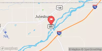 S. Platte R. At Julesburg
|
-999cfs |
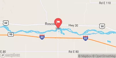 South Platte River At Roscoe Nebr
|
41cfs |
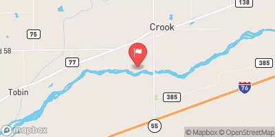 South Platte River Near Crook
|
13cfs |
15-Day Long Term Forecast
Year Completed |
1981 |
Dam Length |
1430 |
Dam Height |
18 |
River Or Stream |
TR-SOUTH PLATTE RIVER |
Primary Dam Type |
Earth |
Surface Area |
6 |
Hydraulic Height |
16 |
Drainage Area |
1.8 |
Nid Storage |
195 |
Structural Height |
18 |
Hazard Potential |
Low |
Foundations |
Soil |
Nid Height |
18 |
Seasonal Comparison
5-Day Hourly Forecast Detail
Dam Data Reference
Condition Assessment
SatisfactoryNo existing or potential dam safety deficiencies are recognized. Acceptable performance is expected under all loading conditions (static, hydrologic, seismic) in accordance with the minimum applicable state or federal regulatory criteria or tolerable risk guidelines.
Fair
No existing dam safety deficiencies are recognized for normal operating conditions. Rare or extreme hydrologic and/or seismic events may result in a dam safety deficiency. Risk may be in the range to take further action. Note: Rare or extreme event is defined by the regulatory agency based on their minimum
Poor A dam safety deficiency is recognized for normal operating conditions which may realistically occur. Remedial action is necessary. POOR may also be used when uncertainties exist as to critical analysis parameters which identify a potential dam safety deficiency. Investigations and studies are necessary.
Unsatisfactory
A dam safety deficiency is recognized that requires immediate or emergency remedial action for problem resolution.
Not Rated
The dam has not been inspected, is not under state or federal jurisdiction, or has been inspected but, for whatever reason, has not been rated.
Not Available
Dams for which the condition assessment is restricted to approved government users.
Hazard Potential Classification
HighDams assigned the high hazard potential classification are those where failure or mis-operation will probably cause loss of human life.
Significant
Dams assigned the significant hazard potential classification are those dams where failure or mis-operation results in no probable loss of human life but can cause economic loss, environment damage, disruption of lifeline facilities, or impact other concerns. Significant hazard potential classification dams are often located in predominantly rural or agricultural areas but could be in areas with population and significant infrastructure.
Low
Dams assigned the low hazard potential classification are those where failure or mis-operation results in no probable loss of human life and low economic and/or environmental losses. Losses are principally limited to the owner's property.
Undetermined
Dams for which a downstream hazard potential has not been designated or is not provided.
Not Available
Dams for which the downstream hazard potential is restricted to approved government users.
Area Campgrounds
| Location | Reservations | Toilets |
|---|---|---|
 Eagle Canyon
|
||
 Laveview
|
||
 Omaha Beach
|
||
 Otter Creek
|
||
 Spring Park
|
||
 Ogallala Beach Campground
|
 Goldeneye WMA
 Chappell Lake
 Humphrey Pond
 Jumbo Reservoir (Julesburg)
 Lodgepole Creek
 Jumbo Annex (Red Lion SWA)