


South Holston Dam Reservoir Report
Last Updated: April 27, 2026
°F
°F
mph
Wind
%
Humidity
South Holston Dam, located on the South Fork Holston River in Tennessee, is a remarkable structure designed by the Tennessee Valley Authority (TVA) with a primary purpose of flood risk reduction.
Summary
Completed in 1950, this rockfill dam stands at an impressive height of 285 feet and has a storage capacity of 890,367 acre-feet, making it a crucial element in managing water resources in the region.
Not only does South Holston Dam serve as a flood control measure, but it also supports hydroelectric power generation, recreational activities, and water supply for the surrounding areas. With a surface area of 7,600 acres and a drainage area of 703 square miles, the dam plays a significant role in regulating water flow and ensuring a balance in the ecosystem.
Despite its high hazard potential, South Holston Dam has been maintained by the Tennessee Valley Authority to ensure its structural integrity and safety. The dam's uncontrolled spillway, outlet gates, and various associated structures demonstrate the complexity of this critical infrastructure that continues to provide essential services while being a symbol of sustainable water resource management and climate resilience in the region.
Regional Streamflow Levels
 Beaver Creek At Bristol
|
22cfs |
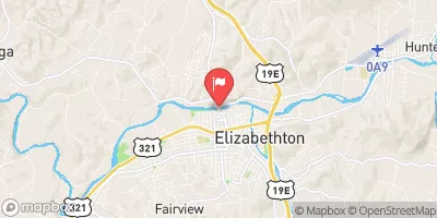 Watauga River At Elizabethton
|
378cfs |
 Doe River At Elizabethton
|
293cfs |
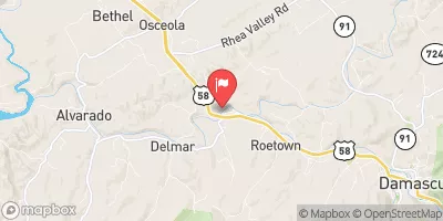 S F Holston River Near Damascus
|
182cfs |
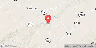 M F Holston River Near Meadowview
|
107cfs |
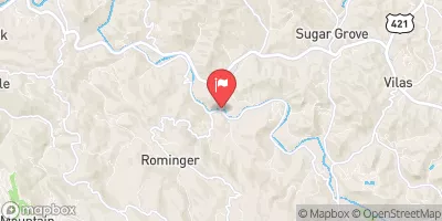 Watauga River Near Sugar Grove
|
65cfs |
15-Day Long Term Forecast
Year Completed |
1950 |
Dam Length |
1600 |
Dam Height |
285 |
River Or Stream |
SOUTH FORK HOLSTON RIVER |
Primary Dam Type |
Rockfill |
Surface Area |
7600 |
Hydraulic Height |
275 |
Drainage Area |
703 |
Nid Storage |
890367 |
Structural Height |
285 |
Outlet Gates |
Slide (sluice gate), Uncontrolled, Valve |
Hazard Potential |
High |
Foundations |
Rock |
Nid Height |
285 |
Seasonal Comparison
5-Day Hourly Forecast Detail
Dam Data Reference
Condition Assessment
SatisfactoryNo existing or potential dam safety deficiencies are recognized. Acceptable performance is expected under all loading conditions (static, hydrologic, seismic) in accordance with the minimum applicable state or federal regulatory criteria or tolerable risk guidelines.
Fair
No existing dam safety deficiencies are recognized for normal operating conditions. Rare or extreme hydrologic and/or seismic events may result in a dam safety deficiency. Risk may be in the range to take further action. Note: Rare or extreme event is defined by the regulatory agency based on their minimum
Poor A dam safety deficiency is recognized for normal operating conditions which may realistically occur. Remedial action is necessary. POOR may also be used when uncertainties exist as to critical analysis parameters which identify a potential dam safety deficiency. Investigations and studies are necessary.
Unsatisfactory
A dam safety deficiency is recognized that requires immediate or emergency remedial action for problem resolution.
Not Rated
The dam has not been inspected, is not under state or federal jurisdiction, or has been inspected but, for whatever reason, has not been rated.
Not Available
Dams for which the condition assessment is restricted to approved government users.
Hazard Potential Classification
HighDams assigned the high hazard potential classification are those where failure or mis-operation will probably cause loss of human life.
Significant
Dams assigned the significant hazard potential classification are those dams where failure or mis-operation results in no probable loss of human life but can cause economic loss, environment damage, disruption of lifeline facilities, or impact other concerns. Significant hazard potential classification dams are often located in predominantly rural or agricultural areas but could be in areas with population and significant infrastructure.
Low
Dams assigned the low hazard potential classification are those where failure or mis-operation results in no probable loss of human life and low economic and/or environmental losses. Losses are principally limited to the owner's property.
Undetermined
Dams for which a downstream hazard potential has not been designated or is not provided.
Not Available
Dams for which the downstream hazard potential is restricted to approved government users.
Area Campgrounds
| Location | Reservations | Toilets |
|---|---|---|
 Little Oak
|
||
 Little Oak Campground
|
||
 Jacobs Creek Rec Area
|
||
 Jacobs Creek Campground
|
||
 Jacobs Creek Recreation Area
|
||
 Low Gap Camp
|
 Holston View Dam Road Sullivan County
 Headwaters To Tn/Va State Line