
Bluewell Water Supply Dam No.1 Reservoir Report
Last Updated: March 14, 2026
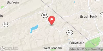
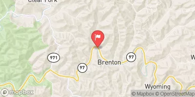
Bluewell Water Supply Dam No.1 is a vital structure located in Brush Fork, Mercer, West Virginia, serving as a significant water supply source for the area.
Summary
The dam, completed in 1966, stands at a height of 36 feet and has a storage capacity of 273 acre-feet, providing essential water resources for the community. Despite its importance, the dam is currently classified as having a high hazard potential and poor condition assessment, highlighting the need for ongoing monitoring and maintenance to ensure its continued safety and functionality.
Managed by the local government, this earth dam on Stone Lick Branch is regulated by the Department of Environmental Protection in West Virginia, with state permit requirements and regular inspections in place to uphold safety standards. The dam's primary purpose is water supply, with a storage capacity of 273 acre-feet and a surface area of 12 acres. However, its condition assessment reports indicate the need for improvements to ensure its long-term stability and effectiveness in providing essential water resources to the surrounding communities.
With a hazard potential rating of high and poor condition assessment, Bluewell Water Supply Dam No.1 stands as a critical infrastructure that requires attention and investment in maintenance and upgrades. The dam plays a crucial role in water supply for the area, emphasizing the importance of ongoing monitoring and management to mitigate risks and ensure the safety and sustainability of this essential water resource in Mercer, West Virginia.
°F
°F
mph
Wind
%
Humidity
15-Day Weather Outlook
Year Completed |
1966 |
Dam Length |
225 |
Dam Height |
36 |
River Or Stream |
STONE LICK BRANCH |
Primary Dam Type |
Earth |
Surface Area |
12 |
Hydraulic Height |
25 |
Drainage Area |
0.8 |
Nid Storage |
273 |
Hazard Potential |
High |
Nid Height |
36 |
Seasonal Comparison
5-Day Hourly Forecast Detail
Nearby Streamflow Levels
 Bluestone River At Falls Mills
|
81cfs |
 Bluestone River Near Pipestem
|
514cfs |
 Tug Fork At Welch
|
340cfs |
 New River At Glen Lyn
|
3570cfs |
 Wolf Creek Near Narrows
|
271cfs |
 Guyandotte River Near Baileysville
|
474cfs |
Dam Data Reference
Condition Assessment
SatisfactoryNo existing or potential dam safety deficiencies are recognized. Acceptable performance is expected under all loading conditions (static, hydrologic, seismic) in accordance with the minimum applicable state or federal regulatory criteria or tolerable risk guidelines.
Fair
No existing dam safety deficiencies are recognized for normal operating conditions. Rare or extreme hydrologic and/or seismic events may result in a dam safety deficiency. Risk may be in the range to take further action. Note: Rare or extreme event is defined by the regulatory agency based on their minimum
Poor A dam safety deficiency is recognized for normal operating conditions which may realistically occur. Remedial action is necessary. POOR may also be used when uncertainties exist as to critical analysis parameters which identify a potential dam safety deficiency. Investigations and studies are necessary.
Unsatisfactory
A dam safety deficiency is recognized that requires immediate or emergency remedial action for problem resolution.
Not Rated
The dam has not been inspected, is not under state or federal jurisdiction, or has been inspected but, for whatever reason, has not been rated.
Not Available
Dams for which the condition assessment is restricted to approved government users.
Hazard Potential Classification
HighDams assigned the high hazard potential classification are those where failure or mis-operation will probably cause loss of human life.
Significant
Dams assigned the significant hazard potential classification are those dams where failure or mis-operation results in no probable loss of human life but can cause economic loss, environment damage, disruption of lifeline facilities, or impact other concerns. Significant hazard potential classification dams are often located in predominantly rural or agricultural areas but could be in areas with population and significant infrastructure.
Low
Dams assigned the low hazard potential classification are those where failure or mis-operation results in no probable loss of human life and low economic and/or environmental losses. Losses are principally limited to the owner's property.
Undetermined
Dams for which a downstream hazard potential has not been designated or is not provided.
Not Available
Dams for which the downstream hazard potential is restricted to approved government users.
 Bluewell Water Supply Dam No.1
 Middle Fork Brush Creek At Edison