Six Mile Landing Boat Launch
Community Reviews
Been here? Share the conditions.
Reviews, ratings & photos are added in the free Snoflo iOS app — rate a spot, tag the conditions, and your visit is verified by location. Add or manage your reviews from the app.
Six Mile Landing
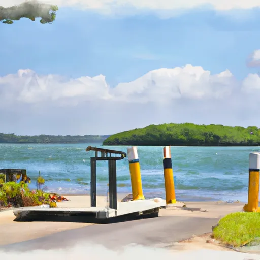
The boat ramp at Six Mile Landing is a concrete ramp that is sturdy enough to handle even large boats. It is 14 feet wide, which makes it easy for boaters to launch and retrieve their craft. The ramp is also equipped with a concrete dock that provides additional space for loading and unloading passengers and gear.
Six Mile Landing is located on the St. Johns River, which is a large and heavily used waterway in Florida. The river is navigable for over 300 miles, from its headwaters in Indian River County to its mouth at the Atlantic Ocean. Boaters on the river can enjoy a variety of activities, including fishing, water skiing, and sightseeing.
A variety of craft are permitted on the water at Six Mile Landing, including motorboats, sailboats, kayaks, and canoes. However, boaters should be aware that the St. Johns River is a busy waterway, and they should take appropriate safety precautions when navigating the river. They should also be aware of any restrictions or regulations that apply to their particular craft or activity.
The information provided is based on the latest available data and may be subject to change. Boaters should check with local authorities or the facility operator for the most up-to-date information on Six Mile Landing and the St. Johns River.
Plan your launch down to the hour
Same weather feed Snoflo's iOS app uses -- updated continuously from NOAA / yr.no.
Next 5 days, hour by hour
Temperature line with weather symbols on top, snow + rain accumulation as columns, humidity as a dotted line.
5-day forecast table
Every 3 hours, broken out across temperature, snow, rain, humidity, and wind.
| Time | Condition | Temp (°F) | Snow (in) | Rain (in) | Humidity (%) | Wind (mps) | Wind dir |
|---|---|---|---|---|---|---|---|
| Loading detailed forecast… | |||||||
15-day temperature & precipitation
Daily temperatures, snow, and rain projected over the next two weeks.
Area streamflow levels
USGS streamgauges around Six Mile Landing -- the same readings that determine whether your launch is safe and your boat is the right craft.
| Streamgauge | Discharge | View |
|---|---|---|
| Julington Crk At Old St August Rd Nr Bayard | 36 cfs | → |
| Pottsburg Creek Nr South Jacksonville | 15 cfs | → |
| St. Johns River At Jacksonville | 169,000 cfs | → |
| Ortega River At Kirwin Rd Nr Jacksonville | 6 cfs | → |
| Cedar River At San Juan Ave At Jacksonville | 30 cfs | → |
| Deep Creek At Spuds | 69 cfs | → |
Plan a longer trip
The closest paddle runs, fishing spots, and other boat launches so you can extend a day on the water.
Nearby fishing
Boating safety & etiquette
- Check the conditions before you launch
- Use the streamflow numbers, weather, and wind forecast on this page. High-cfs whitewater requires whitewater-specific craft and skill.
- Wear your life jacket
- Statistically the single biggest survival factor in a boating incident. State law often requires one per passenger.
- File a float plan
- Tell someone on shore your put-in, take-out, and expected return time. Especially for multi-day or remote trips.
- Yield at the ramp
- Prep gear in the parking lot, not on the ramp. Launch and clear quickly so others can use the lane.
- Clean, drain, dry
- Inspect, clean, drain and dry your boat between waters to prevent the spread of aquatic invasive species.
Set push alerts in the Snoflo app
Save Six Mile Landing as a favorite, set a discharge threshold or a wind/precipitation alert, and the iOS app will push the moment conditions cross.
About Six Mile Landing
Can I launch a motorboat here?
Most Snoflo-tracked launches support motorboats; check the operator for any horsepower restrictions, paddle-only zones, or seasonal closures.
How fresh is the streamflow data?
USGS streamgauges report continuously (every 15 minutes); the table on this page pulls the latest reading at page load.
Is there a fee?
Many federal and state boat launches charge a day-use fee. Check the operator's site before driving out.
What boat is right for these conditions?
Use the nearby streamflow numbers and river-run panel on this page to gauge current conditions. Wider, slower water is friendly for casual paddling and powerboats; high-cfs whitewater requires whitewater-specific craft and skill.
Can I get alerts when conditions change?
Yes -- alerts are managed in the Snoflo iOS app. Favorite this launch, set a threshold (discharge, wind), and you'll get a push the moment it crosses.
Other launches near here
Snoflo-tracked boat launches within driving distance of Six Mile Landing.