Crowder Landing Boat Launch
Community Reviews
Been here? Share the conditions.
Reviews, ratings & photos are added in the free Snoflo iOS app — rate a spot, tag the conditions, and your visit is verified by location. Add or manage your reviews from the app.
Crowder Landing
Crowder Landing is a public boat ramp located in Wakulla County, Florida. It is situated on the eastern shore of the Wakulla River, a significant tributary of the Apalachee Bay. The ramp is accessible from State Route 267, approximately 17 miles south of Tallahassee.
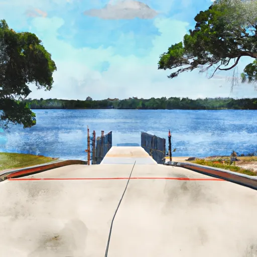
The boat ramp at Crowder Landing is a concrete structure with two launching lanes and a floating dock. It has a width of approximately 16 feet and a length of 40 feet, which is sufficient for most small to medium-sized boats. The ramp has a gradual slope, making it suitable for both powerboats and non-motorized watercraft.
The Wakulla River, which is serviced by Crowder Landing, is a popular destination for recreational boaters, anglers, and paddlers. The river is known for its clear waters, abundant wildlife, and scenic beauty. It is also designated as a Florida Outstanding Waterway, meaning that it is recognized for its exceptional recreational and ecological value.
Boats of various types are permitted on the Wakulla River, including canoes, kayaks, paddleboards, jon boats, and motorized vessels. However, there are some restrictions on the use of motorized boats in certain areas, such as the upper reaches of the river and the Wakulla Springs State Park. Boaters are advised to check the latest regulations and safety guidelines before launching their vessel at Crowder Landing.
Plan your launch down to the hour
Same weather feed Snoflo's iOS app uses -- updated continuously from NOAA / yr.no.
Next 5 days, hour by hour
Temperature line with weather symbols on top, snow + rain accumulation as columns, humidity as a dotted line.
5-day forecast table
Every 3 hours, broken out across temperature, snow, rain, humidity, and wind.
| Time | Condition | Temp (°F) | Snow (in) | Rain (in) | Humidity (%) | Wind (mps) | Wind dir |
|---|---|---|---|---|---|---|---|
| Loading detailed forecast… | |||||||
15-day temperature & precipitation
Daily temperatures, snow, and rain projected over the next two weeks.
Area streamflow levels
USGS streamgauges around Crowder Landing -- the same readings that determine whether your launch is safe and your boat is the right craft.
| Streamgauge | Discharge | View |
|---|---|---|
| Ochlockonee River Nr Havana | 229 cfs | → |
| Ochlockonee River Nr Concord | 221 cfs | → |
| Little River Nr Quincy | 113 cfs | → |
| Little River Nr Midway | 46 cfs | → |
| Little Attapulgus Creek At Attapulgus | 7 cfs | → |
| St. Marks River Near Newport | 476 cfs | → |
Plan a longer trip
The closest paddle runs, fishing spots, and other boat launches so you can extend a day on the water.
River runs
- 2 Miles Below Dam On Lake Talquin To Ochlockonee Bay
- Headwaters To Concrete Bridge (Burnt Bridge) On Fh 13 (Where River Enters Bradwell Ray Wilderness)
- Bradwell Bay Wilderness (Northern Boundary) To Bradwell Bay Wilderness Boundary At Trice Bridge On Fr 329
- Tirce Creek Bridge (Monkey Creek) To Forest Service Property Boundary In Sec 13
- Forest Service Property Bounday To St. Marks Wildlife Refuge Boundary
Nearby fishing
Boating safety & etiquette
- Check the conditions before you launch
- Use the streamflow numbers, weather, and wind forecast on this page. High-cfs whitewater requires whitewater-specific craft and skill.
- Wear your life jacket
- Statistically the single biggest survival factor in a boating incident. State law often requires one per passenger.
- File a float plan
- Tell someone on shore your put-in, take-out, and expected return time. Especially for multi-day or remote trips.
- Yield at the ramp
- Prep gear in the parking lot, not on the ramp. Launch and clear quickly so others can use the lane.
- Clean, drain, dry
- Inspect, clean, drain and dry your boat between waters to prevent the spread of aquatic invasive species.
Set push alerts in the Snoflo app
Save Crowder Landing as a favorite, set a discharge threshold or a wind/precipitation alert, and the iOS app will push the moment conditions cross.
About Crowder Landing
Can I launch a motorboat here?
Most Snoflo-tracked launches support motorboats; check the operator for any horsepower restrictions, paddle-only zones, or seasonal closures.
How fresh is the streamflow data?
USGS streamgauges report continuously (every 15 minutes); the table on this page pulls the latest reading at page load.
Is there a fee?
Many federal and state boat launches charge a day-use fee. Check the operator's site before driving out.
What boat is right for these conditions?
Use the nearby streamflow numbers and river-run panel on this page to gauge current conditions. Wider, slower water is friendly for casual paddling and powerboats; high-cfs whitewater requires whitewater-specific craft and skill.
Can I get alerts when conditions change?
Yes -- alerts are managed in the Snoflo iOS app. Favorite this launch, set a threshold (discharge, wind), and you'll get a push the moment it crosses.
Other launches near here
Snoflo-tracked boat launches within driving distance of Crowder Landing.