Oak Harbor boat launch
Community Reviews
Been here? Share the conditions.
Reviews, ratings & photos are added in the free Snoflo iOS app — rate a spot, tag the conditions, and your visit is verified by location. Add or manage your reviews from the app.
Oak Harbor
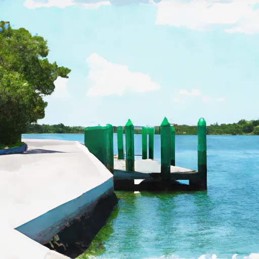
Based on the latest information available, the Oak Harbor boat ramp is located in Jacksonville, Florida, with a latitude of 30.35618591 and a longitude of -81.42825317. It is a public boat ramp that provides access to the Intracoastal Waterway.
The Oak Harbor boat ramp has a concrete launch ramp and a courtesy dock, and it is approximately 20 feet wide. It can accommodate small to medium-sized boats and has parking spaces for vehicles and boat trailers.
The Intracoastal Waterway that the Oak Harbor boat ramp services is a network of bays, rivers, and canals that extends along the East Coast of the United States, from Florida to New Jersey. It is a popular destination for boaters, fishermen, and other water enthusiasts.
As for the type of craft permitted on the water, it depends on the regulations of the local authorities and the size of the boats that the ramp can accommodate. However, in general, common watercraft allowed on the Intracoastal Waterway include powerboats, sailboats, kayaks, canoes, and paddleboards.
In summary, the Oak Harbor boat ramp is a public launch ramp located in Jacksonville, Florida, that provides access to the Intracoastal Waterway. It is approximately 20 feet wide and can accommodate small to medium-sized boats. The Intracoastal Waterway is a popular destination for various types of watercraft, including powerboats, sailboats, kayaks, canoes, and paddleboards.
Plan your launch down to the hour
Same weather feed Snoflo's iOS app uses -- updated continuously from NOAA / yr.no.
Next 5 days, hour by hour
Temperature line with weather symbols on top, snow + rain accumulation as columns, humidity as a dotted line.
5-day forecast table
Every 3 hours, broken out across temperature, snow, rain, humidity, and wind.
| Time | Condition | Temp (°F) | Snow (in) | Rain (in) | Humidity (%) | Wind (mps) | Wind dir |
|---|---|---|---|---|---|---|---|
| Loading detailed forecast… | |||||||
15-day temperature & precipitation
Daily temperatures, snow, and rain projected over the next two weeks.
Area streamflow levels
USGS streamgauges around Oak Harbor -- the same readings that determine whether your launch is safe and your boat is the right craft.
| Streamgauge | Discharge | View |
|---|---|---|
| Pottsburg Creek Nr South Jacksonville | 72 cfs | → |
| St. Johns River At Jacksonville | 191,000 cfs | → |
| Julington Crk At Old St August Rd Nr Bayard | 39 cfs | → |
| Cedar River At San Juan Ave At Jacksonville | 341 cfs | → |
| Ortega River At Kirwin Rd Nr Jacksonville | 7 cfs | → |
Plan a longer trip
The closest paddle runs, fishing spots, and other boat launches so you can extend a day on the water.
Nearby fishing
Boating safety & etiquette
- Check the conditions before you launch
- Use the streamflow numbers, weather, and wind forecast on this page. High-cfs whitewater requires whitewater-specific craft and skill.
- Wear your life jacket
- Statistically the single biggest survival factor in a boating incident. State law often requires one per passenger.
- File a float plan
- Tell someone on shore your put-in, take-out, and expected return time. Especially for multi-day or remote trips.
- Yield at the ramp
- Prep gear in the parking lot, not on the ramp. Launch and clear quickly so others can use the lane.
- Clean, drain, dry
- Inspect, clean, drain and dry your boat between waters to prevent the spread of aquatic invasive species.
Set push alerts in the Snoflo app
Save Oak Harbor as a favorite, set a discharge threshold or a wind/precipitation alert, and the iOS app will push the moment conditions cross.
About Oak Harbor
Can I launch a motorboat here?
Most Snoflo-tracked launches support motorboats; check the operator for any horsepower restrictions, paddle-only zones, or seasonal closures.
How fresh is the streamflow data?
USGS streamgauges report continuously (every 15 minutes); the table on this page pulls the latest reading at page load.
Is there a fee?
Many federal and state boat launches charge a day-use fee. Check the operator's site before driving out.
What boat is right for these conditions?
Use the nearby streamflow numbers and river-run panel on this page to gauge current conditions. Wider, slower water is friendly for casual paddling and powerboats; high-cfs whitewater requires whitewater-specific craft and skill.
Can I get alerts when conditions change?
Yes -- alerts are managed in the Snoflo iOS app. Favorite this launch, set a threshold (discharge, wind), and you'll get a push the moment it crosses.
Other launches near here
Snoflo-tracked boat launches within driving distance of Oak Harbor.