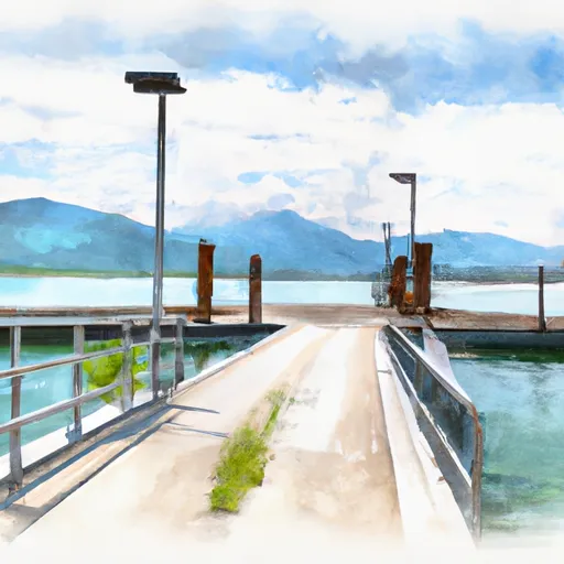
Lavinia Avenue Sandpoint Boat Launch
Community Reviews
Been here? Share the conditions.
Reviews, ratings & photos are added in the free Snoflo iOS app — rate a spot, tag the conditions, and your visit is verified by location. Add or manage your reviews from the app.
Lavinia Avenue Sandpoint
This boat ramp is designed for small to medium-sized watercraft, such as fishing boats, ski boats, and pontoon boats. There are no restrictions on the type of boat that can be launched from this ramp, as long as it is legally registered and compliant with local boating regulations.
It's important to note that local boating regulations can change frequently, so it is always a good idea to check with the appropriate authorities before launching a boat at any location. Additionally, weather and water conditions can also impact the safety of boating activities, so it's essential to exercise caution and follow best practices for safe boating.
Plan your launch down to the hour
Same weather feed Snoflo's iOS app uses -- updated continuously from NOAA / yr.no.
Next 5 days, hour by hour
Temperature line with weather symbols on top, snow + rain accumulation as columns, humidity as a dotted line.
5-day forecast table
Every 3 hours, broken out across temperature, snow, rain, humidity, and wind.
| Time | Condition | Temp (°F) | Snow (in) | Rain (in) | Humidity (%) | Wind (mps) | Wind dir |
|---|---|---|---|---|---|---|---|
| Loading detailed forecast… | |||||||
15-day temperature & precipitation
Daily temperatures, snow, and rain projected over the next two weeks.
Area streamflow levels
USGS streamgauges around Lavinia Avenue Sandpoint -- the same readings that determine whether your launch is safe and your boat is the right craft.
| Streamgauge | Discharge | View |
|---|---|---|
| Pack River Nr Colburn Id | 610 cfs | → |
| Priest River Nr Priest River Id | 262 cfs | → |
| Lightning Creek At Clark Fork Id | 12 cfs | → |
| Priest R Outflow Nr Coolin | 162 cfs | → |
| Pend Oreille River At Newport Wa | 12,900 cfs | → |
| Clark Fork River Below Cabinet Gorge Dam Id | 6,210 cfs | → |
Plan a longer trip
The closest paddle runs, fishing spots, and other boat launches so you can extend a day on the water.
River runs
- Forest Boundary, Sec. 34, T59n, R2w To Harrison Lake, Sec. 31, T62n, R2w
- 10 Miles From Surprise Gulch To A Mile Below Kootenai Vista Estates To 10 Miles From Surprise Gulch To A Mile Below Kootenai Vista Estates
- Kootenai River
- Yaak Falls, Sec. 4, T33n, R33w To Downstream To Bpa Powerline, 6 Miles West Of Troy
- 9 Miles From Quartz Creek To Surprise Gulch,Two Miles Below Kootenai Falls To 9 Miles From Quartz Creek To Surprise Gulch,Two Miles Below Kootenai Falls
Boating safety & etiquette
- Check the conditions before you launch
- Use the streamflow numbers, weather, and wind forecast on this page. High-cfs whitewater requires whitewater-specific craft and skill.
- Wear your life jacket
- Statistically the single biggest survival factor in a boating incident. State law often requires one per passenger.
- File a float plan
- Tell someone on shore your put-in, take-out, and expected return time. Especially for multi-day or remote trips.
- Yield at the ramp
- Prep gear in the parking lot, not on the ramp. Launch and clear quickly so others can use the lane.
- Clean, drain, dry
- Inspect, clean, drain and dry your boat between waters to prevent the spread of aquatic invasive species.
Set push alerts in the Snoflo app
Save Lavinia Avenue Sandpoint as a favorite, set a discharge threshold or a wind/precipitation alert, and the iOS app will push the moment conditions cross.
About Lavinia Avenue Sandpoint
Can I launch a motorboat here?
Most Snoflo-tracked launches support motorboats; check the operator for any horsepower restrictions, paddle-only zones, or seasonal closures.
How fresh is the streamflow data?
USGS streamgauges report continuously (every 15 minutes); the table on this page pulls the latest reading at page load.
Is there a fee?
Many federal and state boat launches charge a day-use fee. Check the operator's site before driving out.
What boat is right for these conditions?
Use the nearby streamflow numbers and river-run panel on this page to gauge current conditions. Wider, slower water is friendly for casual paddling and powerboats; high-cfs whitewater requires whitewater-specific craft and skill.
Can I get alerts when conditions change?
Yes -- alerts are managed in the Snoflo iOS app. Favorite this launch, set a threshold (discharge, wind), and you'll get a push the moment it crosses.
Other launches near here
Snoflo-tracked boat launches within driving distance of Lavinia Avenue Sandpoint.