Hart-Tish Boat Ramp Boat Launch
Community Reviews
Been here? Share the conditions.
Reviews, ratings & photos are added in the free Snoflo iOS app — rate a spot, tag the conditions, and your visit is verified by location. Add or manage your reviews from the app.
Hart-Tish Boat Ramp
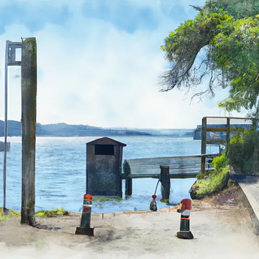
This boat ramp provides access to the Applegate Reservoir, a popular destination for boating and fishing enthusiasts. The reservoir is situated in Jackson County, Oregon, and covers an area of approximately 988 acres.
Based on the latest information available, the Applegate Reservoir permits different types of watercraft, including motorized boats, jet skis, canoes, kayaks, and paddleboards. However, it is important to note that certain regulations and restrictions may apply, such as speed limits and no-wake zones, to ensure the safety of all users.
In conclusion, the Hart-Tish boat ramp in Oregon is a concrete boat ramp that provides access to the Applegate Reservoir. It is wide enough to handle different types of boats and watercraft, and the reservoir permits various watercraft types.
Plan your launch down to the hour
Same weather feed Snoflo's iOS app uses -- updated continuously from NOAA / yr.no.
Next 5 days, hour by hour
Temperature line with weather symbols on top, snow + rain accumulation as columns, humidity as a dotted line.
5-day forecast table
Every 3 hours, broken out across temperature, snow, rain, humidity, and wind.
| Time | Condition | Temp (°F) | Snow (in) | Rain (in) | Humidity (%) | Wind (mps) | Wind dir |
|---|---|---|---|---|---|---|---|
| Loading detailed forecast… | |||||||
15-day temperature & precipitation
Daily temperatures, snow, and rain projected over the next two weeks.
Area streamflow levels
USGS streamgauges around Hart-Tish Boat Ramp -- the same readings that determine whether your launch is safe and your boat is the right craft.
| Streamgauge | Discharge | View |
|---|---|---|
| Applegate River Near Copper | 124 cfs | → |
| Star Gulch Near Ruch | 0 cfs | → |
| Applegate River Near Applegate | 89 cfs | → |
| Klamath R Nr Seiad Valley Ca | 1,100 cfs | → |
| Sucker Cr Bl Lt Grayback Cr Nr Holland | 21 cfs | → |
| Indian C Nr Happy Camp Ca | 43 cfs | → |
Plan a longer trip
The closest paddle runs, fishing spots, and other boat launches so you can extend a day on the water.
River runs
- Applegate River
- Headwaters To Forest Road 960
- Headwaters At 4800 Ft Contour Line To Boundary Of The Cave/Underground River Styx.
- Sluice Box To Green Riffle
- Little Applegate River
- Confluence With Rancheria Creek To Forest Road 46n24x
Nearby fishing
Boating safety & etiquette
- Check the conditions before you launch
- Use the streamflow numbers, weather, and wind forecast on this page. High-cfs whitewater requires whitewater-specific craft and skill.
- Wear your life jacket
- Statistically the single biggest survival factor in a boating incident. State law often requires one per passenger.
- File a float plan
- Tell someone on shore your put-in, take-out, and expected return time. Especially for multi-day or remote trips.
- Yield at the ramp
- Prep gear in the parking lot, not on the ramp. Launch and clear quickly so others can use the lane.
- Clean, drain, dry
- Inspect, clean, drain and dry your boat between waters to prevent the spread of aquatic invasive species.
Set push alerts in the Snoflo app
Save Hart-Tish Boat Ramp as a favorite, set a discharge threshold or a wind/precipitation alert, and the iOS app will push the moment conditions cross.
About Hart-Tish Boat Ramp
Can I launch a motorboat here?
Most Snoflo-tracked launches support motorboats; check the operator for any horsepower restrictions, paddle-only zones, or seasonal closures.
How fresh is the streamflow data?
USGS streamgauges report continuously (every 15 minutes); the table on this page pulls the latest reading at page load.
Is there a fee?
Many federal and state boat launches charge a day-use fee. Check the operator's site before driving out.
What boat is right for these conditions?
Use the nearby streamflow numbers and river-run panel on this page to gauge current conditions. Wider, slower water is friendly for casual paddling and powerboats; high-cfs whitewater requires whitewater-specific craft and skill.
Can I get alerts when conditions change?
Yes -- alerts are managed in the Snoflo iOS app. Favorite this launch, set a threshold (discharge, wind), and you'll get a push the moment it crosses.
Other launches near here
Snoflo-tracked boat launches within driving distance of Hart-Tish Boat Ramp.