Utah County Boat Launch
Community Reviews
Been here? Share the conditions.
Reviews, ratings & photos are added in the free Snoflo iOS app — rate a spot, tag the conditions, and your visit is verified by location. Add or manage your reviews from the app.
Utah County
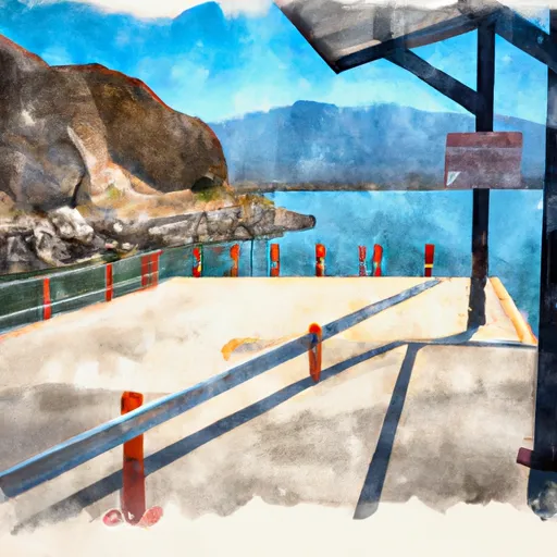
Utah Lake is a large freshwater lake in Utah County, Utah, and the Utah County boat ramp is one of the primary access points for recreational boaters. The lake is known for its excellent fishery, with both warmwater and coldwater species available for anglers to catch. It is also a popular spot for boating, water skiing, and other water sports.
The Utah County boat ramp allows a wide variety of watercraft to be launched, including motorized boats, sailboats, and paddlecraft. However, it is important to note that there are restrictions on the types of boats allowed on Utah Lake. For example, personal watercraft (jet skis) are only allowed on the lake during certain hours of the day, and wakeboarding is prohibited in certain areas.
In summary, the Utah County boat ramp is a concrete boat ramp that provides access to Utah Lake in Utah County, Utah. It is 60 feet wide and can accommodate a variety of watercraft. The lake is known for its excellent fishing and is a popular spot for boating and water sports. However, there are restrictions on the types of boats allowed on the lake, so it is important for boaters to check the latest regulations before launching.
Plan your launch down to the hour
Same weather feed Snoflo's iOS app uses -- updated continuously from NOAA / yr.no.
Next 5 days, hour by hour
Temperature line with weather symbols on top, snow + rain accumulation as columns, humidity as a dotted line.
5-day forecast table
Every 3 hours, broken out across temperature, snow, rain, humidity, and wind.
| Time | Condition | Temp (°F) | Snow (in) | Rain (in) | Humidity (%) | Wind (mps) | Wind dir |
|---|---|---|---|---|---|---|---|
| Loading detailed forecast… | |||||||
15-day temperature & precipitation
Daily temperatures, snow, and rain projected over the next two weeks.
Area streamflow levels
USGS streamgauges around Utah County -- the same readings that determine whether your launch is safe and your boat is the right craft.
| Streamgauge | Discharge | View |
|---|---|---|
| Provo River At Provo | 48 cfs | → |
| Summit Creek Abv Summit Cr Canal Nr Santaquin Ut | 4 cfs | → |
| Hobble Creek At 1650 West At Springville | 16 cfs | → |
| West Canyon Creek Near Cedar Fort | 1 cfs | → |
| Spanish Fork At Castilla | 364 cfs | → |
| Currant Creek Near Mona | 1 cfs | → |
Plan a longer trip
The closest paddle runs, fishing spots, and other boat launches so you can extend a day on the water.
River runs
- Bridal Veil (Bv)
- Spanish Fork
- Eastern Boundary Of National Monument To Western Boundary Of National Monument
- Headwater Spring In Sec 8 To Mt Timpanogos Wilderness Boundary
- Mt Timpanogos Wilderness Boundary To Theater-In-The-Pines
- Confluence Below Timpooneke To Mt Timpanogos Wilderness Boundary
Nearby fishing
Boating safety & etiquette
- Check the conditions before you launch
- Use the streamflow numbers, weather, and wind forecast on this page. High-cfs whitewater requires whitewater-specific craft and skill.
- Wear your life jacket
- Statistically the single biggest survival factor in a boating incident. State law often requires one per passenger.
- File a float plan
- Tell someone on shore your put-in, take-out, and expected return time. Especially for multi-day or remote trips.
- Yield at the ramp
- Prep gear in the parking lot, not on the ramp. Launch and clear quickly so others can use the lane.
- Clean, drain, dry
- Inspect, clean, drain and dry your boat between waters to prevent the spread of aquatic invasive species.
Set push alerts in the Snoflo app
Save Utah County as a favorite, set a discharge threshold or a wind/precipitation alert, and the iOS app will push the moment conditions cross.
About Utah County
Can I launch a motorboat here?
Most Snoflo-tracked launches support motorboats; check the operator for any horsepower restrictions, paddle-only zones, or seasonal closures.
How fresh is the streamflow data?
USGS streamgauges report continuously (every 15 minutes); the table on this page pulls the latest reading at page load.
Is there a fee?
Many federal and state boat launches charge a day-use fee. Check the operator's site before driving out.
What boat is right for these conditions?
Use the nearby streamflow numbers and river-run panel on this page to gauge current conditions. Wider, slower water is friendly for casual paddling and powerboats; high-cfs whitewater requires whitewater-specific craft and skill.
Can I get alerts when conditions change?
Yes -- alerts are managed in the Snoflo iOS app. Favorite this launch, set a threshold (discharge, wind), and you'll get a push the moment it crosses.
Other launches near here
Snoflo-tracked boat launches within driving distance of Utah County.