Forest Hill Road Lake Ridge Boat Launch
Community Reviews
Been here? Share the conditions.
Reviews, ratings & photos are added in the free Snoflo iOS app — rate a spot, tag the conditions, and your visit is verified by location. Add or manage your reviews from the app.
Forest Hill Road Lake Ridge
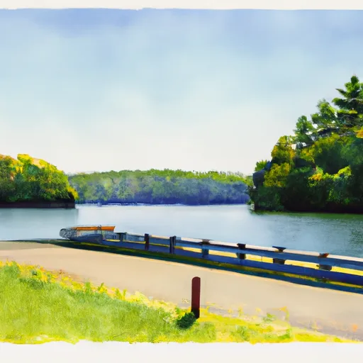
The boat ramp is considered to be a standard concrete ramp with a width of approximately 20 feet, providing ample space for boats to be launched and retrieved. The ramp has a moderate slope suitable for different types of boats. The area around the ramp is well-maintained and provides ample parking spaces for boat trailers.
Forest Hill Road Lake Ridge boat ramp services the Occoquan Reservoir, which is a 2,100-acre lake created by the Occoquan Dam. The lake is popular for recreational activities such as fishing, boating, and jet skiing. The Occoquan Reservoir is a source of drinking water for the Northern Virginia region, and as such, the area around the ramp and on the lake is patrolled by authorities.
A variety of watercraft are permitted on the Occoquan Reservoir, including motorized boats, canoes, kayaks, sailboats, and paddleboards. Boaters are required to have a valid Virginia Department of Wildlife Resources boating license and follow all state regulations. Also, the use of personal watercraft is prohibited on the reservoir.
In conclusion, the Forest Hill Road Lake Ridge boat ramp is a well-maintained public ramp located in Prince William County, Virginia. It services the popular Occoquan Reservoir and offers ample parking and a standard concrete ramp suitable for different types of boats. A variety of watercraft are permitted on the reservoir, and boaters are required to follow all Virginia state regulations.
Plan your launch down to the hour
Same weather feed Snoflo's iOS app uses -- updated continuously from NOAA / yr.no.
Next 5 days, hour by hour
Temperature line with weather symbols on top, snow + rain accumulation as columns, humidity as a dotted line.
5-day forecast table
Every 3 hours, broken out across temperature, snow, rain, humidity, and wind.
| Time | Condition | Temp (°F) | Snow (in) | Rain (in) | Humidity (%) | Wind (mps) | Wind dir |
|---|---|---|---|---|---|---|---|
| Loading detailed forecast… | |||||||
15-day temperature & precipitation
Daily temperatures, snow, and rain projected over the next two weeks.
Area streamflow levels
USGS streamgauges around Forest Hill Road Lake Ridge -- the same readings that determine whether your launch is safe and your boat is the right craft.
| Streamgauge | Discharge | View |
|---|---|---|
| Long Branch Near Annandale | 1 cfs | → |
| Accotink Creek Near Annandale | 3 cfs | → |
| S F Quantico Creek Near Independent Hill | 0 cfs | → |
| Cameron Run At Alexandria | 4 cfs | → |
| Mattawoman Creek Near Pomonkey | 1 cfs | → |
| Fourmile Run At Alexandria | 2 cfs | → |
Plan a longer trip
The closest paddle runs, fishing spots, and other boat launches so you can extend a day on the water.
Boating safety & etiquette
- Check the conditions before you launch
- Use the streamflow numbers, weather, and wind forecast on this page. High-cfs whitewater requires whitewater-specific craft and skill.
- Wear your life jacket
- Statistically the single biggest survival factor in a boating incident. State law often requires one per passenger.
- File a float plan
- Tell someone on shore your put-in, take-out, and expected return time. Especially for multi-day or remote trips.
- Yield at the ramp
- Prep gear in the parking lot, not on the ramp. Launch and clear quickly so others can use the lane.
- Clean, drain, dry
- Inspect, clean, drain and dry your boat between waters to prevent the spread of aquatic invasive species.
Set push alerts in the Snoflo app
Save Forest Hill Road Lake Ridge as a favorite, set a discharge threshold or a wind/precipitation alert, and the iOS app will push the moment conditions cross.
About Forest Hill Road Lake Ridge
Can I launch a motorboat here?
Most Snoflo-tracked launches support motorboats; check the operator for any horsepower restrictions, paddle-only zones, or seasonal closures.
How fresh is the streamflow data?
USGS streamgauges report continuously (every 15 minutes); the table on this page pulls the latest reading at page load.
Is there a fee?
Many federal and state boat launches charge a day-use fee. Check the operator's site before driving out.
What boat is right for these conditions?
Use the nearby streamflow numbers and river-run panel on this page to gauge current conditions. Wider, slower water is friendly for casual paddling and powerboats; high-cfs whitewater requires whitewater-specific craft and skill.
Can I get alerts when conditions change?
Yes -- alerts are managed in the Snoflo iOS app. Favorite this launch, set a threshold (discharge, wind), and you'll get a push the moment it crosses.
Other launches near here
Snoflo-tracked boat launches within driving distance of Forest Hill Road Lake Ridge.