Ferry Dock King County Boat Launch
Community Reviews
Been here? Share the conditions.
Reviews, ratings & photos are added in the free Snoflo iOS app — rate a spot, tag the conditions, and your visit is verified by location. Add or manage your reviews from the app.
Ferry Dock King County
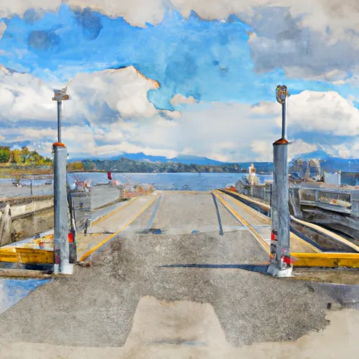
The Ferry Dock King County boat ramp is managed by King County Parks and is open year-round. The ramp is designed to provide easy access to the water for boaters of all skill levels, with a gradual slope and plenty of space for launching and retrieving boats. The ramp also features a dock for loading and unloading passengers and gear.
In terms of permitted watercraft, the Ferry Dock King County boat ramp allows for a variety of vessels, including motorized and non-motorized boats, sailboats, and personal watercraft. However, it is important to note that certain safety regulations and requirements may apply based on the size, type, and horsepower of the vessel being launched.
Overall, the Ferry Dock King County boat ramp is a convenient and accessible option for boaters in the greater Seattle area, offering easy access to Elliot Bay and the surrounding waters of Puget Sound.
Plan your launch down to the hour
Same weather feed Snoflo's iOS app uses -- updated continuously from NOAA / yr.no.
Next 5 days, hour by hour
Temperature line with weather symbols on top, snow + rain accumulation as columns, humidity as a dotted line.
5-day forecast table
Every 3 hours, broken out across temperature, snow, rain, humidity, and wind.
| Time | Condition | Temp (°F) | Snow (in) | Rain (in) | Humidity (%) | Wind (mps) | Wind dir |
|---|---|---|---|---|---|---|---|
| Loading detailed forecast… | |||||||
15-day temperature & precipitation
Daily temperatures, snow, and rain projected over the next two weeks.
Area streamflow levels
USGS streamgauges around Ferry Dock King County -- the same readings that determine whether your launch is safe and your boat is the right craft.
| Streamgauge | Discharge | View |
|---|---|---|
| Duwamish River At Golf Course At Tukwila | 640 cfs | → |
| Mill Creek Near Mouth At Orillia | 0 cfs | → |
| Spring Brook Creek At Orillia | 2 cfs | → |
| Cedar River At Renton | 172 cfs | → |
| Huge Creek Near Wauna | 5 cfs | → |
| Mill Creek At Earthworks Park At Kent | 1 cfs | → |
Plan a longer trip
The closest paddle runs, fishing spots, and other boat launches so you can extend a day on the water.
River runs
- Brothers Wilderness Boundary To Olympic Nf Boundary
- Snoqualmie Falls To Plum's Landing
- Olympic Nf/Olympic Np Bounary To Brothers Wilderness Boundary
- Confluence With Taylor River To Confluence With North Fork Snoqualmie River
- Wagner Bridge To Confluence With Middle Fork Snoqualmie River
- Headwaters- Includes All Tributaries (Upstream From Station Creek) To Confluence With Dosewallips River
Boating safety & etiquette
- Check the conditions before you launch
- Use the streamflow numbers, weather, and wind forecast on this page. High-cfs whitewater requires whitewater-specific craft and skill.
- Wear your life jacket
- Statistically the single biggest survival factor in a boating incident. State law often requires one per passenger.
- File a float plan
- Tell someone on shore your put-in, take-out, and expected return time. Especially for multi-day or remote trips.
- Yield at the ramp
- Prep gear in the parking lot, not on the ramp. Launch and clear quickly so others can use the lane.
- Clean, drain, dry
- Inspect, clean, drain and dry your boat between waters to prevent the spread of aquatic invasive species.
Set push alerts in the Snoflo app
Save Ferry Dock King County as a favorite, set a discharge threshold or a wind/precipitation alert, and the iOS app will push the moment conditions cross.
About Ferry Dock King County
Can I launch a motorboat here?
Most Snoflo-tracked launches support motorboats; check the operator for any horsepower restrictions, paddle-only zones, or seasonal closures.
How fresh is the streamflow data?
USGS streamgauges report continuously (every 15 minutes); the table on this page pulls the latest reading at page load.
Is there a fee?
Many federal and state boat launches charge a day-use fee. Check the operator's site before driving out.
What boat is right for these conditions?
Use the nearby streamflow numbers and river-run panel on this page to gauge current conditions. Wider, slower water is friendly for casual paddling and powerboats; high-cfs whitewater requires whitewater-specific craft and skill.
Can I get alerts when conditions change?
Yes -- alerts are managed in the Snoflo iOS app. Favorite this launch, set a threshold (discharge, wind), and you'll get a push the moment it crosses.
Other launches near here
Snoflo-tracked boat launches within driving distance of Ferry Dock King County.