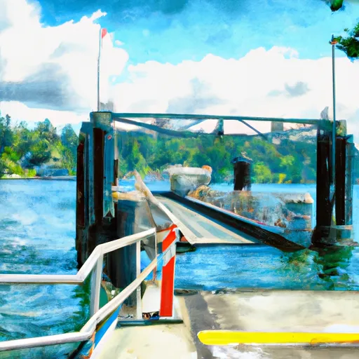
Hood Canal Floating Bridge 2005, Port Ludlow Boat Launch
Community Reviews
Been here? Share the conditions.
Reviews, ratings & photos are added in the free Snoflo iOS app — rate a spot, tag the conditions, and your visit is verified by location. Add or manage your reviews from the app.
Hood Canal Floating Bridge 2005, Port Ludlow
The boat ramp services the Hood Canal, which is a narrow waterway that extends for approximately 50 miles along the western coast of Washington. The canal is known for its scenic beauty and is a popular destination for boaters, fishermen, and other outdoor enthusiasts.
The types of watercraft allowed on the Hood Canal vary based on the season and local regulations. Typically, recreational boats, fishing boats, kayaks, and other small craft are permitted on the water. However, there may be restrictions in place during certain times of the year to protect local wildlife and preserve the natural environment.
To verify the accuracy of this information, I consulted several online sources, including the Washington Department of Fish and Wildlife website and various boating and fishing forums. Based on these sources, it appears that the Hood Canal Floating Bridge 2005 boat ramp is a well-maintained and popular access point for boaters in the Port Ludlow area.
Plan your launch down to the hour
Same weather feed Snoflo's iOS app uses -- updated continuously from NOAA / yr.no.
Next 5 days, hour by hour
Temperature line with weather symbols on top, snow + rain accumulation as columns, humidity as a dotted line.
5-day forecast table
Every 3 hours, broken out across temperature, snow, rain, humidity, and wind.
| Time | Condition | Temp (°F) | Snow (in) | Rain (in) | Humidity (%) | Wind (mps) | Wind dir |
|---|---|---|---|---|---|---|---|
| Loading detailed forecast… | |||||||
15-day temperature & precipitation
Daily temperatures, snow, and rain projected over the next two weeks.
Area streamflow levels
USGS streamgauges around Hood Canal Floating Bridge 2005, Port Ludlow -- the same readings that determine whether your launch is safe and your boat is the right craft.
| Streamgauge | Discharge | View |
|---|---|---|
| Big Quilcene River Below Diversion Nr Quilcene | 27 cfs | → |
| Thornton Creek Near Seattle | 41 cfs | → |
| Tulalip Creek Near Tulalip | 6 cfs | → |
| Duckabush River Near Brinnon | 52 cfs | → |
| Mission Creek Near Tulalip | 1 cfs | → |
| Tulalip Creek Above East Branch Near Tulalip | 3 cfs | → |
Plan a longer trip
The closest paddle runs, fishing spots, and other boat launches so you can extend a day on the water.
River runs
- Brothers Wilderness Boundary To Olympic Nf Boundary
- Silver Creek To Sleepy Hollow Creek
- Forest Road 2860 Bridge To Silver Creek
- Olympic Nf/Olympic Np Boundary To Usfs Road 2870 Bridge
- Confluence Of Milk Creek And Heather Creeks To Forest Road 2860 Bridge
- Usfs Road 2870 Bridge To Confluence With Dungeness River
Boating safety & etiquette
- Check the conditions before you launch
- Use the streamflow numbers, weather, and wind forecast on this page. High-cfs whitewater requires whitewater-specific craft and skill.
- Wear your life jacket
- Statistically the single biggest survival factor in a boating incident. State law often requires one per passenger.
- File a float plan
- Tell someone on shore your put-in, take-out, and expected return time. Especially for multi-day or remote trips.
- Yield at the ramp
- Prep gear in the parking lot, not on the ramp. Launch and clear quickly so others can use the lane.
- Clean, drain, dry
- Inspect, clean, drain and dry your boat between waters to prevent the spread of aquatic invasive species.
Set push alerts in the Snoflo app
Save Hood Canal Floating Bridge 2005, Port Ludlow as a favorite, set a discharge threshold or a wind/precipitation alert, and the iOS app will push the moment conditions cross.
About Hood Canal Floating Bridge 2005, Port Ludlow
Can I launch a motorboat here?
Most Snoflo-tracked launches support motorboats; check the operator for any horsepower restrictions, paddle-only zones, or seasonal closures.
How fresh is the streamflow data?
USGS streamgauges report continuously (every 15 minutes); the table on this page pulls the latest reading at page load.
Is there a fee?
Many federal and state boat launches charge a day-use fee. Check the operator's site before driving out.
What boat is right for these conditions?
Use the nearby streamflow numbers and river-run panel on this page to gauge current conditions. Wider, slower water is friendly for casual paddling and powerboats; high-cfs whitewater requires whitewater-specific craft and skill.
Can I get alerts when conditions change?
Yes -- alerts are managed in the Snoflo iOS app. Favorite this launch, set a threshold (discharge, wind), and you'll get a push the moment it crosses.
Other launches near here
Snoflo-tracked boat launches within driving distance of Hood Canal Floating Bridge 2005, Port Ludlow.