Southwest Harbor Drive 8900, Vashon Boat Launch
Community Reviews
Been here? Share the conditions.
Reviews, ratings & photos are added in the free Snoflo iOS app — rate a spot, tag the conditions, and your visit is verified by location. Add or manage your reviews from the app.
Southwest Harbor Drive 8900, Vashon
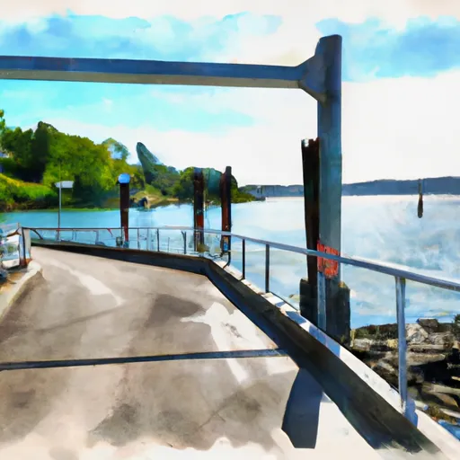
This boat ramp services the water body known as Quartermaster Harbor, which is located on the eastern shore of Vashon Island. It is a popular spot for recreational boating, fishing, and crabbing. The water is relatively calm, making it suitable for small boats, kayaks, and canoes.
The craft permitted on the water include small powerboats, sailboats, paddleboards, kayaks, and canoes. However, there are restrictions on the size and horsepower of the boats allowed on the water, and all vessels must comply with state boating regulations.
Overall, the Southwest Harbor Drive 8900 boat ramp is a convenient and popular spot for boaters and water enthusiasts looking to explore Quartermaster Harbor and the surrounding area.
Plan your launch down to the hour
Same weather feed Snoflo's iOS app uses -- updated continuously from NOAA / yr.no.
Next 5 days, hour by hour
Temperature line with weather symbols on top, snow + rain accumulation as columns, humidity as a dotted line.
5-day forecast table
Every 3 hours, broken out across temperature, snow, rain, humidity, and wind.
| Time | Condition | Temp (°F) | Snow (in) | Rain (in) | Humidity (%) | Wind (mps) | Wind dir |
|---|---|---|---|---|---|---|---|
| Loading detailed forecast… | |||||||
15-day temperature & precipitation
Daily temperatures, snow, and rain projected over the next two weeks.
Area streamflow levels
USGS streamgauges around Southwest Harbor Drive 8900, Vashon -- the same readings that determine whether your launch is safe and your boat is the right craft.
| Streamgauge | Discharge | View |
|---|---|---|
| Mill Creek Near Mouth At Orillia | 0 cfs | → |
| Mill Creek At Earthworks Park At Kent | 1 cfs | → |
| Spring Brook Creek At Orillia | 2 cfs | → |
| Duwamish River At Golf Course At Tukwila | 365 cfs | → |
| Huge Creek Near Wauna | 5 cfs | → |
| Leach Creek Near Fircrest | 2 cfs | → |
Plan a longer trip
The closest paddle runs, fishing spots, and other boat launches so you can extend a day on the water.
River runs
- Snoqualmie Falls To Plum's Landing
- Brothers Wilderness Boundary To Olympic Nf Boundary
- Confluence With Taylor River To Confluence With North Fork Snoqualmie River
- Wagner Bridge To Confluence With Middle Fork Snoqualmie River
- Huckleberry Creek To Confluence With Clearwater River
- Olympic Nf/Olympic Np Bounary To Brothers Wilderness Boundary
Boating safety & etiquette
- Check the conditions before you launch
- Use the streamflow numbers, weather, and wind forecast on this page. High-cfs whitewater requires whitewater-specific craft and skill.
- Wear your life jacket
- Statistically the single biggest survival factor in a boating incident. State law often requires one per passenger.
- File a float plan
- Tell someone on shore your put-in, take-out, and expected return time. Especially for multi-day or remote trips.
- Yield at the ramp
- Prep gear in the parking lot, not on the ramp. Launch and clear quickly so others can use the lane.
- Clean, drain, dry
- Inspect, clean, drain and dry your boat between waters to prevent the spread of aquatic invasive species.
Set push alerts in the Snoflo app
Save Southwest Harbor Drive 8900, Vashon as a favorite, set a discharge threshold or a wind/precipitation alert, and the iOS app will push the moment conditions cross.
About Southwest Harbor Drive 8900, Vashon
Can I launch a motorboat here?
Most Snoflo-tracked launches support motorboats; check the operator for any horsepower restrictions, paddle-only zones, or seasonal closures.
How fresh is the streamflow data?
USGS streamgauges report continuously (every 15 minutes); the table on this page pulls the latest reading at page load.
Is there a fee?
Many federal and state boat launches charge a day-use fee. Check the operator's site before driving out.
What boat is right for these conditions?
Use the nearby streamflow numbers and river-run panel on this page to gauge current conditions. Wider, slower water is friendly for casual paddling and powerboats; high-cfs whitewater requires whitewater-specific craft and skill.
Can I get alerts when conditions change?
Yes -- alerts are managed in the Snoflo iOS app. Favorite this launch, set a threshold (discharge, wind), and you'll get a push the moment it crosses.
Other launches near here
Snoflo-tracked boat launches within driving distance of Southwest Harbor Drive 8900, Vashon.