Bridalveil Creek Campground
Community Reviews
Been here? Share the conditions.
Reviews, ratings & photos are added in the free Snoflo iOS app — rate a spot, tag the conditions, and your visit is verified by location. Add or manage your reviews from the app.
Bridalveil Creek
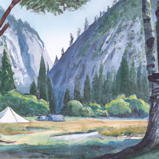
Nearby points of interest include the Merced River, which runs alongside the campground, and the stunning Bridalveil Fall, which is just a short hike away. Visitors can also explore the Yosemite Valley, where they can see the iconic El Capitan and Half Dome rock formations. The area is also home to various hiking and biking trails, giving visitors plenty of opportunities to explore the great outdoors.
Campground amenities include restrooms, picnic tables, fire pits, and food lockers for campers' convenience. The campground also offers access to potable water and a dump station for RVs.
Interesting facts about the area include the Bridalveil Fall, which is named for the mist that resembles a bride's veil, and the Yosemite Valley, which is home to some of the world's largest granite monoliths. Visitors can also spot a range of wildlife in the area, including black bears, coyotes, and deer.
The best time of year to visit Bridalveil Creek camping area is during the summer months, from June to August, when the average temperature is around 80°F during the day and 50°F at night. However, visitors should be aware that the campground can be crowded during peak season, so it's best to reserve a spot in advance.
What's on-site at Bridalveil Creek
Key facilities Snoflo tracks for this campground. Confirm with the operator before booking -- amenities can change seasonally.
Plan your trip down to the hour
Same weather feed Snoflo's iOS app uses -- updated continuously from NOAA / yr.no.
Next 5 days, hour by hour
Temperature line with weather symbols on top, snow + rain accumulation as columns, humidity as a dotted line.
5-day forecast table
Every 3 hours, broken out across temperature, snow, rain, humidity, and wind. Each cell is colour-coded relative to the column min/max so trends jump out at a glance.
| Time | Condition | Temp (°F) | Snow (in) | Rain (in) | Humidity (%) | Wind (mps) | Wind dir |
|---|---|---|---|---|---|---|---|
| Loading detailed forecast… | |||||||
15-day temperature & precipitation
Daily temperatures, snow, and rain projected over the next two weeks. Hover any point for the full breakdown.
Other campgrounds in the area
Snoflo-tracked campsites within driving distance of Bridalveil Creek, with reservations status.
| Campground | Reservations | Toilets | View |
|---|---|---|---|
| Bridalveil Creek - Yosemite National Park | ✗ | ✓ | → |
| Yellow Pines Campground | ✗ | ✗ | → |
| Upper Pines - Yosemite National Park | ✓ | ✓ | → |
| Lower River - Yosemite National Park | ✗ | ✗ | → |
| Upper Pines | ✗ | ✗ | → |
Nearby streamflow
USGS streamgauges within reach of Bridalveil Creek -- pulled live from the National Water Information System.
| Streamgauge | Discharge | View |
|---|---|---|
| Merced R A Pohono Bridge Nr Yosemite Ca | 88 cfs | → |
| Merced R A Happy Isles Bridge Nr Yosemite Ca | 68 cfs | → |
| Big C Div Nr Fish Camp Ca | 0 cfs | → |
| Tuolumne R A Grand Cyn Of Tuolumne Ab Hetch Hetchy | 107 cfs | → |
| Nf Willow C Nr Sugar Pine Ca | 416 cfs | → |
| Tuolumne R Nr Hetch Hetchy Ca | 111 cfs | → |
Nearby snow depths
NRCS SNOTEL stations within reach of Bridalveil Creek -- relevant when planning a shoulder-season or alpine trip.
| SNOTEL station | Snowpack | 24h Snowfall | View |
|---|---|---|---|
| Nohrsc White Wolf Raws | 0.2 in | 0.0 in | → |
| Tenaya Lake | 0.2 in | 0.0 in | → |
| Nohrsc Poison Ridge | 0.0 in | 0.0 in | → |
| Nohrsc Chilkoot Meadow | 0.2 in | 0.0 in | → |
| Ahwahnee 2.5 Nnw | 0.0 in | 0.0 in | → |
| Nohrsc Tuolumne Meadows | 124.2 in | 0.0 in | → |
Plan a longer trip
The closest parks, lakes, boat launches, and paddle runs so a camping night can grow into a full weekend.
Parks
- Yosemite National Park
- Stanislaus National Forest
- Hoover Wilderness
- Wilderness Emigrant
- Devils Postpile National Monument
- Owens River Headwaters Wilderness
Fishing spots
Points of interest
Paddle runs
- Headwaters Near The Tuolumne And Mariposa County Lines To Western Boundary Of Yosemite National Park
- Headwaters In Sec 8, T3s, R25 E To Hemlock Crossing
- Hemlock Crossing To Confluence With Cora Creek
- Cora Creek To Confluence With San Joaquin River
- Rainbow Falls To Confluence With North Fork San Joaquin River
Camping essentials & Leave No Trace
- Pack it in, pack it out
- Take all trash, food scraps, and gear back with you to keep campsites clean and protect wildlife.
- Respect wildlife
- Observe animals from a distance, store food securely, and never feed wildlife to maintain natural behavior and safety.
- Know before you go
- Check weather, fire restrictions, trail conditions, and permit requirements to ensure a safe and well-planned trip.
- Minimize campfire impact
- Use established fire rings, keep fires small, fully extinguish them, or opt for a camp stove when fires are restricted.
- Leave what you find
- Preserve natural and cultural features by avoiding removal of plants, rocks, artifacts, or other elements of the environment.
Set push alerts in the Snoflo app
Save Bridalveil Creek as a favorite, set a custom threshold (precipitation, snowpack, freezing temperatures), and the iOS app will push the moment conditions cross.
About Bridalveil Creek
Can I make reservations at Bridalveil Creek?
This campground does not appear to accept reservations -- it's typically first-come, first-served. Arrive early on summer weekends.
How fresh is the weather data on this page?
The hourly forecast updates throughout the day from the NOAA / yr.no public feeds. Streamflow data is pulled live from USGS streamgauges and snowpack from the NRCS SNOTEL network.
What's the best time of year to visit?
Use the 15-day temperature & precipitation outlook on this page to plan -- pick a window with comfortable temperatures and low precipitation. For longer trips, the 5-day hourly meteogram shows snow + rain accumulation hour-by-hour.
How do I get to Bridalveil Creek?
Tap Directions in the hero above to open driving directions in Google Maps, or Open in map to center the Snoflo interactive map on the campground.
Can I get alerts when conditions change?
Yes -- alerts are managed through the Snoflo iOS app. Favorite this campground, set a threshold (temperature, snowpack, precipitation), and you'll get a push the moment it crosses.
Other campgrounds near here
Snoflo-tracked campgrounds within driving distance of Bridalveil Creek.