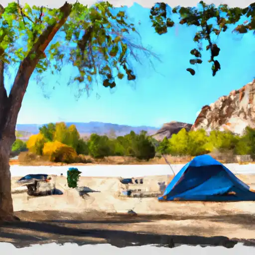
Mojave River Forks Regional Park Campground
Community Reviews
Been here? Share the conditions.
Reviews, ratings & photos are added in the free Snoflo iOS app — rate a spot, tag the conditions, and your visit is verified by location. Add or manage your reviews from the app.
Mojave River Forks Regional Park
Reservations are accepted at Mojave River Forks Regional Park camping area, ensuring campers can secure their spot in advance. This is particularly beneficial during peak seasons when the campground tends to get busy. It is advisable to make reservations to guarantee a spot, especially if planning to visit during weekends or holidays.
The best time to visit Mojave River Forks Regional Park camping area is during the spring and fall seasons when the weather is pleasant and mild. The temperatures during these seasons are ideal for outdoor activities, such as hiking and camping. However, it is essential to note that summers can be extremely hot, so it is recommended to plan accordingly and bring sufficient water and sun protection.
While enjoying the camping area, visitors should be cautious of potential wildlife encounters, as the park is home to various species. It is important to store food securely to prevent attracting animals and to follow proper safety guidelines. Additionally, campers should be mindful of any fire restrictions in place and adhere to them to prevent wildfires and protect the natural surroundings.
Overall, Mojave River Forks Regional Park camping area offers a well-equipped and scenic camping experience, making it a popular choice for outdoor enthusiasts seeking relaxation and adventure in California.
What's on-site at Mojave River Forks Regional Park
Key facilities Snoflo tracks for this campground. Confirm with the operator before booking -- amenities can change seasonally.
Plan your trip down to the hour
Same weather feed Snoflo's iOS app uses -- updated continuously from NOAA / yr.no.
Next 5 days, hour by hour
Temperature line with weather symbols on top, snow + rain accumulation as columns, humidity as a dotted line.
5-day forecast table
Every 3 hours, broken out across temperature, snow, rain, humidity, and wind. Each cell is colour-coded relative to the column min/max so trends jump out at a glance.
| Time | Condition | Temp (°F) | Snow (in) | Rain (in) | Humidity (%) | Wind (mps) | Wind dir |
|---|---|---|---|---|---|---|---|
| Loading detailed forecast… | |||||||
15-day temperature & precipitation
Daily temperatures, snow, and rain projected over the next two weeks. Hover any point for the full breakdown.
Other campgrounds in the area
Snoflo-tracked campsites within driving distance of Mojave River Forks Regional Park, with reservations status.
| Campground | Reservations | Toilets | View |
|---|---|---|---|
| Camping Area | ✗ | ✗ | → |
| Trailer & Rv Area | ✗ | ✗ | → |
| Juniper Flats Group Camping Area | ✗ | ✗ | → |
| Coyote Bluff Group Camping Area | ✗ | ✗ | → |
| Mesa Group Camping Area | ✗ | ✗ | → |
Nearby streamflow
USGS streamgauges within reach of Mojave River Forks Regional Park -- pulled live from the National Water Information System.
| Streamgauge | Discharge | View |
|---|---|---|
| Wf Mojave R Ab Mojave R Forks Res Nr Hesperia Ca | · | → |
| Deep C Nr Hesperia Ca | 1 cfs | → |
| Devil Cyn C Nr San Bernardino Ca | 1 cfs | → |
| Waterman Cyn C Nr Arrowhead Spgs Ca | 0 cfs | → |
| E Twin C Nr Arrowhead Springs Ca | 0 cfs | → |
| Lone Pine C Nr Keenbrook Ca | 1 cfs | → |
Nearby snow depths
NRCS SNOTEL stations within reach of Mojave River Forks Regional Park -- relevant when planning a shoulder-season or alpine trip.
| SNOTEL station | Snowpack | 24h Snowfall | View |
|---|---|---|---|
| Hesperia 1ene | 0.0 in | 0.0 in | → |
| Lake Arrowhead 1.5 Se | 0.0 in | 0.0 in | → |
| Barstow Fire Station | 0.0 in | 0.0 in | → |
| Johnson Valley | 0.0 in | 0.0 in | → |
Plan a longer trip
The closest parks, lakes, boat launches, and paddle runs so a camping night can grow into a full weekend.
Parks
- Mojave River Forks Regional Park
- Hesperia Lake Park
- Silverwood Lake State Recreation Area
- Lime Street Park/Community Center
- Timberlane Park
- Lake Gregory Regional Park
Boat launches
- Silverwood Lake Marina
- Pacific Crest Trail, Hesperia
- Lake Arrowhead Yacht Club
- Duane Boyer (West)
- Pleasure Point Landing
- Holloway's Marina, Inc.
Fishing spots
- Silverwood Lake
- Silverwood Lake State Recreation Area
- Lake Gregory County Regional Park
- Lake Gregory
- Deep Creek
- Glen Helen Lakes
Points of interest
- Lake Silverwood Scenic Overlook
- Mountain History Museum
- Nature Center
- Lake Arrowhead Queen
- Red Rock Scenic Overlook
- Robert Brownlee Observatory
Paddle runs
- Below 2w01 Crossing To Mojave Reservoir
- Below Deep Creek Lake To Below 2w01 Crossing
- Nfsr 3n16 To Confluence With Deep Creek
- Middle Fork - Commanche Campsite To Middle Fork Trailhead
- Big Bear Dam To Private Land In Sec 19, T1n, R1w
- Bluff Lake To Confluence With Bear Creek
Camping essentials & Leave No Trace
- Pack it in, pack it out
- Take all trash, food scraps, and gear back with you to keep campsites clean and protect wildlife.
- Respect wildlife
- Observe animals from a distance, store food securely, and never feed wildlife to maintain natural behavior and safety.
- Know before you go
- Check weather, fire restrictions, trail conditions, and permit requirements to ensure a safe and well-planned trip.
- Minimize campfire impact
- Use established fire rings, keep fires small, fully extinguish them, or opt for a camp stove when fires are restricted.
- Leave what you find
- Preserve natural and cultural features by avoiding removal of plants, rocks, artifacts, or other elements of the environment.
Set push alerts in the Snoflo app
Save Mojave River Forks Regional Park as a favorite, set a custom threshold (precipitation, snowpack, freezing temperatures), and the iOS app will push the moment conditions cross.
About Mojave River Forks Regional Park
Can I make reservations at Mojave River Forks Regional Park?
This campground does not appear to accept reservations -- it's typically first-come, first-served. Arrive early on summer weekends.
How fresh is the weather data on this page?
The hourly forecast updates throughout the day from the NOAA / yr.no public feeds. Streamflow data is pulled live from USGS streamgauges and snowpack from the NRCS SNOTEL network.
What's the best time of year to visit?
Use the 15-day temperature & precipitation outlook on this page to plan -- pick a window with comfortable temperatures and low precipitation. For longer trips, the 5-day hourly meteogram shows snow + rain accumulation hour-by-hour.
How do I get to Mojave River Forks Regional Park?
Tap Directions in the hero above to open driving directions in Google Maps, or Open in map to center the Snoflo interactive map on the campground.
Can I get alerts when conditions change?
Yes -- alerts are managed through the Snoflo iOS app. Favorite this campground, set a threshold (temperature, snowpack, precipitation), and you'll get a push the moment it crosses.
Other campgrounds near here
Snoflo-tracked campgrounds within driving distance of Mojave River Forks Regional Park.