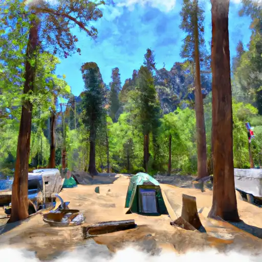
South Fork - Sequoia National Park Campground
Community Reviews
Been here? Share the conditions.
Reviews, ratings & photos are added in the free Snoflo iOS app — rate a spot, tag the conditions, and your visit is verified by location. Add or manage your reviews from the app.
South Fork - Sequoia National Park
Reservations are highly recommended for South Fork campground, as it operates on a first-come, first-served basis. Visitors can secure their spots up to six months in advance, providing an opportunity for a stress-free camping experience. The best time to visit South Fork campground is during the summer months when the weather is mild and perfect for outdoor activities. However, it's important to note that temperatures can drop significantly at night, so campers should come prepared with warm clothing and appropriate gear.
South Fork campground offers access to various hiking trails, including the picturesque South Fork Trail, which leads to magnificent waterfalls and breathtaking vistas. Wildlife enthusiasts will enjoy the opportunity to spot black bears, mule deer, and a variety of bird species in their natural habitat. However, campers should exercise caution and keep a safe distance from wildlife, storing food securely to prevent any unwanted encounters. Overall, South Fork campground provides a fantastic camping experience with its amenities, stunning surroundings, and opportunities for exploration and enjoyment.
What's on-site at South Fork - Sequoia National Park
Key facilities Snoflo tracks for this campground. Confirm with the operator before booking -- amenities can change seasonally.
Plan your trip down to the hour
Same weather feed Snoflo's iOS app uses -- updated continuously from NOAA / yr.no.
Next 5 days, hour by hour
Temperature line with weather symbols on top, snow + rain accumulation as columns, humidity as a dotted line.
5-day forecast table
Every 3 hours, broken out across temperature, snow, rain, humidity, and wind. Each cell is colour-coded relative to the column min/max so trends jump out at a glance.
| Time | Condition | Temp (°F) | Snow (in) | Rain (in) | Humidity (%) | Wind (mps) | Wind dir |
|---|---|---|---|---|---|---|---|
| Loading detailed forecast… | |||||||
15-day temperature & precipitation
Daily temperatures, snow, and rain projected over the next two weeks. Hover any point for the full breakdown.
Other campgrounds in the area
Snoflo-tracked campsites within driving distance of South Fork - Sequoia National Park, with reservations status.
| Campground | Reservations | Toilets | View |
|---|---|---|---|
| Grouse Valley Cabin Complex | ✓ | ✗ | → |
| Hidden Falls - State Forest | ✗ | ✓ | → |
| Shake Camp Campground | ✗ | ✗ | → |
| Shake Camp - State Forest | ✗ | ✓ | → |
| Frazier Mill - State Forest | ✗ | ✓ | → |
Nearby streamflow
USGS streamgauges within reach of South Fork - Sequoia National Park -- pulled live from the National Water Information System.
| Streamgauge | Discharge | View |
|---|---|---|
| Marble Fork Kaweah R Ab Horse C Nr Lodgepole Ca | 1 cfs | → |
| Sf Tule R Nr Cholollo Campground Nr Porterville Ca | 8 cfs | → |
| Sf Tule R Nr Reservation Bndry Nr Porterville Ca | 9 cfs | → |
| Deer C Nr Fountain Springs Ca | 4 cfs | → |
| Sf Kern R Nr Onyx Ca | 18 cfs | → |
Nearby snow depths
NRCS SNOTEL stations within reach of South Fork - Sequoia National Park -- relevant when planning a shoulder-season or alpine trip.
| SNOTEL station | Snowpack | 24h Snowfall | View |
|---|---|---|---|
| Nohrsc Casa Vieja Meadows | 169.8 in | 0.0 in | → |
| Beach Meadows | 0.0 in | 0.0 in | → |
| Cottonwood Lakes | 0.0 in | 0.0 in | → |
| Charlotte Lake | 11.3 in | 0.0 in | → |
| Blackcap Basin Goes | 0.0 in | 0.0 in | → |
Plan a longer trip
The closest parks, lakes, boat launches, and paddle runs so a camping night can grow into a full weekend.
Parks
- John Krebs Wilderness (Draft Boundary)
- Kings Canyon National Park - Big Stump Entrance
- Sequoia National Park
- Blue Ridge National Wildlife Refuge
- Mountain Home Demonstration State Forest
- Willow Court Park
Boat launches
- Sierra Drive Tulare County
- Lake Kaweah Recreation Area
- Success Lake Tue And Rocky Hill Recreation Areas
Fishing spots
- Balch Park Lakes, Western Lake
- Balch Park Lakes, Eastern Lake
- Kaweah Lake
- Lake Kaweah
- Tule River
- Bravo Lake
Points of interest
Paddle runs
- Nf Boundary With Sequoia Np To Nf Boundary
- Outlet Of Green Meadows North Of The Windy Gap And Windy Ridges (Boundary Extend 0.25 Mile On Each Side Of River) To Bridge Above South Fork Campground
- Atwell Mill Trail Bridge At ~5,800 Ft (Boundary Extends 0.25 Mile On Each Side Of The River.) To Boundary Of Sequoia & Kings Canyon National Park
- 9,000 Ft Contour Line (Boundary Extend 0.25 Mile On Each Side Of River) To 8,000 Ft Contour Line
- 8,000 Ft Contour Line (Boundary Extend 0.25 Mile On Each Side Of River) To The Atwell Mill Trail Bridge At ~ 5,800 Ft
- Wilderness Boundary (Boundary Extend 0.25 Mile On Each Side Of River) To Boundary Of Sequoia & Kings Canyon National Park
Camping essentials & Leave No Trace
- Pack it in, pack it out
- Take all trash, food scraps, and gear back with you to keep campsites clean and protect wildlife.
- Respect wildlife
- Observe animals from a distance, store food securely, and never feed wildlife to maintain natural behavior and safety.
- Know before you go
- Check weather, fire restrictions, trail conditions, and permit requirements to ensure a safe and well-planned trip.
- Minimize campfire impact
- Use established fire rings, keep fires small, fully extinguish them, or opt for a camp stove when fires are restricted.
- Leave what you find
- Preserve natural and cultural features by avoiding removal of plants, rocks, artifacts, or other elements of the environment.
Set push alerts in the Snoflo app
Save South Fork - Sequoia National Park as a favorite, set a custom threshold (precipitation, snowpack, freezing temperatures), and the iOS app will push the moment conditions cross.
About South Fork - Sequoia National Park
Can I make reservations at South Fork - Sequoia National Park?
This campground does not appear to accept reservations -- it's typically first-come, first-served. Arrive early on summer weekends.
How fresh is the weather data on this page?
The hourly forecast updates throughout the day from the NOAA / yr.no public feeds. Streamflow data is pulled live from USGS streamgauges and snowpack from the NRCS SNOTEL network.
What's the best time of year to visit?
Use the 15-day temperature & precipitation outlook on this page to plan -- pick a window with comfortable temperatures and low precipitation. For longer trips, the 5-day hourly meteogram shows snow + rain accumulation hour-by-hour.
How do I get to South Fork - Sequoia National Park?
Tap Directions in the hero above to open driving directions in Google Maps, or Open in map to center the Snoflo interactive map on the campground.
Can I get alerts when conditions change?
Yes -- alerts are managed through the Snoflo iOS app. Favorite this campground, set a threshold (temperature, snowpack, precipitation), and you'll get a push the moment it crosses.
Other campgrounds near here
Snoflo-tracked campgrounds within driving distance of South Fork - Sequoia National Park.