Symmes Creek Campground
Community Reviews
Been here? Share the conditions.
Reviews, ratings & photos are added in the free Snoflo iOS app — rate a spot, tag the conditions, and your visit is verified by location. Add or manage your reviews from the app.
Symmes Creek
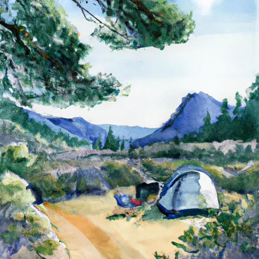
The campground includes 15 campsites, each equipped with picnic tables and fire rings. There are no hookups available, but potable water and vault toilets are provided. The campground operates on a first-come, first-served basis, so visitors are advised to arrive early to secure a site.
The area surrounding Symmes Creek Camping Area is known for its natural beauty, with the Sequoia trees, granite domes, and high mountain peaks. One quirky fact about the area is that it is home to the Western Bluebird, which is the state bird of California. The best time to visit the campground is during the summer months, between June and September, when temperatures range from the mid-70s to mid-80s Fahrenheit.
Overall, Symmes Creek Camping Area is an excellent choice for anyone looking for a peaceful getaway in a stunning natural setting. With its close proximity to several points of interest and the availability of basic amenities, it is a great option for both experienced and novice campers alike.
What's on-site at Symmes Creek
Key facilities Snoflo tracks for this campground. Confirm with the operator before booking -- amenities can change seasonally.
Plan your trip down to the hour
Same weather feed Snoflo's iOS app uses -- updated continuously from NOAA / yr.no.
Next 5 days, hour by hour
Temperature line with weather symbols on top, snow + rain accumulation as columns, humidity as a dotted line.
5-day forecast table
Every 3 hours, broken out across temperature, snow, rain, humidity, and wind. Each cell is colour-coded relative to the column min/max so trends jump out at a glance.
| Time | Condition | Temp (°F) | Snow (in) | Rain (in) | Humidity (%) | Wind (mps) | Wind dir |
|---|---|---|---|---|---|---|---|
| Loading detailed forecast… | |||||||
15-day temperature & precipitation
Daily temperatures, snow, and rain projected over the next two weeks. Hover any point for the full breakdown.
Other campgrounds in the area
Snoflo-tracked campsites within driving distance of Symmes Creek, with reservations status.
| Campground | Reservations | Toilets | View |
|---|---|---|---|
| Lower Grays Meadow Campground | ✓ | ✗ | → |
| Grays Meadow | ✓ | ✗ | → |
| Upper Grays Meadow Campground | ✓ | ✗ | → |
| Independence Creek | ✗ | ✓ | → |
| Independence Creek County Campground | ✗ | ✓ | → |
Nearby streamflow
USGS streamgauges within reach of Symmes Creek -- pulled live from the National Water Information System.
| Streamgauge | Discharge | View |
|---|---|---|
| Marble Fork Kaweah R Ab Horse C Nr Lodgepole Ca | 1 cfs | → |
| Sf Tule R Nr Cholollo Campground Nr Porterville Ca | 8 cfs | → |
| Sf Tule R Nr Reservation Bndry Nr Porterville Ca | 9 cfs | → |
Nearby snow depths
NRCS SNOTEL stations within reach of Symmes Creek -- relevant when planning a shoulder-season or alpine trip.
| SNOTEL station | Snowpack | 24h Snowfall | View |
|---|---|---|---|
| Charlotte Lake | 11.3 in | 0.0 in | → |
| Cottonwood Lakes | 0.0 in | 0.0 in | → |
| Blackcap Basin Goes | 0.0 in | 0.0 in | → |
| Nohrsc Casa Vieja Meadows | 169.8 in | 0.0 in | → |
| Beach Meadows | 0.0 in | 0.0 in | → |
| Upper Burnt Corral Meadow | 0.0 in | 0.0 in | → |
Plan a longer trip
The closest parks, lakes, boat launches, and paddle runs so a camping night can grow into a full weekend.
Parks
- Manzanar National Historic Site
- Wilderness John Muir
- Sierra National Forest
- Wilderness Monarch
- Wilderness Inyo Mountains
- Wilderness Jennie Lakes
Fishing spots
Camping essentials & Leave No Trace
- Pack it in, pack it out
- Take all trash, food scraps, and gear back with you to keep campsites clean and protect wildlife.
- Respect wildlife
- Observe animals from a distance, store food securely, and never feed wildlife to maintain natural behavior and safety.
- Know before you go
- Check weather, fire restrictions, trail conditions, and permit requirements to ensure a safe and well-planned trip.
- Minimize campfire impact
- Use established fire rings, keep fires small, fully extinguish them, or opt for a camp stove when fires are restricted.
- Leave what you find
- Preserve natural and cultural features by avoiding removal of plants, rocks, artifacts, or other elements of the environment.
Set push alerts in the Snoflo app
Save Symmes Creek as a favorite, set a custom threshold (precipitation, snowpack, freezing temperatures), and the iOS app will push the moment conditions cross.
About Symmes Creek
Can I make reservations at Symmes Creek?
This campground does not appear to accept reservations -- it's typically first-come, first-served. Arrive early on summer weekends.
How fresh is the weather data on this page?
The hourly forecast updates throughout the day from the NOAA / yr.no public feeds. Streamflow data is pulled live from USGS streamgauges and snowpack from the NRCS SNOTEL network.
What's the best time of year to visit?
Use the 15-day temperature & precipitation outlook on this page to plan -- pick a window with comfortable temperatures and low precipitation. For longer trips, the 5-day hourly meteogram shows snow + rain accumulation hour-by-hour.
How do I get to Symmes Creek?
Tap Directions in the hero above to open driving directions in Google Maps, or Open in map to center the Snoflo interactive map on the campground.
Can I get alerts when conditions change?
Yes -- alerts are managed through the Snoflo iOS app. Favorite this campground, set a threshold (temperature, snowpack, precipitation), and you'll get a push the moment it crosses.
Other campgrounds near here
Snoflo-tracked campgrounds within driving distance of Symmes Creek.