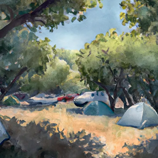
Walnut Camp Campground
Community Reviews
Been here? Share the conditions.
Reviews, ratings & photos are added in the free Snoflo iOS app — rate a spot, tag the conditions, and your visit is verified by location. Add or manage your reviews from the app.
Walnut Camp
The campground amenities include picnic tables, fire rings, and vault toilets. It operates on a first-come-first-serve basis and has 18 campsites available. It is important to note that there is no potable water available at the campground, so visitors are advised to bring their own or treat nearby water sources.
An interesting fact about the area is that it was named after the abundant walnut trees that used to grow in the area. Unfortunately, due to the destructive effects of bark beetles, the walnut trees are no longer present. However, the area is still known for its scenic beauty and wildlife.
The best time to visit Walnut Camp Camping Area is in the summer months, from May to September, when the average temperatures range from 60 to 80 degrees Fahrenheit during the day, dropping to the 40s and 50s at night. Visitors are advised to come prepared for the possibility of thunderstorms during the summer months. Overall, Walnut Camp Camping Area is an excellent place to experience the natural beauty of the Angeles National Forest and make lasting memories.
What's on-site at Walnut Camp
Key facilities Snoflo tracks for this campground. Confirm with the operator before booking -- amenities can change seasonally.
Plan your trip down to the hour
Same weather feed Snoflo's iOS app uses -- updated continuously from NOAA / yr.no.
Next 5 days, hour by hour
Temperature line with weather symbols on top, snow + rain accumulation as columns, humidity as a dotted line.
5-day forecast table
Every 3 hours, broken out across temperature, snow, rain, humidity, and wind. Each cell is colour-coded relative to the column min/max so trends jump out at a glance.
| Time | Condition | Temp (°F) | Snow (in) | Rain (in) | Humidity (%) | Wind (mps) | Wind dir |
|---|---|---|---|---|---|---|---|
| Loading detailed forecast… | |||||||
15-day temperature & precipitation
Daily temperatures, snow, and rain projected over the next two weeks. Hover any point for the full breakdown.
Other campgrounds in the area
Snoflo-tracked campsites within driving distance of Walnut Camp, with reservations status.
| Campground | Reservations | Toilets | View |
|---|---|---|---|
| Lodge Camp | ✗ | ✗ | → |
| Hollister Hills State Veh Rec Area | ✗ | ✓ | → |
| Bee Camp | ✗ | ✗ | → |
| Madrone Camp | ✗ | ✗ | → |
| Hudner Pass Camp | ✗ | ✗ | → |
Nearby streamflow
USGS streamgauges within reach of Walnut Camp -- pulled live from the National Water Information System.
| Streamgauge | Discharge | View |
|---|---|---|
| San Benito R A Hwy 156 Nr Hollister Ca | · | → |
| Tres Pinos C Nr Tres Pinos Ca | 5 cfs | → |
| Gabilan C Nr Salinas Ca | 0 cfs | → |
| Pajaro R A Chittenden Ca | 11 cfs | → |
| Pacheco C Nr Dunneville Ca | · | → |
| Llagas C Nr Gilroy | 11 cfs | → |
Plan a longer trip
The closest parks, lakes, boat launches, and paddle runs so a camping night can grow into a full weekend.
Parks
- Hollister Hills State Vehicular Recreation Area
- Fremont Peak State Park
- Rancho San Justo Park
- Dunne Park
- Vista Hill Park
- John Z. Hernandez Memorial Park
Boat launches
- Kirby Park
- Woodward Marine
- Pinto Lake City Park
- Coyote Lake Road 10700-12746, Gilroy
- Rountree Lane Santa Cruz County
- Coyote Lake County Park
Fishing spots
Points of interest
- Hollister Hills Svra Upper Ranch
- Upper Ranch Entrance
- Saddle Association Museum
- Zanetta House
- Old Livery Stables
- Old Mission Jail
Paddle runs
- Gold Creek To Three Pools (Opal Creek Run)
- Headwaters North Fork Little Sur To Boy Scout Camp
- Ventana Wilderness Boundary To Nf Boundary
- 0.25 Miles Downstream Of The Impoundment Of Sportsman's Lodge To Ventana Wilderness Boundary
- Boy Scout Camp To Confluence With Mainstem Little Sur
- 0.25 Milesupstram Of The Impoundment At Sportsman's Lodge To 0.25 Miles Downstream Of The Impoundment At Sportsman's Lodge
Camping essentials & Leave No Trace
- Pack it in, pack it out
- Take all trash, food scraps, and gear back with you to keep campsites clean and protect wildlife.
- Respect wildlife
- Observe animals from a distance, store food securely, and never feed wildlife to maintain natural behavior and safety.
- Know before you go
- Check weather, fire restrictions, trail conditions, and permit requirements to ensure a safe and well-planned trip.
- Minimize campfire impact
- Use established fire rings, keep fires small, fully extinguish them, or opt for a camp stove when fires are restricted.
- Leave what you find
- Preserve natural and cultural features by avoiding removal of plants, rocks, artifacts, or other elements of the environment.
Set push alerts in the Snoflo app
Save Walnut Camp as a favorite, set a custom threshold (precipitation, snowpack, freezing temperatures), and the iOS app will push the moment conditions cross.
About Walnut Camp
Can I make reservations at Walnut Camp?
This campground does not appear to accept reservations -- it's typically first-come, first-served. Arrive early on summer weekends.
How fresh is the weather data on this page?
The hourly forecast updates throughout the day from the NOAA / yr.no public feeds. Streamflow data is pulled live from USGS streamgauges and snowpack from the NRCS SNOTEL network.
What's the best time of year to visit?
Use the 15-day temperature & precipitation outlook on this page to plan -- pick a window with comfortable temperatures and low precipitation. For longer trips, the 5-day hourly meteogram shows snow + rain accumulation hour-by-hour.
How do I get to Walnut Camp?
Tap Directions in the hero above to open driving directions in Google Maps, or Open in map to center the Snoflo interactive map on the campground.
Can I get alerts when conditions change?
Yes -- alerts are managed through the Snoflo iOS app. Favorite this campground, set a threshold (temperature, snowpack, precipitation), and you'll get a push the moment it crosses.
Other campgrounds near here
Snoflo-tracked campgrounds within driving distance of Walnut Camp.