Vallecito campground
Community Reviews
Been here? Share the conditions.
Reviews, ratings & photos are added in the free Snoflo iOS app — rate a spot, tag the conditions, and your visit is verified by location. Add or manage your reviews from the app.
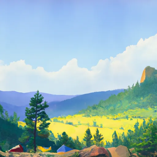
Vallecito
The campground has 80 campsites that are available on a first-come, first-serve basis. Each site has a picnic table and a fire pit. Restrooms and drinking water are also available for visitors. There are no RV hookups at this campground, but it can accommodate small RVs and trailers.
One quirky fact about the area is that it was once home to the Ute Indians, who believed that the Vallecito Lake was inhabited by a giant serpent.
The best time of year to visit Vallecito Camping Area is between June and September when the weather is mild and the average temperature is around 70 degrees Fahrenheit. However, visitors should be prepared for afternoon thunderstorms during the summer months.
In summary, Vallecito Camping Area is a beautiful and peaceful campground in the San Juan National Forest that offers stunning views of the surrounding mountains and forests. It is near popular fishing and boating destinations and the largest wilderness area in Colorado. The campground has 80 campsites available on a first-come, first-serve basis, and there are restrooms and drinking water available for visitors. One quirky fact about the area is that it was once believed to be inhabited by a giant serpent. The best time of year to visit is between June and September when the weather is mild and the average temperature is around 70 degrees Fahrenheit.
What's on-site at Vallecito
Key facilities Snoflo tracks for this campground. Confirm with the operator before booking -- amenities can change seasonally.
Plan your trip down to the hour
Same weather feed Snoflo's iOS app uses -- updated continuously from NOAA / yr.no.
Next 5 days, hour by hour
Temperature line with weather symbols on top, snow + rain accumulation as columns, humidity as a dotted line.
5-day forecast table
Every 3 hours, broken out across temperature, snow, rain, humidity, and wind. Each cell is colour-coded relative to the column min/max so trends jump out at a glance.
| Time | Condition | Temp (°F) | Snow (in) | Rain (in) | Humidity (%) | Wind (mps) | Wind dir |
|---|---|---|---|---|---|---|---|
| Loading detailed forecast… | |||||||
15-day temperature & precipitation
Daily temperatures, snow, and rain projected over the next two weeks. Hover any point for the full breakdown.
Other campgrounds in the area
Snoflo-tracked campsites within driving distance of Vallecito, with reservations status.
| Campground | Reservations | Toilets | View |
|---|---|---|---|
| Vallecito Campground | ✓ | ✗ | → |
| Pine River | ✗ | ✓ | → |
| Middle Mountain Campground | ✓ | ✗ | → |
| Middle Mountain - Vallecito Reservoir | ✗ | ✓ | → |
| Pine Point - Vallecito Reservoir | ✗ | ✓ | → |
Nearby streamflow
USGS streamgauges within reach of Vallecito -- pulled live from the National Water Information System.
| Streamgauge | Discharge | View |
|---|---|---|
| Vallecito Creek Near Bayfield | 27 cfs | → |
| Animas River Above Tacoma | 165 cfs | → |
| Florida R Bl Flor Farmers Ditch | 10 cfs | → |
| Los Pinos River Near Ignacio | 1 cfs | → |
| Animas River Below Silverton | 108 cfs | → |
| Animas River At Durango | 182 cfs | → |
Nearby snow depths
NRCS SNOTEL stations within reach of Vallecito -- relevant when planning a shoulder-season or alpine trip.
| SNOTEL station | Snowpack | 24h Snowfall | View |
|---|---|---|---|
| Nohrsc Vallecito | 5.0 in | 0.0 in | → |
| Vallecito | 4.0 in | 0.0 in | → |
| Stump Lakes | 0.0 in | 0.0 in | → |
| Stump Lakes | 0.0 in | 0.0 in | → |
| Bayfield 6.2 N | 0.0 in | 0.0 in | → |
| Bayfield 7n | 0.0 in | 0.0 in | → |
Plan a longer trip
The closest parks, lakes, boat launches, and paddle runs so a camping night can grow into a full weekend.
Parks
- Wilderness Hermosa Creek
- Memorial Park Phase One
- Janson Memorial Playground
- Memorial Park Phase Two
- Folsom Park
- Chapman Hill Ski Area
Boat launches
- Cr 243 La Plata County
- Haviland Lake State Wildlife Area
- Williams Creek Reservoir State Wildlife Area
- Pastorius Reservoir State Wildlife Area
Fishing spots
- Vallecito Reservoir
- Lemon Reservoir
- Elbert Creek
- Haviland Lake
- Teal Boat Ramp
- Williams Creek Reservoir
Points of interest
Paddle runs
- Confluence With Rincon La Vaca And North Fork To Northern Line Of Granite Peak Ranch
- Lake Creek--Headwaters To Confluence With Los Pinos
- Flint Creek--Headwaters To Confluence With Los Pinos
- Sierra Vandera--Headwaters To Confluence With Los Pinos
- Rincon La Osa--Headwaters To Confluence With Los Pinos
- Fdr 631 To Indian Creek
Camping essentials & Leave No Trace
- Pack it in, pack it out
- Take all trash, food scraps, and gear back with you to keep campsites clean and protect wildlife.
- Respect wildlife
- Observe animals from a distance, store food securely, and never feed wildlife to maintain natural behavior and safety.
- Know before you go
- Check weather, fire restrictions, trail conditions, and permit requirements to ensure a safe and well-planned trip.
- Minimize campfire impact
- Use established fire rings, keep fires small, fully extinguish them, or opt for a camp stove when fires are restricted.
- Leave what you find
- Preserve natural and cultural features by avoiding removal of plants, rocks, artifacts, or other elements of the environment.
Set push alerts in the Snoflo app
Save Vallecito as a favorite, set a custom threshold (precipitation, snowpack, freezing temperatures), and the iOS app will push the moment conditions cross.
About Vallecito
Can I make reservations at Vallecito?
This campground does not appear to accept reservations -- it's typically first-come, first-served. Arrive early on summer weekends.
How fresh is the weather data on this page?
The hourly forecast updates throughout the day from the NOAA / yr.no public feeds. Streamflow data is pulled live from USGS streamgauges and snowpack from the NRCS SNOTEL network.
What's the best time of year to visit?
Use the 15-day temperature & precipitation outlook on this page to plan -- pick a window with comfortable temperatures and low precipitation. For longer trips, the 5-day hourly meteogram shows snow + rain accumulation hour-by-hour.
How do I get to Vallecito?
Tap Directions in the hero above to open driving directions in Google Maps, or Open in map to center the Snoflo interactive map on the campground.
Can I get alerts when conditions change?
Yes -- alerts are managed through the Snoflo iOS app. Favorite this campground, set a threshold (temperature, snowpack, precipitation), and you'll get a push the moment it crosses.
Other campgrounds near here
Snoflo-tracked campgrounds within driving distance of Vallecito.