Zapata Falls Site 3 campground
Community Reviews
Been here? Share the conditions.
Reviews, ratings & photos are added in the free Snoflo iOS app — rate a spot, tag the conditions, and your visit is verified by location. Add or manage your reviews from the app.
Zapata Falls Site 3
The campground has 12 reservable sites, each with a parking pad, picnic table, and fire ring. There are also vault toilets and potable water available on-site. The fee for camping is $21 per night, and reservations can be made online.
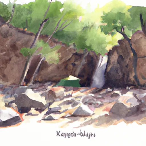
One of the main attractions of the area is Zapata Falls, a 30-foot waterfall located just a short hike from the campsite. The falls are particularly stunning in the early morning or late afternoon when the sun is low in the sky and casts a warm glow on the water.
Other nearby points of interest include the Great Sand Dunes National Park, which is just a short drive away, and the town of Alamosa, which has a variety of restaurants, shops, and museums.
The best time of year to visit the Zapata Falls Site 3 Campsite is in the summer months, between June and August, when the average temperature is in the mid-70s. However, the campground is open year-round, and visitors can enjoy snowshoeing and cross-country skiing in the winter months.
Overall, the Zapata Falls Site 3 Campsite is a beautiful and peaceful spot to camp, surrounded by stunning scenery and plenty of outdoor activities to enjoy.
What's on-site at Zapata Falls Site 3
Key facilities Snoflo tracks for this campground. Confirm with the operator before booking -- amenities can change seasonally.
Plan your trip down to the hour
Same weather feed Snoflo's iOS app uses -- updated continuously from NOAA / yr.no.
Next 5 days, hour by hour
Temperature line with weather symbols on top, snow + rain accumulation as columns, humidity as a dotted line.
5-day forecast table
Every 3 hours, broken out across temperature, snow, rain, humidity, and wind. Each cell is colour-coded relative to the column min/max so trends jump out at a glance.
| Time | Condition | Temp (°F) | Snow (in) | Rain (in) | Humidity (%) | Wind (mps) | Wind dir |
|---|---|---|---|---|---|---|---|
| Loading detailed forecast… | |||||||
15-day temperature & precipitation
Daily temperatures, snow, and rain projected over the next two weeks. Hover any point for the full breakdown.
Other campgrounds in the area
Snoflo-tracked campsites within driving distance of Zapata Falls Site 3, with reservations status.
| Campground | Reservations | Toilets | View |
|---|---|---|---|
| Saddle Mountain Free Campground | ✗ | ✗ | → |
| Saddle Mountain Rv Park | ✗ | ✗ | → |
| Mishroom Rhyolite | ✗ | ✗ | → |
| Buckeye Hills Co Park | ✗ | ✓ | → |
| Leaf Verde Rv Resort | ✗ | ✗ | → |
| Painted Rock | ✗ | ✓ | → |
Nearby streamflow
USGS streamgauges within reach of Zapata Falls Site 3 -- pulled live from the National Water Information System.
| Streamgauge | Discharge | View |
|---|---|---|
| Huerfano R At Manzanares Xing | 6 cfs | → |
| Ute Creek Near Fort Garland | 1 cfs | → |
| Sangre De Cristo Creek Near Fort Garland | 0 cfs | → |
| Trinchera Creek Below Smith Res | 0 cfs | → |
| Trinchera C Ab Mtn Home Re | 0 cfs | → |
| Rio Grande At Alamosa | 7 cfs | → |
Nearby snow depths
NRCS SNOTEL stations within reach of Zapata Falls Site 3 -- relevant when planning a shoulder-season or alpine trip.
| SNOTEL station | Snowpack | 24h Snowfall | View |
|---|---|---|---|
| Great Sand Dunes Natl Mon | 0.0 in | 0.0 in | → |
| Nohrsc Ute Creek | 0.0 in | 0.0 in | → |
| Ute Creek | 0.0 in | 0.0 in | → |
| Nohrsc Medano Pass | 1.0 in | 0.0 in | → |
| Medano Pass | 1.0 in | 0.0 in | → |
| Alamosa 1.1 N | 0.0 in | 0.0 in | → |
Plan a longer trip
The closest parks, lakes, boat launches, and paddle runs so a camping night can grow into a full weekend.
Camping essentials & Leave No Trace
- Pack it in, pack it out
- Take all trash, food scraps, and gear back with you to keep campsites clean and protect wildlife.
- Respect wildlife
- Observe animals from a distance, store food securely, and never feed wildlife to maintain natural behavior and safety.
- Know before you go
- Check weather, fire restrictions, trail conditions, and permit requirements to ensure a safe and well-planned trip.
- Minimize campfire impact
- Use established fire rings, keep fires small, fully extinguish them, or opt for a camp stove when fires are restricted.
- Leave what you find
- Preserve natural and cultural features by avoiding removal of plants, rocks, artifacts, or other elements of the environment.
Set push alerts in the Snoflo app
Save Zapata Falls Site 3 as a favorite, set a custom threshold (precipitation, snowpack, freezing temperatures), and the iOS app will push the moment conditions cross.
About Zapata Falls Site 3
Can I make reservations at Zapata Falls Site 3?
This campground does not appear to accept reservations -- it's typically first-come, first-served. Arrive early on summer weekends.
How fresh is the weather data on this page?
The hourly forecast updates throughout the day from the NOAA / yr.no public feeds. Streamflow data is pulled live from USGS streamgauges and snowpack from the NRCS SNOTEL network.
What's the best time of year to visit?
Use the 15-day temperature & precipitation outlook on this page to plan -- pick a window with comfortable temperatures and low precipitation. For longer trips, the 5-day hourly meteogram shows snow + rain accumulation hour-by-hour.
How do I get to Zapata Falls Site 3?
Tap Directions in the hero above to open driving directions in Google Maps, or Open in map to center the Snoflo interactive map on the campground.
Can I get alerts when conditions change?
Yes -- alerts are managed through the Snoflo iOS app. Favorite this campground, set a threshold (temperature, snowpack, precipitation), and you'll get a push the moment it crosses.
Other campgrounds near here
Snoflo-tracked campgrounds within driving distance of Zapata Falls Site 3.