Youth Camp I Campground
Community Reviews
Been here? Share the conditions.
Reviews, ratings & photos are added in the free Snoflo iOS app — rate a spot, tag the conditions, and your visit is verified by location. Add or manage your reviews from the app.
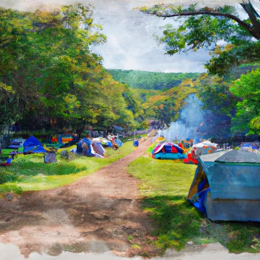
Youth Camp I
Reservations are recommended for Youth Camp I camping area to guarantee a spot, as it tends to get crowded during peak seasons. Campsites are allotted on a first-come, first-served basis, so planning ahead is advisable. The best time to visit this campground is during the warmer months, from late spring to early fall. The weather is pleasant during this time, allowing campers to indulge in outdoor activities like hiking, fishing, boating, and wildlife watching.
While enjoying the natural beauty and recreational opportunities, campers should be aware of a few things in the area. It is important to be cautious of wildlife encounters, particularly with bears, as they may be present in the surrounding woods. Proper food storage and waste disposal are essential to minimize the risk of attracting animals. Additionally, ticks are common in this region, so wearing insect repellent and checking for ticks after outdoor activities is recommended.
In conclusion, Youth Camp I camping area in Connecticut offers various amenities, including toilets, showers, picnic tables, and more. Reservations are advisable, especially during peak seasons. The best time to visit is during the warmer months, and campers should be cautious of wildlife encounters and tick bites. With its natural beauty and recreational opportunities, Youth Camp I is a fantastic choice for a camping adventure in Connecticut.
What's on-site at Youth Camp I
Key facilities Snoflo tracks for this campground. Confirm with the operator before booking -- amenities can change seasonally.
Plan your trip down to the hour
Same weather feed Snoflo's iOS app uses -- updated continuously from NOAA / yr.no.
Next 5 days, hour by hour
Temperature line with weather symbols on top, snow + rain accumulation as columns, humidity as a dotted line.
5-day forecast table
Every 3 hours, broken out across temperature, snow, rain, humidity, and wind. Each cell is colour-coded relative to the column min/max so trends jump out at a glance.
| Time | Condition | Temp (°F) | Snow (in) | Rain (in) | Humidity (%) | Wind (mps) | Wind dir |
|---|---|---|---|---|---|---|---|
| Loading detailed forecast… | |||||||
15-day temperature & precipitation
Daily temperatures, snow, and rain projected over the next two weeks. Hover any point for the full breakdown.
Other campgrounds in the area
Snoflo-tracked campsites within driving distance of Youth Camp I, with reservations status.
| Campground | Reservations | Toilets | View |
|---|---|---|---|
| Youth Camp Ii | ✗ | ✗ | → |
| Youth Camp Iii | ✗ | ✗ | → |
| Mountain Lakes Park | ✗ | ✗ | → |
| Kettletown State Park | ✓ | ✗ | → |
| Ward Pound Ridge Reservation | ✗ | ✗ | → |
Nearby streamflow
USGS streamgauges within reach of Youth Camp I -- pulled live from the National Water Information System.
| Streamgauge | Discharge | View |
|---|---|---|
| Saugatuck River Near Redding | 7 cfs | → |
| Ridgefield Brook At Shields Lane Nr Ridgefield | 2 cfs | → |
| Pootatuck R At Sandy Hook | 12 cfs | → |
| Still River At Route 7 At Brookfield Center | 52 cfs | → |
| Saugatuck R Nr Westport | 11 cfs | → |
| East Branch Croton River Near Putnam Lake Ny | 23 cfs | → |
Nearby snow depths
NRCS SNOTEL stations within reach of Youth Camp I -- relevant when planning a shoulder-season or alpine trip.
| SNOTEL station | Snowpack | 24h Snowfall | View |
|---|---|---|---|
| Bethel 3.5 Nne | 0.0 in | 0.0 in | → |
| Brookfield 3.3 Sse | 0.0 in | 0.0 in | → |
| Ridgefield 1.9 Sse | 0.0 in | 0.0 in | → |
| Shelton 1.3 W | 0.0 in | 0.0 in | → |
| New Milford 5.3 Ssw | 0.0 in | 0.0 in | → |
| New Canaan 1.9 Ene | 0.0 in | 0.0 in | → |
Plan a longer trip
The closest parks, lakes, boat launches, and paddle runs so a camping night can grow into a full weekend.
Parks
- Putnam Memorial State Park
- Collis P Huntington State Park
- Parloa Field
- Meckauer Park
- J F Roorke Field
- Tarrywile Park And Mansion
Boat launches
- Lake Kenosia
- Danbury Boat Launch
- Mamanasco Lake
- Candlewood Lake (Lattins Cove)
- Lake Lillinonah (Pond Brook)
- Marina
Fishing spots
Points of interest
- Redding Historical Society
- 3-Town Marker
- Seven Arts Gallery
- Made By Hand
- Everwonder Childrens Museum
- Burlingham House
Paddle runs
- Pond Downstream Of Shepaug Reservoir Dam, Marked By Service Road Bridge To Ends In Backwaters Of Lake Lillinonah, Near Roxbury Falls
- Begins Downstream Of The Borough Of Bantam, At Stoddard Road Bridge To The Confluence With The Shepaug River
- Kent Bridge To Boardman Bridge
- Begins Below The Tailrace Of The Lower Collinsville Dam To The Route 187 Bridge
- The Confluence With The Nepaug River To A Point 0.2 Miles Below The Lower Collinsville Dam Tailrace
- New Hartford/Canton Town Line To The Confluence With The Nepaug River
Camping essentials & Leave No Trace
- Pack it in, pack it out
- Take all trash, food scraps, and gear back with you to keep campsites clean and protect wildlife.
- Respect wildlife
- Observe animals from a distance, store food securely, and never feed wildlife to maintain natural behavior and safety.
- Know before you go
- Check weather, fire restrictions, trail conditions, and permit requirements to ensure a safe and well-planned trip.
- Minimize campfire impact
- Use established fire rings, keep fires small, fully extinguish them, or opt for a camp stove when fires are restricted.
- Leave what you find
- Preserve natural and cultural features by avoiding removal of plants, rocks, artifacts, or other elements of the environment.
Set push alerts in the Snoflo app
Save Youth Camp I as a favorite, set a custom threshold (precipitation, snowpack, freezing temperatures), and the iOS app will push the moment conditions cross.
About Youth Camp I
Can I make reservations at Youth Camp I?
This campground does not appear to accept reservations -- it's typically first-come, first-served. Arrive early on summer weekends.
How fresh is the weather data on this page?
The hourly forecast updates throughout the day from the NOAA / yr.no public feeds. Streamflow data is pulled live from USGS streamgauges and snowpack from the NRCS SNOTEL network.
What's the best time of year to visit?
Use the 15-day temperature & precipitation outlook on this page to plan -- pick a window with comfortable temperatures and low precipitation. For longer trips, the 5-day hourly meteogram shows snow + rain accumulation hour-by-hour.
How do I get to Youth Camp I?
Tap Directions in the hero above to open driving directions in Google Maps, or Open in map to center the Snoflo interactive map on the campground.
Can I get alerts when conditions change?
Yes -- alerts are managed through the Snoflo iOS app. Favorite this campground, set a threshold (temperature, snowpack, precipitation), and you'll get a push the moment it crosses.
Other campgrounds near here
Snoflo-tracked campgrounds within driving distance of Youth Camp I.