Camel Lake Recreation Area Campground
Community Reviews
Been here? Share the conditions.
Reviews, ratings & photos are added in the free Snoflo iOS app — rate a spot, tag the conditions, and your visit is verified by location. Add or manage your reviews from the app.
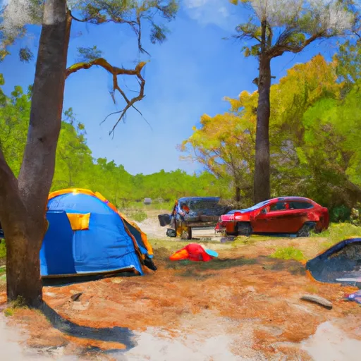
Camel Lake Recreation Area
Reservations are required at Camel Lake Recreation Area, and it is recommended to book well in advance due to its popularity. The campground offers both tent and RV camping options, accommodating a variety of camping needs. The friendly and knowledgeable staff is readily available to assist campers and ensure a pleasant stay.
The best time to visit Camel Lake Recreation Area is during the fall and spring seasons when the weather is mild and comfortable for outdoor activities. The campground is surrounded by beautiful nature trails and a picturesque lake, making it an ideal spot for hikers, birdwatchers, and fishing enthusiasts. However, it is important to be cautious of the wildlife in the area, including alligators and snakes. Visitors should adhere to safety guidelines and take appropriate precautions, such as keeping a safe distance from wildlife and properly securing food to avoid attracting animals. Overall, Camel Lake Recreation Area offers a fantastic camping experience with its amenities, natural beauty, and friendly staff, making it a must-visit destination for outdoor enthusiasts.
What's on-site at Camel Lake Recreation Area
Key facilities Snoflo tracks for this campground. Confirm with the operator before booking -- amenities can change seasonally.
Plan your trip down to the hour
Same weather feed Snoflo's iOS app uses -- updated continuously from NOAA / yr.no.
Next 5 days, hour by hour
Temperature line with weather symbols on top, snow + rain accumulation as columns, humidity as a dotted line.
5-day forecast table
Every 3 hours, broken out across temperature, snow, rain, humidity, and wind. Each cell is colour-coded relative to the column min/max so trends jump out at a glance.
| Time | Condition | Temp (°F) | Snow (in) | Rain (in) | Humidity (%) | Wind (mps) | Wind dir |
|---|---|---|---|---|---|---|---|
| Loading detailed forecast… | |||||||
15-day temperature & precipitation
Daily temperatures, snow, and rain projected over the next two weeks. Hover any point for the full breakdown.
Other campgrounds in the area
Snoflo-tracked campsites within driving distance of Camel Lake Recreation Area, with reservations status.
| Campground | Reservations | Toilets | View |
|---|---|---|---|
| Camel Lake | ✗ | ✗ | → |
| Camel Lake Recreation Area Apalachicola National Forest | ✗ | ✗ | → |
| Big Gully Landing | ✗ | ✗ | → |
| Florida River Island | ✗ | ✗ | → |
| Cliff Lake | ✗ | ✗ | → |
Nearby streamflow
USGS streamgauges within reach of Camel Lake Recreation Area -- pulled live from the National Water Information System.
| Streamgauge | Discharge | View |
|---|---|---|
| Apalachicola River Nr Blountstown | 11,500 cfs | → |
| Telogia Creek Nr Bristol | 85 cfs | → |
| Apalachicola R.Ab Chipola Conr Wewahitchka | 10,600 cfs | → |
| New River Nr Sumatra Fla | 237 cfs | → |
| Ochlockonee River Nr Smith Creek | 831 cfs | → |
| Chipola River Nr Altha | 1,080 cfs | → |
Nearby snow depths
NRCS SNOTEL stations within reach of Camel Lake Recreation Area -- relevant when planning a shoulder-season or alpine trip.
| SNOTEL station | Snowpack | 24h Snowfall | View |
|---|---|---|---|
| Fountain 3.4 Sse | 0.0 in | 0.0 in | → |
| Marianna 7 Ne | 6.0 in | 4.0 in | → |
| Lynn Haven 3.9 E | 0.0 in | 0.0 in | → |
| Havana 4.2 Sw | 0.0 in | 0.0 in | → |
| Marianna 0.8 Nne | 0.0 in | 0.0 in | → |
| Havana 5.5 Ne | 0.0 in | 0.0 in | → |
Plan a longer trip
The closest parks, lakes, boat launches, and paddle runs so a camping night can grow into a full weekend.
Parks
- Apalachicola Bluffs And Ravines Preserve
- Sam Atkins Park
- Beaverdam Creek Wildlife Management Area
- Torreya State Park
- Dead Lakes Park
- Lake Talquin State Forest
Boat launches
- Camel Lake Recreation Area - Apalachicola National Forest
- Sheep Island Pond Primitive Access
- Big Gully Landing And Campground
- Northwest Joe Red Shuler Road 7040, Bristol
- 188 Liberty County
- Scott's Ferry Landing
Fishing spots
Paddle runs
- Segment B--Sh 65 To Carr Bridge On Fh 13
- Segment C--Mud Swamp/New River Wilderness Boundary To Mud Swamp/New River Wilderness (Southern) Boundary
- 2 Miles Below Dam On Lake Talquin To Ochlockonee Bay
- Headwaters To Concrete Bridge (Burnt Bridge) On Fh 13 (Where River Enters Bradwell Ray Wilderness)
- Bradwell Bay Wilderness (Northern Boundary) To Bradwell Bay Wilderness Boundary At Trice Bridge On Fr 329
- Tirce Creek Bridge (Monkey Creek) To Forest Service Property Boundary In Sec 13
Camping essentials & Leave No Trace
- Pack it in, pack it out
- Take all trash, food scraps, and gear back with you to keep campsites clean and protect wildlife.
- Respect wildlife
- Observe animals from a distance, store food securely, and never feed wildlife to maintain natural behavior and safety.
- Know before you go
- Check weather, fire restrictions, trail conditions, and permit requirements to ensure a safe and well-planned trip.
- Minimize campfire impact
- Use established fire rings, keep fires small, fully extinguish them, or opt for a camp stove when fires are restricted.
- Leave what you find
- Preserve natural and cultural features by avoiding removal of plants, rocks, artifacts, or other elements of the environment.
Set push alerts in the Snoflo app
Save Camel Lake Recreation Area as a favorite, set a custom threshold (precipitation, snowpack, freezing temperatures), and the iOS app will push the moment conditions cross.
About Camel Lake Recreation Area
Can I make reservations at Camel Lake Recreation Area?
Yes -- this campground accepts reservations. Snoflo recommends booking early for peak season; check the operator (Recreation.gov / state park system / private operator) for the booking window and cancellation policy.
How fresh is the weather data on this page?
The hourly forecast updates throughout the day from the NOAA / yr.no public feeds. Streamflow data is pulled live from USGS streamgauges and snowpack from the NRCS SNOTEL network.
What's the best time of year to visit?
Use the 15-day temperature & precipitation outlook on this page to plan -- pick a window with comfortable temperatures and low precipitation. For longer trips, the 5-day hourly meteogram shows snow + rain accumulation hour-by-hour.
How do I get to Camel Lake Recreation Area?
Tap Directions in the hero above to open driving directions in Google Maps, or Open in map to center the Snoflo interactive map on the campground.
Can I get alerts when conditions change?
Yes -- alerts are managed through the Snoflo iOS app. Favorite this campground, set a threshold (temperature, snowpack, precipitation), and you'll get a push the moment it crosses.
Other campgrounds near here
Snoflo-tracked campgrounds within driving distance of Camel Lake Recreation Area.