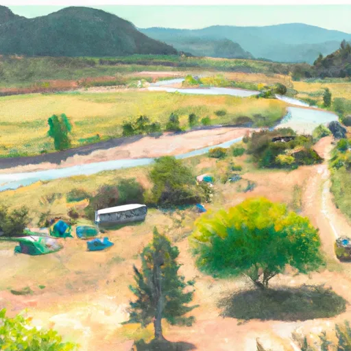
Confluence Campsite Campground
Community Reviews
Been here? Share the conditions.
Reviews, ratings & photos are added in the free Snoflo iOS app — rate a spot, tag the conditions, and your visit is verified by location. Add or manage your reviews from the app.
Confluence Campsite
The campground provides various amenities for campers, including clean drinking water, restrooms, picnic tables, and fire pits. These facilities make it a convenient option for both tent and RV camping. Additionally, some sources mention the availability of hiking trails nearby, allowing campers to explore the natural beauty of the area.
Reservations are accepted at Confluence Campsite, ensuring campers can secure their spot ahead of time. It is advisable to make reservations well in advance, especially during peak seasons, as this campground tends to attract a significant number of visitors.
The best time of year to visit Confluence Campsite is typically during the summer months, from June to September. During this time, the weather is pleasant, allowing campers to fully enjoy the outdoor activities and take in the breathtaking surroundings. However, it is always recommended to check the weather forecast before planning a trip to ensure a comfortable and safe camping experience.
While Confluence Campsite offers a serene setting for camping, it is important to be cautious of certain factors. Some sources mention that the area can be prone to insect activity, so campers should be prepared with appropriate bug repellent. Additionally, it is advisable to pack essential camping gear, including a first aid kit and proper clothing for changing weather conditions.
Overall, Confluence Campsite in Idaho is a well-equipped campground that offers a range of amenities for a comfortable camping experience. With its scenic location and availability of reservations, it is an ideal destination for nature enthusiasts seeking a peaceful getaway in the beautiful state of Idaho.
What's on-site at Confluence Campsite
Key facilities Snoflo tracks for this campground. Confirm with the operator before booking -- amenities can change seasonally.
Plan your trip down to the hour
Same weather feed Snoflo's iOS app uses -- updated continuously from NOAA / yr.no.
Next 5 days, hour by hour
Temperature line with weather symbols on top, snow + rain accumulation as columns, humidity as a dotted line.
5-day forecast table
Every 3 hours, broken out across temperature, snow, rain, humidity, and wind. Each cell is colour-coded relative to the column min/max so trends jump out at a glance.
| Time | Condition | Temp (°F) | Snow (in) | Rain (in) | Humidity (%) | Wind (mps) | Wind dir |
|---|---|---|---|---|---|---|---|
| Loading detailed forecast… | |||||||
15-day temperature & precipitation
Daily temperatures, snow, and rain projected over the next two weeks. Hover any point for the full breakdown.
Other campgrounds in the area
Snoflo-tracked campsites within driving distance of Confluence Campsite, with reservations status.
| Campground | Reservations | Toilets | View |
|---|---|---|---|
| Pulman Mine Campsite | ✗ | ✗ | → |
| Salmon Bar Campsite | ✗ | ✗ | → |
| Eye Of The Needle Campsite | ✗ | ✗ | → |
| Many Bedrooms Campsite | ✗ | ✗ | → |
| Buzzards Roost Campsite | ✗ | ✗ | → |
Nearby streamflow
USGS streamgauges within reach of Confluence Campsite -- pulled live from the National Water Information System.
| Streamgauge | Discharge | View |
|---|---|---|
| Snake River Bl Mcduff Rapids At China Gardens | 14,200 cfs | → |
| Snake River Near Anatone | 13,100 cfs | → |
| Imnaha River At Imnaha | 150 cfs | → |
| Salmon River At White Bird Id | 5,170 cfs | → |
| Grande Ronde River At Troy | 410 cfs | → |
| Webb Creek Near Sweetwater Id | -999,999 cfs | → |
Nearby snow depths
NRCS SNOTEL stations within reach of Confluence Campsite -- relevant when planning a shoulder-season or alpine trip.
| SNOTEL station | Snowpack | 24h Snowfall | View |
|---|---|---|---|
| Anatone 2.3 S | 0.0 in | 0.0 in | → |
| Lucile 1.2 Nne | 0.0 in | 0.0 in | → |
| Asotin 14 Sw | 0.0 in | 0.0 in | → |
| Grangeville 0.2 Ene | 0.0 in | 0.0 in | → |
| Nohrsc Sourdough Gulch | 0.0 in | 0.0 in | → |
| Sourdough Gulch | 0.0 in | 0.0 in | → |
Plan a longer trip
The closest parks, lakes, boat launches, and paddle runs so a camping night can grow into a full weekend.
Parks
- Fields Spring State Park
- Nez Perce National Historic Park-Confluence Overlook
- Winchester Lake State Park
- Vollmer Park
- Chief Looking Glass Park
- Hells Gate State Park
Boat launches
- Dug Bar
- Snake River Road Asotin County
- Heller Bar
- Soldiers Meadow Road Nez Perce County
- Pittsburg Landing Road Idaho County
- Center Creek Road Idaho County
Points of interest
- Buckhorn Tower Viewpoint
- Red Hill Lookout Viewpoint
- Cooper's Ferry / Nipéhe
- Five Mile Overlook
- Pittsburg Rockart Interpertive Site
- Joseph Canyon Viewpoint
Paddle runs
- The Northern Boundary Of The Wallowa-Whitman National Forest To The Confluence With The Grande Ronde River
- Joseph Creek
- Snake River - 4.01
- Grande Ronde River (Lower)
- The Confluence With The Grande Ronde River To Ends In The Slack Water Of The Lower Granite Reservoir, Located One Half Mile Above The Town Of Asotin, Washington
Camping essentials & Leave No Trace
- Pack it in, pack it out
- Take all trash, food scraps, and gear back with you to keep campsites clean and protect wildlife.
- Respect wildlife
- Observe animals from a distance, store food securely, and never feed wildlife to maintain natural behavior and safety.
- Know before you go
- Check weather, fire restrictions, trail conditions, and permit requirements to ensure a safe and well-planned trip.
- Minimize campfire impact
- Use established fire rings, keep fires small, fully extinguish them, or opt for a camp stove when fires are restricted.
- Leave what you find
- Preserve natural and cultural features by avoiding removal of plants, rocks, artifacts, or other elements of the environment.
Set push alerts in the Snoflo app
Save Confluence Campsite as a favorite, set a custom threshold (precipitation, snowpack, freezing temperatures), and the iOS app will push the moment conditions cross.
About Confluence Campsite
Can I make reservations at Confluence Campsite?
This campground does not appear to accept reservations -- it's typically first-come, first-served. Arrive early on summer weekends.
How fresh is the weather data on this page?
The hourly forecast updates throughout the day from the NOAA / yr.no public feeds. Streamflow data is pulled live from USGS streamgauges and snowpack from the NRCS SNOTEL network.
What's the best time of year to visit?
Use the 15-day temperature & precipitation outlook on this page to plan -- pick a window with comfortable temperatures and low precipitation. For longer trips, the 5-day hourly meteogram shows snow + rain accumulation hour-by-hour.
How do I get to Confluence Campsite?
Tap Directions in the hero above to open driving directions in Google Maps, or Open in map to center the Snoflo interactive map on the campground.
Can I get alerts when conditions change?
Yes -- alerts are managed through the Snoflo iOS app. Favorite this campground, set a threshold (temperature, snowpack, precipitation), and you'll get a push the moment it crosses.
Other campgrounds near here
Snoflo-tracked campgrounds within driving distance of Confluence Campsite.