Courtney Lake Campground
Community Reviews
Been here? Share the conditions.
Reviews, ratings & photos are added in the free Snoflo iOS app — rate a spot, tag the conditions, and your visit is verified by location. Add or manage your reviews from the app.
Courtney Lake
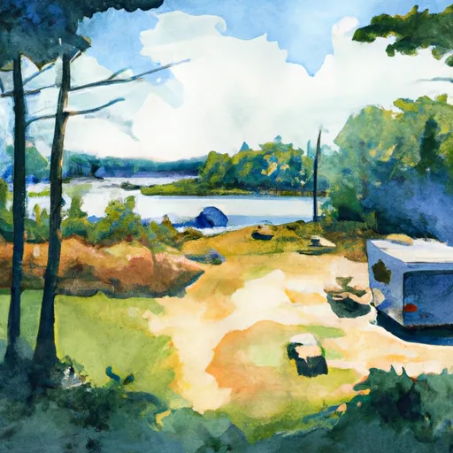
Reservations are accepted at Courtney Lake campground, allowing campers to secure their preferred dates and campsites in advance. This feature is especially beneficial during peak seasons when the campground tends to be busier. It is advisable to make reservations early to guarantee availability.
The best time to visit Courtney Lake camping area is during the summer months, from June to August, when the weather is pleasant, and outdoor activities flourish. The campground offers numerous recreational opportunities, including fishing, boating, and hiking, making it an ideal destination for nature enthusiasts. It is worth noting that the area is known for its abundance of mosquitoes, so campers should come prepared with insect repellent.
In conclusion, Courtney Lake camping area in Michigan provides campers with a range of amenities such as spacious campsites, clean restroom facilities, and the option for reservations. The best time to visit is during the summer months when outdoor activities are in full swing. However, visitors should be cautious of the mosquito population and ensure they have proper protection.
What's on-site at Courtney Lake
Key facilities Snoflo tracks for this campground. Confirm with the operator before booking -- amenities can change seasonally.
Plan your trip down to the hour
Same weather feed Snoflo's iOS app uses -- updated continuously from NOAA / yr.no.
Next 5 days, hour by hour
Temperature line with weather symbols on top, snow + rain accumulation as columns, humidity as a dotted line.
5-day forecast table
Every 3 hours, broken out across temperature, snow, rain, humidity, and wind. Each cell is colour-coded relative to the column min/max so trends jump out at a glance.
| Time | Condition | Temp (°F) | Snow (in) | Rain (in) | Humidity (%) | Wind (mps) | Wind dir |
|---|---|---|---|---|---|---|---|
| Loading detailed forecast… | |||||||
15-day temperature & precipitation
Daily temperatures, snow, and rain projected over the next two weeks. Hover any point for the full breakdown.
Other campgrounds in the area
Snoflo-tracked campsites within driving distance of Courtney Lake, with reservations status.
| Campground | Reservations | Toilets | View |
|---|---|---|---|
| Courtney Lake Campground | ✗ | ✗ | → |
| Bob Lake | ✗ | ✓ | → |
| Bob Lake Campground | ✗ | ✗ | → |
| Emily Lake State Forest | ✗ | ✓ | → |
| Emily Lake State Forest Campground | ✗ | ✗ | → |
Nearby streamflow
USGS streamgauges within reach of Courtney Lake -- pulled live from the National Water Information System.
| Streamgauge | Discharge | View |
|---|---|---|
| Ontonagon River Near Rockland | 494 cfs | → |
| Sturgeon River Near Alston | 161 cfs | → |
| Sturgeon River Near Sidnaw | 25 cfs | → |
| Bond Falls Canal Near Paulding | 91 cfs | → |
| Middle Branch Ontonagon River Near Paulding | 107 cfs | → |
| Silver River Near L'Anse | 26 cfs | → |
Nearby snow depths
NRCS SNOTEL stations within reach of Courtney Lake -- relevant when planning a shoulder-season or alpine trip.
| SNOTEL station | Snowpack | 24h Snowfall | View |
|---|---|---|---|
| Twin Lakes 0.2 Sw | 19.0 in | 1.4 in | → |
| Baraga 7nw | 0.0 in | 0.0 in | → |
| Nohrsc Ontonagon 1.8 Ese | 0.0 in | 0.0 in | → |
| Watton 2wsw | 0.0 in | 0.0 in | → |
| Covington | 0.0 in | 0.0 in | → |
| Painesdale | 0.0 in | 0.0 in | → |
Plan a longer trip
The closest parks, lakes, boat launches, and paddle runs so a camping night can grow into a full weekend.
Parks
- Wilderness Sturgeon River Gorge
- Baraga State Park
- Sturgeon River Sloughs State Wildlife Area
- Keweenaw National Historical Park
- Lake Gogebic State Park
- Mclain State Park
Boat launches
- Courtney Lake Bohemia Township
- Federal Forest Highway 16 Bohemia Township
- Bob Lake Road Laird Township
- Clear Lake Access Road Elm River Township
- Sandy Lake Access Road Elm River Township
- Pike Lake
Fishing spots
- Lake Roland (Twin Lakes)
- Rockland Pond
- Lake Gerald (Twin Lakes)
- Prickett Reservoir
- Otter Lake
- Alberta Pond
Points of interest
- Childhood Cottage Museum
- Old Victoria Historic Townsite
- Sandstone Falls
- Woas-Fm (Ontonagon)
- Agate Falls
- Ontonagon Lighthouse
Paddle runs
- South Branch,Confluence Of Cisco Branch And Tenmile Creek To Confluence With West Branch
- From Wagner Lake In Sec 13, T49n, R31w To Eastern Boundary Of The Ottawa Nf In Sec 12, T48n, R35@
- West Branch, Mi State Highway 28 To Cascade Falls
- West Branch Net River, From Its Source In Sec 35, T48n, R34w To Confluence With Mainstem Net River In Sec 24, T46n, R34w
- East Branch Net River, From Its Source In Sec 8, T47n, R32w To Confluence With Mainstem Net River In Sec 24, T46n, R34w
- Net River Mainstem, Confluence With East/West Branches To Confluence With The Mainstem Paint River
Camping essentials & Leave No Trace
- Pack it in, pack it out
- Take all trash, food scraps, and gear back with you to keep campsites clean and protect wildlife.
- Respect wildlife
- Observe animals from a distance, store food securely, and never feed wildlife to maintain natural behavior and safety.
- Know before you go
- Check weather, fire restrictions, trail conditions, and permit requirements to ensure a safe and well-planned trip.
- Minimize campfire impact
- Use established fire rings, keep fires small, fully extinguish them, or opt for a camp stove when fires are restricted.
- Leave what you find
- Preserve natural and cultural features by avoiding removal of plants, rocks, artifacts, or other elements of the environment.
Set push alerts in the Snoflo app
Save Courtney Lake as a favorite, set a custom threshold (precipitation, snowpack, freezing temperatures), and the iOS app will push the moment conditions cross.
About Courtney Lake
Can I make reservations at Courtney Lake?
This campground does not appear to accept reservations -- it's typically first-come, first-served. Arrive early on summer weekends.
How fresh is the weather data on this page?
The hourly forecast updates throughout the day from the NOAA / yr.no public feeds. Streamflow data is pulled live from USGS streamgauges and snowpack from the NRCS SNOTEL network.
What's the best time of year to visit?
Use the 15-day temperature & precipitation outlook on this page to plan -- pick a window with comfortable temperatures and low precipitation. For longer trips, the 5-day hourly meteogram shows snow + rain accumulation hour-by-hour.
How do I get to Courtney Lake?
Tap Directions in the hero above to open driving directions in Google Maps, or Open in map to center the Snoflo interactive map on the campground.
Can I get alerts when conditions change?
Yes -- alerts are managed through the Snoflo iOS app. Favorite this campground, set a threshold (temperature, snowpack, precipitation), and you'll get a push the moment it crosses.
Other campgrounds near here
Snoflo-tracked campgrounds within driving distance of Courtney Lake.