Wakpicada Natural Area campground
Community Reviews
Been here? Share the conditions.
Reviews, ratings & photos are added in the free Snoflo iOS app — rate a spot, tag the conditions, and your visit is verified by location. Add or manage your reviews from the app.
Wakpicada Natural Area
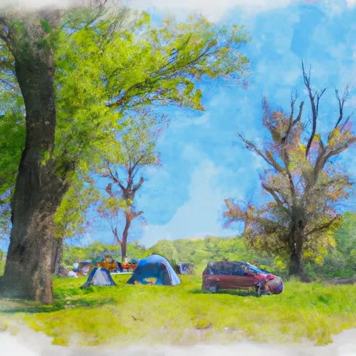
Wakpicada Natural Area campground amenities include primitive campsites, fire rings, and picnic tables. The camping area operates on a first-come, first-served basis with no reservations required. The campground features only five campsites, which makes it an ideal location for those looking for some peace and quiet.
One interesting fact about the area is that Wakpicada is actually a Sioux word meaning "crooked lake." The area was once used as a campground by the Sioux tribe and is now a popular spot for outdoor enthusiasts.
The best time to visit Wakpicada Natural Area is during the summer months when temperatures average around 80°F during the day and drop to the low 60s°F at night. The area experiences mild temperatures during the fall and spring months, making it an ideal location for camping and outdoor activities year-round.
What's on-site at Wakpicada Natural Area
Key facilities Snoflo tracks for this campground. Confirm with the operator before booking -- amenities can change seasonally.
Plan your trip down to the hour
Same weather feed Snoflo's iOS app uses -- updated continuously from NOAA / yr.no.
Next 5 days, hour by hour
Temperature line with weather symbols on top, snow + rain accumulation as columns, humidity as a dotted line.
5-day forecast table
Every 3 hours, broken out across temperature, snow, rain, humidity, and wind. Each cell is colour-coded relative to the column min/max so trends jump out at a glance.
| Time | Condition | Temp (°F) | Snow (in) | Rain (in) | Humidity (%) | Wind (mps) | Wind dir |
|---|---|---|---|---|---|---|---|
| Loading detailed forecast… | |||||||
15-day temperature & precipitation
Daily temperatures, snow, and rain projected over the next two weeks. Hover any point for the full breakdown.
Other campgrounds in the area
Snoflo-tracked campsites within driving distance of Wakpicada Natural Area, with reservations status.
| Campground | Reservations | Toilets | View |
|---|---|---|---|
| Group Campsite | ✗ | ✗ | → |
| Pack In Campsite #2 | ✗ | ✗ | → |
| Buffalo Creek County Park | ✗ | ✗ | → |
| Pack In Campsite #1 | ✗ | ✗ | → |
| Matsell Bridge Natural Area | ✗ | ✗ | → |
Nearby streamflow
USGS streamgauges within reach of Wakpicada Natural Area -- pulled live from the National Water Information System.
| Streamgauge | Discharge | View |
|---|---|---|
| Wapsipinicon River Near Anamosa | 2,930 cfs | → |
| Cedar River At Cedar Rapids | 27,500 cfs | → |
| Maquoketa River At Manchester | 318 cfs | → |
| Wapsipinicon River At Independence | 1,940 cfs | → |
| Iowa River Below Coralville Dam Nr Coralville | 4,150 cfs | → |
| Rapid Creek Near Iowa City | 11 cfs | → |
Nearby snow depths
NRCS SNOTEL stations within reach of Wakpicada Natural Area -- relevant when planning a shoulder-season or alpine trip.
| SNOTEL station | Snowpack | 24h Snowfall | View |
|---|---|---|---|
| Cedar Rapids No 1 | 0.0 in | 0.0 in | → |
| Anamosa 3 Ssw | 0.0 in | 0.0 in | → |
| Cedar Rapids 2.5 Wsw | 0.0 in | 0.0 in | → |
| Fairfax 4.0 Nw | 0.0 in | 0.0 in | → |
| Coralville 1.4 S | 0.0 in | 0.0 in | → |
| Iowa City | 0.0 in | 0.0 in | → |
Plan a longer trip
The closest parks, lakes, boat launches, and paddle runs so a camping night can grow into a full weekend.
Parks
- Brendel Park Playground
- Pinicon Ridge County Park
- Wakpicada Natural Area
- Matsell Bridge Natural Area
- Joe Emmons Memorial Park
- Willowwood Park
Boat launches
- Central City Road Central City
- Wakpicada Trail Linn County
- Central City Trail Central City
- Central City Trail Linn County
Fishing spots
Camping essentials & Leave No Trace
- Pack it in, pack it out
- Take all trash, food scraps, and gear back with you to keep campsites clean and protect wildlife.
- Respect wildlife
- Observe animals from a distance, store food securely, and never feed wildlife to maintain natural behavior and safety.
- Know before you go
- Check weather, fire restrictions, trail conditions, and permit requirements to ensure a safe and well-planned trip.
- Minimize campfire impact
- Use established fire rings, keep fires small, fully extinguish them, or opt for a camp stove when fires are restricted.
- Leave what you find
- Preserve natural and cultural features by avoiding removal of plants, rocks, artifacts, or other elements of the environment.
Set push alerts in the Snoflo app
Save Wakpicada Natural Area as a favorite, set a custom threshold (precipitation, snowpack, freezing temperatures), and the iOS app will push the moment conditions cross.
About Wakpicada Natural Area
Can I make reservations at Wakpicada Natural Area?
This campground does not appear to accept reservations -- it's typically first-come, first-served. Arrive early on summer weekends.
How fresh is the weather data on this page?
The hourly forecast updates throughout the day from the NOAA / yr.no public feeds. Streamflow data is pulled live from USGS streamgauges and snowpack from the NRCS SNOTEL network.
What's the best time of year to visit?
Use the 15-day temperature & precipitation outlook on this page to plan -- pick a window with comfortable temperatures and low precipitation. For longer trips, the 5-day hourly meteogram shows snow + rain accumulation hour-by-hour.
How do I get to Wakpicada Natural Area?
Tap Directions in the hero above to open driving directions in Google Maps, or Open in map to center the Snoflo interactive map on the campground.
Can I get alerts when conditions change?
Yes -- alerts are managed through the Snoflo iOS app. Favorite this campground, set a threshold (temperature, snowpack, precipitation), and you'll get a push the moment it crosses.
Other campgrounds near here
Snoflo-tracked campgrounds within driving distance of Wakpicada Natural Area.