Camp Cadiz Campground Campground
Community Reviews
Been here? Share the conditions.
Reviews, ratings & photos are added in the free Snoflo iOS app — rate a spot, tag the conditions, and your visit is verified by location. Add or manage your reviews from the app.
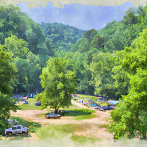
Camp Cadiz Campground
Reservations are accepted at Camp Cadiz Campground, ensuring campers can secure a spot in advance. It is advisable to make reservations, especially during peak seasons, to guarantee availability. As for the best time to visit, the campground is open year-round, but the months of spring and fall are particularly favorable due to milder temperatures and less crowded conditions.
Camp Cadiz Campground is a gateway to numerous outdoor activities and attractions. The campground is situated near the beautiful Land Between the Lakes National Recreation Area, offering opportunities for hiking, fishing, and wildlife viewing. It is important to note that the camping area is situated close to water bodies, so caution must be exercised to prevent accidents, particularly for families with young children. Additionally, campers are encouraged to practice Leave No Trace principles to preserve the natural environment and respect the campground's rules and regulations.
What's on-site at Camp Cadiz Campground
Key facilities Snoflo tracks for this campground. Confirm with the operator before booking -- amenities can change seasonally.
Plan your trip down to the hour
Same weather feed Snoflo's iOS app uses -- updated continuously from NOAA / yr.no.
Next 5 days, hour by hour
Temperature line with weather symbols on top, snow + rain accumulation as columns, humidity as a dotted line.
5-day forecast table
Every 3 hours, broken out across temperature, snow, rain, humidity, and wind. Each cell is colour-coded relative to the column min/max so trends jump out at a glance.
| Time | Condition | Temp (°F) | Snow (in) | Rain (in) | Humidity (%) | Wind (mps) | Wind dir |
|---|---|---|---|---|---|---|---|
| Loading detailed forecast… | |||||||
15-day temperature & precipitation
Daily temperatures, snow, and rain projected over the next two weeks. Hover any point for the full breakdown.
Other campgrounds in the area
Snoflo-tracked campsites within driving distance of Camp Cadiz Campground, with reservations status.
| Campground | Reservations | Toilets | View |
|---|---|---|---|
| Pine Ridge Campground | ✗ | ✗ | → |
| High Knob Campground | ✗ | ✗ | → |
| Pharaoh Campground | ✗ | ✗ | → |
| Tower Rock Campsite | ✗ | ✗ | → |
| Cave In Rock State Park Rv Site | ✗ | ✗ | → |
Nearby streamflow
USGS streamgauges within reach of Camp Cadiz Campground -- pulled live from the National Water Information System.
| Streamgauge | Discharge | View |
|---|---|---|
| Ohio River At Old Shawneetown | 104,000 cfs | → |
| Lusk Creek Near Eddyville | 4 cfs | → |
| South Fork Saline River Nr Carrier Mills | 45 cfs | → |
| Little Wabash River At Carmi | 760 cfs | → |
| Tradewater River At Olney | 99 cfs | → |
| Crab Orchard Creek Near Marion | 2 cfs | → |
Nearby snow depths
NRCS SNOTEL stations within reach of Camp Cadiz Campground -- relevant when planning a shoulder-season or alpine trip.
| SNOTEL station | Snowpack | 24h Snowfall | View |
|---|---|---|---|
| New Burnside 1.8 Ene | 0.0 in | 0.0 in | → |
Plan a longer trip
The closest parks, lakes, boat launches, and paddle runs so a camping night can grow into a full weekend.
Parks
- Cave In Rock State Park
- Wilderness Garden Of The Gods
- Nature Preserve Lusk Creek Canyon
- Wilderness Lusk Creek
- Wilderness Bay Creek
- Higginson-Henry Wildlife Management Area
Boat launches
- Tower Rock Road Hardin County
- Hardin County
- Water Street Cave-In-Rock
- Cave-In-Rock
- Front Street Elizabethtown
- Caseyville
Fishing spots
- Lake Tecumseh
- Whoopie Cat Lake
- One Horse Gap Lake
- Lake Of Egypt
- Little Cache Lake #1 (Bowman Lake)
- Dutchman Lake
Points of interest
Paddle runs
- Russell Cemetery, Approx 1/4 Mile North Of Karbers Ridge Road To Proclamation Boundary, 1 Mile Nw Of Elizabethtown,Il
- Wallace Cemetery Approx 2.5 Miles Nw Of Herod, Il To Confluence With Ohio River At Golconda Jobs Corp Center
- Source, About 2 Miles East Of Delwood, Il (Sec 10, T11s, R6e) To Bridge At Eddyville Blacktop (Se1/4,Sec.16,T12s, R6e)
- Bridge At Eddyville Blacktop To Confluence With Ohio River At Golconda,Il
- 1 Minle Southwest Of Delwood, Il (Sec. 18, T11s, R13e) To Reesville, 1/4 Mile South Of The Confluence With Sugar Creek
Camping essentials & Leave No Trace
- Pack it in, pack it out
- Take all trash, food scraps, and gear back with you to keep campsites clean and protect wildlife.
- Respect wildlife
- Observe animals from a distance, store food securely, and never feed wildlife to maintain natural behavior and safety.
- Know before you go
- Check weather, fire restrictions, trail conditions, and permit requirements to ensure a safe and well-planned trip.
- Minimize campfire impact
- Use established fire rings, keep fires small, fully extinguish them, or opt for a camp stove when fires are restricted.
- Leave what you find
- Preserve natural and cultural features by avoiding removal of plants, rocks, artifacts, or other elements of the environment.
Set push alerts in the Snoflo app
Save Camp Cadiz Campground as a favorite, set a custom threshold (precipitation, snowpack, freezing temperatures), and the iOS app will push the moment conditions cross.
About Camp Cadiz Campground
Can I make reservations at Camp Cadiz Campground?
Yes -- this campground accepts reservations. Snoflo recommends booking early for peak season; check the operator (Recreation.gov / state park system / private operator) for the booking window and cancellation policy.
How fresh is the weather data on this page?
The hourly forecast updates throughout the day from the NOAA / yr.no public feeds. Streamflow data is pulled live from USGS streamgauges and snowpack from the NRCS SNOTEL network.
What's the best time of year to visit?
Use the 15-day temperature & precipitation outlook on this page to plan -- pick a window with comfortable temperatures and low precipitation. For longer trips, the 5-day hourly meteogram shows snow + rain accumulation hour-by-hour.
How do I get to Camp Cadiz Campground?
Tap Directions in the hero above to open driving directions in Google Maps, or Open in map to center the Snoflo interactive map on the campground.
Can I get alerts when conditions change?
Yes -- alerts are managed through the Snoflo iOS app. Favorite this campground, set a threshold (temperature, snowpack, precipitation), and you'll get a push the moment it crosses.
Other campgrounds near here
Snoflo-tracked campgrounds within driving distance of Camp Cadiz Campground.