Esker Campsite Campground
Community Reviews
Been here? Share the conditions.
Reviews, ratings & photos are added in the free Snoflo iOS app — rate a spot, tag the conditions, and your visit is verified by location. Add or manage your reviews from the app.
Esker Campsite
The surrounding views of the area are stunning, with the esker offering a great vantage point to view the surrounding wilderness of the park. From the campsite, visitors can also enjoy views of the nearby mountain peaks and Nesowadnehunk Lake.
There are several nearby points of interest for visitors to explore. The nearby Sandy Stream Pond is a popular spot for fishing and canoeing. The Appalachian Trail runs nearby and visitors can hike a portion of the trail. There are also several hiking trails nearby, including the Mount Coe Trail and the Doubletop Mountain Trail.
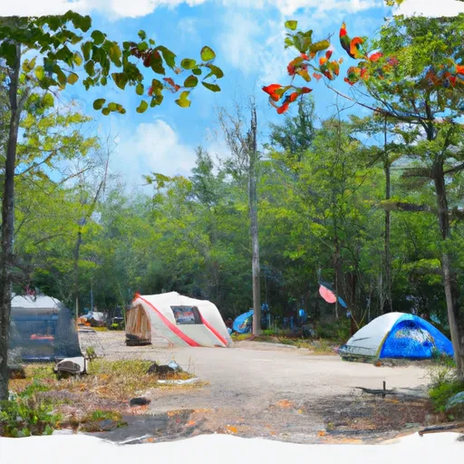
The Esker Campsite offers several amenities for campers, including fire pits, picnic tables, and tent platforms. There is no running water or electricity at the site, but visitors can purchase firewood and drinking water at a nearby ranger station.
Interesting facts about the area include the fact that the esker was formed by the last glacier that covered the area, which melted approximately 11,000 years ago. Baxter State Park is also home to the highest peak in Maine, Mount Katahdin.
The best time of year to visit the Esker Campsite is between May and October when the weather is mild. Average temperatures during this time range from the mid-60s to low 70s during the day and drop to the 40s at night. It is recommended to make reservations in advance as the campground can fill up quickly during peak season.
What's on-site at Esker Campsite
Key facilities Snoflo tracks for this campground. Confirm with the operator before booking -- amenities can change seasonally.
Plan your trip down to the hour
Same weather feed Snoflo's iOS app uses -- updated continuously from NOAA / yr.no.
Next 5 days, hour by hour
Temperature line with weather symbols on top, snow + rain accumulation as columns, humidity as a dotted line.
5-day forecast table
Every 3 hours, broken out across temperature, snow, rain, humidity, and wind. Each cell is colour-coded relative to the column min/max so trends jump out at a glance.
| Time | Condition | Temp (°F) | Snow (in) | Rain (in) | Humidity (%) | Wind (mps) | Wind dir |
|---|---|---|---|---|---|---|---|
| Loading detailed forecast… | |||||||
15-day temperature & precipitation
Daily temperatures, snow, and rain projected over the next two weeks. Hover any point for the full breakdown.
Other campgrounds in the area
Snoflo-tracked campsites within driving distance of Esker Campsite, with reservations status.
| Campground | Reservations | Toilets | View |
|---|---|---|---|
| Katahdin Esker Campsite | ✗ | ✗ | → |
| Big Seboeis | ✗ | ✗ | → |
| Lunksoos Group Site 7 | ✗ | ✗ | → |
| Sandbank Stream Campground | ✗ | ✗ | → |
| Lunksoos Campsite 5 | ✗ | ✗ | → |
Nearby streamflow
USGS streamgauges within reach of Esker Campsite -- pulled live from the National Water Information System.
| Streamgauge | Discharge | View |
|---|---|---|
| East Branch Penobscot River At Grindstone | 556 cfs | → |
| Seboeis River Near Shin Pond | 30 cfs | → |
| Mattawamkeag River Near Mattawamkeag | 266 cfs | → |
| Meduxnekeag R Above S Br Medux. R Nr Houlton | 18 cfs | → |
| Meduxnekeag River Near Houlton | 222 cfs | → |
| Aroostook River Near Masardis | 243 cfs | → |
Plan a longer trip
The closest parks, lakes, boat launches, and paddle runs so a camping night can grow into a full weekend.
Parks
Boat launches
- Lunkasoo Road Penobscot County
- Sherman Lumber Co Road Penobscot County
- Fredericka's Way Maine
- Golden Road Maine
- Grand Lake Road Penobscot County
- Debsconeag Deadwater
Points of interest
- Fire Lookout
- Last Katahdin View
- Scenic Overlook-Katahdin Loop
- Lumbermen's Museum
- Millinocket Contact Station
- William Sewall House
Paddle runs
- Bowlin Camps To Hay Brook
- Hay Brook To Bridge Above Medway At State Route 157
- Headwaters To Confluence With West Branch Penobscot River
- Headwaters To Confluence With Penobscot River, East Branch
- Ambajejus Falls To The End Of North And South Twin Lakes
- Grand Lake Matagamon To Bowlin Camps
Camping essentials & Leave No Trace
- Pack it in, pack it out
- Take all trash, food scraps, and gear back with you to keep campsites clean and protect wildlife.
- Respect wildlife
- Observe animals from a distance, store food securely, and never feed wildlife to maintain natural behavior and safety.
- Know before you go
- Check weather, fire restrictions, trail conditions, and permit requirements to ensure a safe and well-planned trip.
- Minimize campfire impact
- Use established fire rings, keep fires small, fully extinguish them, or opt for a camp stove when fires are restricted.
- Leave what you find
- Preserve natural and cultural features by avoiding removal of plants, rocks, artifacts, or other elements of the environment.
Set push alerts in the Snoflo app
Save Esker Campsite as a favorite, set a custom threshold (precipitation, snowpack, freezing temperatures), and the iOS app will push the moment conditions cross.
About Esker Campsite
Can I make reservations at Esker Campsite?
This campground does not appear to accept reservations -- it's typically first-come, first-served. Arrive early on summer weekends.
How fresh is the weather data on this page?
The hourly forecast updates throughout the day from the NOAA / yr.no public feeds. Streamflow data is pulled live from USGS streamgauges and snowpack from the NRCS SNOTEL network.
What's the best time of year to visit?
Use the 15-day temperature & precipitation outlook on this page to plan -- pick a window with comfortable temperatures and low precipitation. For longer trips, the 5-day hourly meteogram shows snow + rain accumulation hour-by-hour.
How do I get to Esker Campsite?
Tap Directions in the hero above to open driving directions in Google Maps, or Open in map to center the Snoflo interactive map on the campground.
Can I get alerts when conditions change?
Yes -- alerts are managed through the Snoflo iOS app. Favorite this campground, set a threshold (temperature, snowpack, precipitation), and you'll get a push the moment it crosses.
Other campgrounds near here
Snoflo-tracked campgrounds within driving distance of Esker Campsite.