South Branch Pond - Baxter State Park Campground
Community Reviews
Been here? Share the conditions.
Reviews, ratings & photos are added in the free Snoflo iOS app — rate a spot, tag the conditions, and your visit is verified by location. Add or manage your reviews from the app.
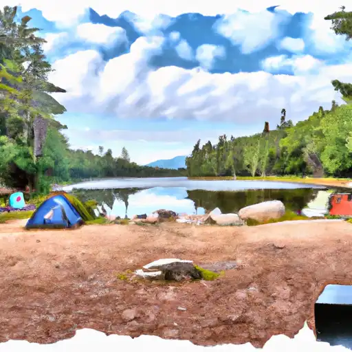
South Branch Pond - Baxter State Park
Reservations are required for camping at South Branch Pond, and they can be made online through the Baxter State Park website. It is advised to book well in advance, especially during peak season, as this campground is popular among outdoor enthusiasts. The best time to visit South Branch Pond is during the summer months, from June to September, when the weather is generally mild and the campground is fully operational.
While exploring the camping area, campers will be captivated by the stunning views of South Branch Pond and the surrounding mountains. Hiking enthusiasts can embark on the challenging but rewarding hike to the summit of Mount Katahdin, the highest peak in Maine. It is important to be cautious of wildlife in the area, such as black bears, and to properly store food to avoid attracting them. Campers must also adhere to the park's strict regulations, including the Leave No Trace principles, to preserve the natural beauty of South Branch Pond and ensure an enjoyable experience for all.
What's on-site at South Branch Pond - Baxter State Park
Key facilities Snoflo tracks for this campground. Confirm with the operator before booking -- amenities can change seasonally.
Plan your trip down to the hour
Same weather feed Snoflo's iOS app uses -- updated continuously from NOAA / yr.no.
Next 5 days, hour by hour
Temperature line with weather symbols on top, snow + rain accumulation as columns, humidity as a dotted line.
5-day forecast table
Every 3 hours, broken out across temperature, snow, rain, humidity, and wind. Each cell is colour-coded relative to the column min/max so trends jump out at a glance.
| Time | Condition | Temp (°F) | Snow (in) | Rain (in) | Humidity (%) | Wind (mps) | Wind dir |
|---|---|---|---|---|---|---|---|
| Loading detailed forecast… | |||||||
15-day temperature & precipitation
Daily temperatures, snow, and rain projected over the next two weeks. Hover any point for the full breakdown.
Other campgrounds in the area
Snoflo-tracked campsites within driving distance of South Branch Pond - Baxter State Park, with reservations status.
| Campground | Reservations | Toilets | View |
|---|---|---|---|
| South Branch Pond Campground | ✗ | ✗ | → |
| Lower Fowler Outlet Tentsite | ✗ | ✗ | → |
| Lower Fowler Pond Tentsite | ✗ | ✗ | → |
| Middle Fowler North Tentsite | ✗ | ✗ | → |
| Middle Fowler South Tentsite | ✗ | ✗ | → |
Nearby streamflow
USGS streamgauges within reach of South Branch Pond - Baxter State Park -- pulled live from the National Water Information System.
| Streamgauge | Discharge | View |
|---|---|---|
| Seboeis River Near Shin Pond | 21 cfs | → |
| East Branch Penobscot River At Grindstone | 521 cfs | → |
| Aroostook River Near Masardis | 246 cfs | → |
| Meduxnekeag R Above S Br Medux. R Nr Houlton | 14 cfs | → |
| Meduxnekeag River Near Houlton | 222 cfs | → |
| Mattawamkeag River Near Mattawamkeag | 188 cfs | → |
Plan a longer trip
The closest parks, lakes, boat launches, and paddle runs so a camping night can grow into a full weekend.
Boat launches
- Its 85 Penobscot County
- Grand Lake Road Piscataquis County
- Grand Lake Road Penobscot County
- Scraggly Lake
- Sawtelle Deadwater
- Chamberlain Lake
Points of interest
- Fire Lookout
- Last Katahdin View
- Scenic Overlook-Katahdin Loop
- Lumbermen's Museum
- Nahmakanta Lake Wilderness Camp
- William Sewall House
Paddle runs
- Grand Lake Matagamon To Bowlin Camps
- Bowlin Camps To Hay Brook
- Headwaters To Confluence With Penobscot River, East Branch
- Headwaters To Confluence With Penobscot River, East Branch
- Headwaters To Confluence With West Branch Penobscot River
- Ambajejus Falls To The End Of North And South Twin Lakes
Camping essentials & Leave No Trace
- Pack it in, pack it out
- Take all trash, food scraps, and gear back with you to keep campsites clean and protect wildlife.
- Respect wildlife
- Observe animals from a distance, store food securely, and never feed wildlife to maintain natural behavior and safety.
- Know before you go
- Check weather, fire restrictions, trail conditions, and permit requirements to ensure a safe and well-planned trip.
- Minimize campfire impact
- Use established fire rings, keep fires small, fully extinguish them, or opt for a camp stove when fires are restricted.
- Leave what you find
- Preserve natural and cultural features by avoiding removal of plants, rocks, artifacts, or other elements of the environment.
Set push alerts in the Snoflo app
Save South Branch Pond - Baxter State Park as a favorite, set a custom threshold (precipitation, snowpack, freezing temperatures), and the iOS app will push the moment conditions cross.
About South Branch Pond - Baxter State Park
Can I make reservations at South Branch Pond - Baxter State Park?
Yes -- this campground accepts reservations. Snoflo recommends booking early for peak season; check the operator (Recreation.gov / state park system / private operator) for the booking window and cancellation policy.
How fresh is the weather data on this page?
The hourly forecast updates throughout the day from the NOAA / yr.no public feeds. Streamflow data is pulled live from USGS streamgauges and snowpack from the NRCS SNOTEL network.
What's the best time of year to visit?
Use the 15-day temperature & precipitation outlook on this page to plan -- pick a window with comfortable temperatures and low precipitation. For longer trips, the 5-day hourly meteogram shows snow + rain accumulation hour-by-hour.
How do I get to South Branch Pond - Baxter State Park?
Tap Directions in the hero above to open driving directions in Google Maps, or Open in map to center the Snoflo interactive map on the campground.
Can I get alerts when conditions change?
Yes -- alerts are managed through the Snoflo iOS app. Favorite this campground, set a threshold (temperature, snowpack, precipitation), and you'll get a push the moment it crosses.
Other campgrounds near here
Snoflo-tracked campgrounds within driving distance of South Branch Pond - Baxter State Park.