Twelve Foot Falls County Park campground
Community Reviews
Been here? Share the conditions.
Reviews, ratings & photos are added in the free Snoflo iOS app — rate a spot, tag the conditions, and your visit is verified by location. Add or manage your reviews from the app.
Twelve Foot Falls County Park
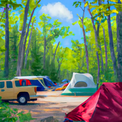
There are several nearby points of interest including the Nicolet National Forest, which offers hiking, fishing and hunting opportunities, and the Peshtigo River, which is a popular spot for kayaking and tubing. The campground amenities include pit toilets, picnic tables, fire rings, and drinking water. The camping area operates on a first-come-first-serve basis and has a total of 23 campsites available.
An interesting fact about the area is that it was once home to the Menominee Indian Tribe, who used the falls as a fishing spot. The best time to visit is during the summer months, from June to August, with average temperatures ranging from 70-80°F.
Overall, the Twelve Foot Falls County Park camping area provides a peaceful and secluded camping experience with stunning views of the waterfall and surrounding forest. It is a great destination for nature lovers and outdoor enthusiasts looking for a relaxing getaway.
What's on-site at Twelve Foot Falls County Park
Key facilities Snoflo tracks for this campground. Confirm with the operator before booking -- amenities can change seasonally.
Plan your trip down to the hour
Same weather feed Snoflo's iOS app uses -- updated continuously from NOAA / yr.no.
Next 5 days, hour by hour
Temperature line with weather symbols on top, snow + rain accumulation as columns, humidity as a dotted line.
5-day forecast table
Every 3 hours, broken out across temperature, snow, rain, humidity, and wind. Each cell is colour-coded relative to the column min/max so trends jump out at a glance.
| Time | Condition | Temp (°F) | Snow (in) | Rain (in) | Humidity (%) | Wind (mps) | Wind dir |
|---|---|---|---|---|---|---|---|
| Loading detailed forecast… | |||||||
15-day temperature & precipitation
Daily temperatures, snow, and rain projected over the next two weeks. Hover any point for the full breakdown.
Other campgrounds in the area
Snoflo-tracked campsites within driving distance of Twelve Foot Falls County Park, with reservations status.
| Campground | Reservations | Toilets | View |
|---|---|---|---|
| New Prospect - Kettle Moraine State Forest | ✓ | ✗ | → |
| Goodman County Park | ✗ | ✗ | → |
| Mcclintock County Park | ✗ | ✗ | → |
| Silver Cliff Camp | ✗ | ✗ | → |
| Old Veterans State Camp Ground | ✗ | ✗ | → |
Nearby streamflow
USGS streamgauges within reach of Twelve Foot Falls County Park -- pulled live from the National Water Information System.
| Streamgauge | Discharge | View |
|---|---|---|
| Pike River At Amberg | 127 cfs | → |
| Menominee River At Niagara | 1,340 cfs | → |
| Peshtigo River Near Wabeno | 234 cfs | → |
| Menominee River Below Pemene Creek Near Pembine | 1,780 cfs | → |
| Menominee River Near Vulcan | 1,870 cfs | → |
| Menominee River At White Rapids Dam Near Banat | 1,680 cfs | → |
Nearby snow depths
NRCS SNOTEL stations within reach of Twelve Foot Falls County Park -- relevant when planning a shoulder-season or alpine trip.
| SNOTEL station | Snowpack | 24h Snowfall | View |
|---|---|---|---|
| Athelstane | 0.0 in | 0.0 in | → |
| Aurora | 0.0 in | 0.0 in | → |
| Crivitz High Falls | 8.0 in | 0.0 in | → |
| Amberg 9 E | 0.0 in | 0.0 in | → |
| Iron Moutain 5n | 0.0 in | 0.0 in | → |
| Florence | 0.0 in | 0.0 in | → |
Plan a longer trip
The closest parks, lakes, boat launches, and paddle runs so a camping night can grow into a full weekend.
Parks
- Twelve Falls County Park
- Town Corner Wildlife Area
- Miscauno Wildlife Area
- Amberg Wildlife Area
- Daves Falls Park
- Mcclintock County Park
Boat launches
- Lily Lake -- Access At E Side Of Lake Nr Lily Lk Rd
- Phillips Lake
- Lindquist Lake -- Access At S End Of Lk - Lindquist Lake Rd
- Dolan Lake
- Back Lake -- Access At Sw Side Of Lake - Back Lake Rd
- Lindquist Lake
Fishing spots
Points of interest
- Lockheed T-33 Shooting Star
- House Of Yesteryear Museum
- Cornish Pump Museum
- Jake Menghini Museum
- Upper Peninsula Sports Hall Of Fame
- Iron Mountain Iron Mine
Paddle runs
- Confluence With Armstrong Creek To Sec 12/13 Line, T35n, R16e
- Sec 12/13 Line, T35n, R16e To Forest Boundary In Sec 24, T35n, R16e
- 1/4 Mile Upstream From Evans Bridge To Confluence With Armstrong Creek
- 1/4 Mile Downstream From Ccc Bridge To 1/4 Mile Upstream From Evans Bridge
- Forest Road 2398 To Eastern Forest Boundary
- Railroad Bridge To 1/4 Mile Downstream From The Ccc Bridge
Camping essentials & Leave No Trace
- Pack it in, pack it out
- Take all trash, food scraps, and gear back with you to keep campsites clean and protect wildlife.
- Respect wildlife
- Observe animals from a distance, store food securely, and never feed wildlife to maintain natural behavior and safety.
- Know before you go
- Check weather, fire restrictions, trail conditions, and permit requirements to ensure a safe and well-planned trip.
- Minimize campfire impact
- Use established fire rings, keep fires small, fully extinguish them, or opt for a camp stove when fires are restricted.
- Leave what you find
- Preserve natural and cultural features by avoiding removal of plants, rocks, artifacts, or other elements of the environment.
Set push alerts in the Snoflo app
Save Twelve Foot Falls County Park as a favorite, set a custom threshold (precipitation, snowpack, freezing temperatures), and the iOS app will push the moment conditions cross.
About Twelve Foot Falls County Park
Can I make reservations at Twelve Foot Falls County Park?
This campground does not appear to accept reservations -- it's typically first-come, first-served. Arrive early on summer weekends.
How fresh is the weather data on this page?
The hourly forecast updates throughout the day from the NOAA / yr.no public feeds. Streamflow data is pulled live from USGS streamgauges and snowpack from the NRCS SNOTEL network.
What's the best time of year to visit?
Use the 15-day temperature & precipitation outlook on this page to plan -- pick a window with comfortable temperatures and low precipitation. For longer trips, the 5-day hourly meteogram shows snow + rain accumulation hour-by-hour.
How do I get to Twelve Foot Falls County Park?
Tap Directions in the hero above to open driving directions in Google Maps, or Open in map to center the Snoflo interactive map on the campground.
Can I get alerts when conditions change?
Yes -- alerts are managed through the Snoflo iOS app. Favorite this campground, set a threshold (temperature, snowpack, precipitation), and you'll get a push the moment it crosses.
Other campgrounds near here
Snoflo-tracked campgrounds within driving distance of Twelve Foot Falls County Park.