Lake Boque Homa Campground
Community Reviews
Been here? Share the conditions.
Reviews, ratings & photos are added in the free Snoflo iOS app — rate a spot, tag the conditions, and your visit is verified by location. Add or manage your reviews from the app.
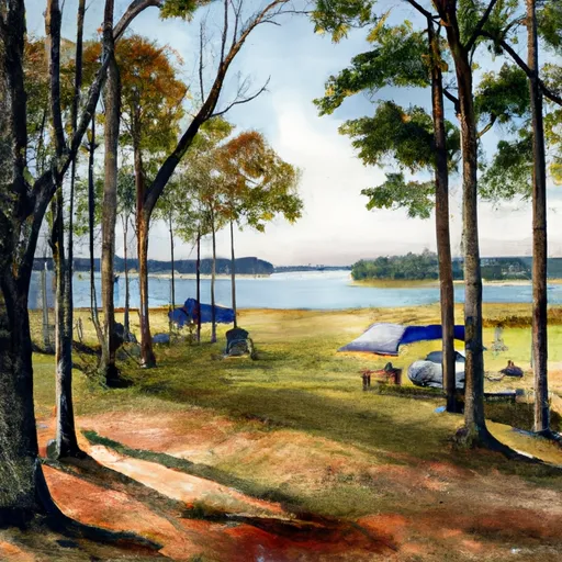
Lake Boque Homa
Reservations are accepted at Lake Boque Homa camping area, allowing campers to secure their preferred camping spot in advance. It is recommended to make a reservation, especially during peak seasons, to ensure availability.
The best time of year to visit Lake Boque Homa camping area is during the spring and fall seasons when the weather is mild and comfortable for outdoor activities. Summers can be hot and humid, while winters may bring occasional chilly temperatures. It is advisable to check the weather forecast before planning a visit.
While camping at Lake Boque Homa, visitors can explore the beautiful lake and its surroundings, engage in fishing or boating activities, and enjoy the scenic trails for hiking. However, it is important to be cautious of the local wildlife, such as snakes or insects, and adhere to any safety guidelines provided by the campground authorities.
What's on-site at Lake Boque Homa
Key facilities Snoflo tracks for this campground. Confirm with the operator before booking -- amenities can change seasonally.
Plan your trip down to the hour
Same weather feed Snoflo's iOS app uses -- updated continuously from NOAA / yr.no.
Next 5 days, hour by hour
Temperature line with weather symbols on top, snow + rain accumulation as columns, humidity as a dotted line.
5-day forecast table
Every 3 hours, broken out across temperature, snow, rain, humidity, and wind. Each cell is colour-coded relative to the column min/max so trends jump out at a glance.
| Time | Condition | Temp (°F) | Snow (in) | Rain (in) | Humidity (%) | Wind (mps) | Wind dir |
|---|---|---|---|---|---|---|---|
| Loading detailed forecast… | |||||||
15-day temperature & precipitation
Daily temperatures, snow, and rain projected over the next two weeks. Hover any point for the full breakdown.
Other campgrounds in the area
Snoflo-tracked campsites within driving distance of Lake Boque Homa, with reservations status.
| Campground | Reservations | Toilets | View |
|---|---|---|---|
| Go Fish R. V. Park | ✗ | ✗ | → |
| Big Creek Waterpark | ✗ | ✗ | → |
| Maynor Creek Waterpark | ✗ | ✗ | → |
| Lake Claude Bennett | ✗ | ✗ | → |
| Archusa Creek Waterpark | ✗ | ✗ | → |
Nearby streamflow
USGS streamgauges within reach of Lake Boque Homa -- pulled live from the National Water Information System.
| Streamgauge | Discharge | View |
|---|---|---|
| Tallahala Creek At Laurel | 17 cfs | → |
| Tallahala Creek At Waldrup | 117 cfs | → |
| Chickasawhay River Nr Waynesboro | 833 cfs | → |
| Bogue Homo Nr Richton | 556 cfs | → |
| Leaf River Nr Collins | 233 cfs | → |
| Tallahala Creek Nr Runnelstown | 93 cfs | → |
Plan a longer trip
The closest parks, lakes, boat launches, and paddle runs so a camping night can grow into a full weekend.
Parks
- Cotton Mill Park
- Thompson Creek Park
- Bell Sandifer Leisure Park
- Jaycei Park
- Kamper Park
- Clarkco State Park
Camping essentials & Leave No Trace
- Pack it in, pack it out
- Take all trash, food scraps, and gear back with you to keep campsites clean and protect wildlife.
- Respect wildlife
- Observe animals from a distance, store food securely, and never feed wildlife to maintain natural behavior and safety.
- Know before you go
- Check weather, fire restrictions, trail conditions, and permit requirements to ensure a safe and well-planned trip.
- Minimize campfire impact
- Use established fire rings, keep fires small, fully extinguish them, or opt for a camp stove when fires are restricted.
- Leave what you find
- Preserve natural and cultural features by avoiding removal of plants, rocks, artifacts, or other elements of the environment.
Set push alerts in the Snoflo app
Save Lake Boque Homa as a favorite, set a custom threshold (precipitation, snowpack, freezing temperatures), and the iOS app will push the moment conditions cross.
About Lake Boque Homa
Can I make reservations at Lake Boque Homa?
This campground does not appear to accept reservations -- it's typically first-come, first-served. Arrive early on summer weekends.
How fresh is the weather data on this page?
The hourly forecast updates throughout the day from the NOAA / yr.no public feeds. Streamflow data is pulled live from USGS streamgauges and snowpack from the NRCS SNOTEL network.
What's the best time of year to visit?
Use the 15-day temperature & precipitation outlook on this page to plan -- pick a window with comfortable temperatures and low precipitation. For longer trips, the 5-day hourly meteogram shows snow + rain accumulation hour-by-hour.
How do I get to Lake Boque Homa?
Tap Directions in the hero above to open driving directions in Google Maps, or Open in map to center the Snoflo interactive map on the campground.
Can I get alerts when conditions change?
Yes -- alerts are managed through the Snoflo iOS app. Favorite this campground, set a threshold (temperature, snowpack, precipitation), and you'll get a push the moment it crosses.
Other campgrounds near here
Snoflo-tracked campgrounds within driving distance of Lake Boque Homa.