Basin Campground campground
Community Reviews
Been here? Share the conditions.
Reviews, ratings & photos are added in the free Snoflo iOS app — rate a spot, tag the conditions, and your visit is verified by location. Add or manage your reviews from the app.
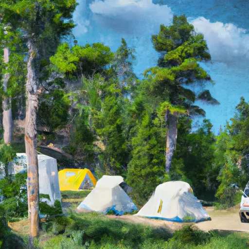
Basin Campground
Reservations are not accepted at Basin Campground, making it a first-come, first-served area. It is recommended to arrive early during peak seasons to secure a campsite. The best time of year to visit Basin Campground is during the summer months when the weather is mild and ideal for outdoor activities. However, it is important to note that the campground is only accessible by four-wheel-drive vehicles, as the road leading to it can be rough and challenging.
While camping at Basin Campground, visitors can explore the surrounding area and take advantage of nearby attractions. The campground is located near the Little Belt Mountains, offering hiking opportunities and scenic views. It is also close to the historic mining town of Basin, where visitors can explore its rich history. However, campers should be cautious of wildlife in the area, especially bears. Proper food storage and cautious behavior are necessary to ensure a safe camping experience.
In conclusion, Basin Campground in Montana provides a serene and well-equipped camping area, offering amenities such as picnic tables, fire rings, and vault toilets. Reservations are not accepted, so arriving early is recommended. The best time to visit is during the summer, taking into account the rugged road leading to the campground. Campers can enjoy nearby attractions like the Little Belt Mountains and the historic mining town of Basin, but should be cautious of wildlife, particularly bears.
What's on-site at Basin Campground
Key facilities Snoflo tracks for this campground. Confirm with the operator before booking -- amenities can change seasonally.
Plan your trip down to the hour
Same weather feed Snoflo's iOS app uses -- updated continuously from NOAA / yr.no.
Next 5 days, hour by hour
Temperature line with weather symbols on top, snow + rain accumulation as columns, humidity as a dotted line.
5-day forecast table
Every 3 hours, broken out across temperature, snow, rain, humidity, and wind. Each cell is colour-coded relative to the column min/max so trends jump out at a glance.
| Time | Condition | Temp (°F) | Snow (in) | Rain (in) | Humidity (%) | Wind (mps) | Wind dir |
|---|---|---|---|---|---|---|---|
| Loading detailed forecast… | |||||||
15-day temperature & precipitation
Daily temperatures, snow, and rain projected over the next two weeks. Hover any point for the full breakdown.
Other campgrounds in the area
Snoflo-tracked campsites within driving distance of Basin Campground, with reservations status.
| Campground | Reservations | Toilets | View |
|---|---|---|---|
| Perry's Rv Park | ✗ | ✗ | → |
| Sheridan Campground | ✗ | ✗ | → |
| Rattin Campground | ✗ | ✗ | → |
| Rattine Campground | ✗ | ✗ | → |
| Parkside Campground And Group Campsites | ✓ | ✗ | → |
Nearby streamflow
USGS streamgauges within reach of Basin Campground -- pulled live from the National Water Information System.
| Streamgauge | Discharge | View |
|---|---|---|
| Rock Creek Near Red Lodge Mt | 440 cfs | → |
| West Rosebud Creek Near Roscoe Mt | 430 cfs | → |
| Clarks Fork Yellowstone River Nr Belfry Mt | 1,800 cfs | → |
| Willow Creek Near Boyd Mt | 54 cfs | → |
| Red Lodge Cr Ab Cooney Re Nr Boyd Mt | 42 cfs | → |
| Stillwater River Near Absarokee Mt | 1,810 cfs | → |
Nearby snow depths
NRCS SNOTEL stations within reach of Basin Campground -- relevant when planning a shoulder-season or alpine trip.
| SNOTEL station | Snowpack | 24h Snowfall | View |
|---|---|---|---|
| Nohrsc Cole Creek | 0.0 in | 0.0 in | → |
| Cole Creek | 0.0 in | 0.0 in | → |
| Nohrsc Burnt Mtn | 0.0 in | 0.0 in | → |
| Burnt Mtn | 0.0 in | 0.0 in | → |
| Red Lodge | 0.0 in | 0.0 in | → |
| Beartooth Lake | 0.0 in | 0.0 in | → |
Plan a longer trip
The closest parks, lakes, boat launches, and paddle runs so a camping night can grow into a full weekend.
Parks
- Custer National Forest
- Wilderness Absaroka-Beartooth
- Cooney State Park
- Farm Service Agency Interest Of Montana National Wildlife Refuge
- North Absaroka Wilderness
Boat launches
- Beartooth High Lakes Trail Wyoming
- Beartooth Highway Wyoming
- Cooney Reservoir State Park - Red Lodge Creek
- Cooney Reservoir State Park - Lakeshore
- Cooney Reservoir State Park - Northshore
- Clarks Fork Boat Launch
Fishing spots
Points of interest
- Red Lodge Clay Center
- Beartooth Gallery Fine Art
- Depot Gallery
- Kinzley
- Carbon County Museum
- Yellowstone Wildlife Sanctuary
Paddle runs
- Custer Boundary, Sec. 6, T8s, R20e To Absaroka-Beartooth Wilderness Boundary
- Custer Forest Boundary, Sec. 19, T8s, R20e To Absaroka-Beartooth Wilderness Boundary
- Confluence Rock Creek, Sec. 34, T8s, R19e To Absaroka-Beartooth Wilderness Boundary
- Absaroka-Beartooth Wilderness Boundary To Headwaters, Sec. 10, T9s, R17e
- Absaroka-Beartooth Wilderness Boundary To Headwaters, Sec. 25, T8s, R17e
- Custer Forest Boundary, Sec. 1, T7s, S16e To Absaroka-Beartooth Wilderness Boundary
Camping essentials & Leave No Trace
- Pack it in, pack it out
- Take all trash, food scraps, and gear back with you to keep campsites clean and protect wildlife.
- Respect wildlife
- Observe animals from a distance, store food securely, and never feed wildlife to maintain natural behavior and safety.
- Know before you go
- Check weather, fire restrictions, trail conditions, and permit requirements to ensure a safe and well-planned trip.
- Minimize campfire impact
- Use established fire rings, keep fires small, fully extinguish them, or opt for a camp stove when fires are restricted.
- Leave what you find
- Preserve natural and cultural features by avoiding removal of plants, rocks, artifacts, or other elements of the environment.
Set push alerts in the Snoflo app
Save Basin Campground as a favorite, set a custom threshold (precipitation, snowpack, freezing temperatures), and the iOS app will push the moment conditions cross.
About Basin Campground
Can I make reservations at Basin Campground?
This campground does not appear to accept reservations -- it's typically first-come, first-served. Arrive early on summer weekends.
How fresh is the weather data on this page?
The hourly forecast updates throughout the day from the NOAA / yr.no public feeds. Streamflow data is pulled live from USGS streamgauges and snowpack from the NRCS SNOTEL network.
What's the best time of year to visit?
Use the 15-day temperature & precipitation outlook on this page to plan -- pick a window with comfortable temperatures and low precipitation. For longer trips, the 5-day hourly meteogram shows snow + rain accumulation hour-by-hour.
How do I get to Basin Campground?
Tap Directions in the hero above to open driving directions in Google Maps, or Open in map to center the Snoflo interactive map on the campground.
Can I get alerts when conditions change?
Yes -- alerts are managed through the Snoflo iOS app. Favorite this campground, set a threshold (temperature, snowpack, precipitation), and you'll get a push the moment it crosses.
Other campgrounds near here
Snoflo-tracked campgrounds within driving distance of Basin Campground.