Holter Dam Campground
Community Reviews
Been here? Share the conditions.
Reviews, ratings & photos are added in the free Snoflo iOS app — rate a spot, tag the conditions, and your visit is verified by location. Add or manage your reviews from the app.
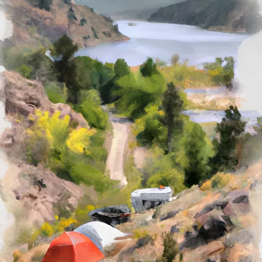
Holter Dam
Reservations are not accepted at the Holter Dam camping area, and campsites are available on a first-come, first-served basis. Therefore, it is advisable to arrive early during peak season to secure a spot. The best time to visit this camping area is during the summer months, from June to August, when the weather is favorable, and the river offers great fishing and boating experiences.
While camping at Holter Dam, visitors can explore the surrounding area and enjoy activities such as hiking, bird-watching, and wildlife spotting. It is essential to be cautious of wildlife encounters, including bears, and store food properly to prevent attracting wildlife. Additionally, campers should be aware of potential river currents and take necessary precautions while swimming or boating in the Missouri River. Overall, the Holter Dam camping area is a picturesque location that offers a range of amenities and recreational opportunities for campers seeking a peaceful and scenic experience in Montana.
What's on-site at Holter Dam
Key facilities Snoflo tracks for this campground. Confirm with the operator before booking -- amenities can change seasonally.
Plan your trip down to the hour
Same weather feed Snoflo's iOS app uses -- updated continuously from NOAA / yr.no.
Next 5 days, hour by hour
Temperature line with weather symbols on top, snow + rain accumulation as columns, humidity as a dotted line.
5-day forecast table
Every 3 hours, broken out across temperature, snow, rain, humidity, and wind. Each cell is colour-coded relative to the column min/max so trends jump out at a glance.
| Time | Condition | Temp (°F) | Snow (in) | Rain (in) | Humidity (%) | Wind (mps) | Wind dir |
|---|---|---|---|---|---|---|---|
| Loading detailed forecast… | |||||||
15-day temperature & precipitation
Daily temperatures, snow, and rain projected over the next two weeks. Hover any point for the full breakdown.
Other campgrounds in the area
Snoflo-tracked campsites within driving distance of Holter Dam, with reservations status.
| Campground | Reservations | Toilets | View |
|---|---|---|---|
| Holter Lake Campground | ✗ | ✗ | → |
| Holter Lake State Rec Area | ✗ | ✗ | → |
| Wolf Creek Bridge Fas | ✗ | ✓ | → |
| Log Gulch | ✗ | ✗ | → |
| Departure Point | ✗ | ✓ | → |
Nearby streamflow
USGS streamgauges within reach of Holter Dam -- pulled live from the National Water Information System.
| Streamgauge | Discharge | View |
|---|---|---|
| Missouri River Bl Holter Dam Nr Wolf Cr Mt | 3,390 cfs | → |
| Little Prickly Pear Cr At Wolf Cr Mt | 51 cfs | → |
| Dearborn River Near Craig Mt | 116 cfs | → |
| Missouri River Bl Hauser Lake Nr Helena Mt | 3,320 cfs | → |
| Missouri River At Cascade Mt | 3,770 cfs | → |
| Tenmile Creek Near Helena Mt | 6 cfs | → |
Nearby snow depths
NRCS SNOTEL stations within reach of Holter Dam -- relevant when planning a shoulder-season or alpine trip.
| SNOTEL station | Snowpack | 24h Snowfall | View |
|---|---|---|---|
| Nohrsc Helena 5.8 Ne | 0.0 in | 0.0 in | → |
| Nevada Ridge | 0.0 in | 0.0 in | → |
| Nohrsc Nevada Ridge | 0.0 in | 0.0 in | → |
| Nohrsc Helena 2.0 Nnw | 0.0 in | 0.0 in | → |
| Helena Ap Asos | 0.0 in | 0.0 in | → |
| Nohrsc Copper Bottom | 0.0 in | 0.0 in | → |
Plan a longer trip
The closest parks, lakes, boat launches, and paddle runs so a camping night can grow into a full weekend.
Parks
- Holter Lake Recreation Area
- Wilderness Gates Of The Mountains
- Tower Rock State Park
- Black Sandy State Park
- Lewis And Clark National Forest
- Spring Meadow Lake State Park
Boat launches
- Holter Dam Boat Ramp
- Beartooth Road Lewis And Clark County
- Holter Lake Boat Ramp
- Wolf Creek Bridge
- Log Gulch Boat Ramp
- Craig
Fishing spots
- Dearborn River
- Little Prickly Pear Creek
- Missouri River Fishing Access Site
- Prickly Pear Creek
- Silver Creek
- Alice Creek
Camping essentials & Leave No Trace
- Pack it in, pack it out
- Take all trash, food scraps, and gear back with you to keep campsites clean and protect wildlife.
- Respect wildlife
- Observe animals from a distance, store food securely, and never feed wildlife to maintain natural behavior and safety.
- Know before you go
- Check weather, fire restrictions, trail conditions, and permit requirements to ensure a safe and well-planned trip.
- Minimize campfire impact
- Use established fire rings, keep fires small, fully extinguish them, or opt for a camp stove when fires are restricted.
- Leave what you find
- Preserve natural and cultural features by avoiding removal of plants, rocks, artifacts, or other elements of the environment.
Set push alerts in the Snoflo app
Save Holter Dam as a favorite, set a custom threshold (precipitation, snowpack, freezing temperatures), and the iOS app will push the moment conditions cross.
About Holter Dam
Can I make reservations at Holter Dam?
This campground does not appear to accept reservations -- it's typically first-come, first-served. Arrive early on summer weekends.
How fresh is the weather data on this page?
The hourly forecast updates throughout the day from the NOAA / yr.no public feeds. Streamflow data is pulled live from USGS streamgauges and snowpack from the NRCS SNOTEL network.
What's the best time of year to visit?
Use the 15-day temperature & precipitation outlook on this page to plan -- pick a window with comfortable temperatures and low precipitation. For longer trips, the 5-day hourly meteogram shows snow + rain accumulation hour-by-hour.
How do I get to Holter Dam?
Tap Directions in the hero above to open driving directions in Google Maps, or Open in map to center the Snoflo interactive map on the campground.
Can I get alerts when conditions change?
Yes -- alerts are managed through the Snoflo iOS app. Favorite this campground, set a threshold (temperature, snowpack, precipitation), and you'll get a push the moment it crosses.
Other campgrounds near here
Snoflo-tracked campgrounds within driving distance of Holter Dam.