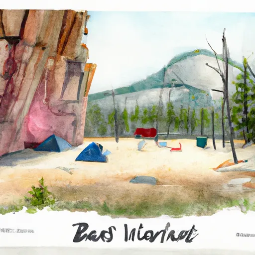
The Wall Campground
Community Reviews
Been here? Share the conditions.
Reviews, ratings & photos are added in the free Snoflo iOS app — rate a spot, tag the conditions, and your visit is verified by location. Add or manage your reviews from the app.
The Wall
The Wall Campsite is a great place to escape from the hustle and bustle of everyday life. The campground offers basic amenities, such as picnic tables and fire pits, but visitors must bring their own water and pack out all trash. The area is also home to a variety of wildlife, including bears, so visitors are advised to take appropriate precautions.
The best time to visit The Wall Campsite is in the summer months, between June and September. During this time, temperatures average between 50-70 degrees Fahrenheit during the day and drop down to the 30s at night. The area is popular for hiking, fishing, and mountain biking.
Interesting fact: The Wall Campsite is located in a designated Wilderness Study Area, which means it has been identified by the Bureau of Land Management as having wilderness characteristics and is being considered for permanent wilderness designation.
Overall, The Wall Campsite is a beautiful and peaceful spot to camp in Montana's great outdoors.
What's on-site at The Wall
Key facilities Snoflo tracks for this campground. Confirm with the operator before booking -- amenities can change seasonally.
Plan your trip down to the hour
Same weather feed Snoflo's iOS app uses -- updated continuously from NOAA / yr.no.
Next 5 days, hour by hour
Temperature line with weather symbols on top, snow + rain accumulation as columns, humidity as a dotted line.
5-day forecast table
Every 3 hours, broken out across temperature, snow, rain, humidity, and wind. Each cell is colour-coded relative to the column min/max so trends jump out at a glance.
| Time | Condition | Temp (°F) | Snow (in) | Rain (in) | Humidity (%) | Wind (mps) | Wind dir |
|---|---|---|---|---|---|---|---|
| Loading detailed forecast… | |||||||
15-day temperature & precipitation
Daily temperatures, snow, and rain projected over the next two weeks. Hover any point for the full breakdown.
Other campgrounds in the area
Snoflo-tracked campsites within driving distance of The Wall, with reservations status.
| Campground | Reservations | Toilets | View |
|---|---|---|---|
| Slaughter River | ✗ | ✗ | → |
| Judith Landing | ✗ | ✓ | → |
| Pablo Rapids (Lower Site) | ✗ | ✗ | → |
| Dark Butte | ✗ | ✗ | → |
| Hole In The Wall Rec Site | ✗ | ✗ | → |
Nearby streamflow
USGS streamgauges within reach of The Wall -- pulled live from the National Water Information System.
| Streamgauge | Discharge | View |
|---|---|---|
| Judith River Nr Mouth | 215 cfs | → |
| Missouri River At Virgelle Mt | 5,960 cfs | → |
| Teton River At Loma Mt | 6 cfs | → |
| Marias River Near Loma Mt | 1,400 cfs | → |
| Missouri River At Fort Benton Mt | 4,720 cfs | → |
| Missouri River Near Landusky Mt | 6,300 cfs | → |
Nearby snow depths
NRCS SNOTEL stations within reach of The Wall -- relevant when planning a shoulder-season or alpine trip.
| SNOTEL station | Snowpack | 24h Snowfall | View |
|---|---|---|---|
| Christina W | 0.0 in | 0.0 in | → |
| Winifred Ne | 0.0 in | 0.0 in | → |
| Big Sandy Se | 0.0 in | 0.0 in | → |
| Mt Mesonet Coffee Creek N | 0.0 in | 0.0 in | → |
| Nohrsc Rocky Boy | 0.0 in | 0.0 in | → |
| Rocky Boy | 0.0 in | 0.0 in | → |
Plan a longer trip
The closest parks, lakes, boat launches, and paddle runs so a camping night can grow into a full weekend.
Boat launches
- The Wall
- Slaughter River
- Judith Landing
- Mt-236 Chouteau County
- Pablo Rapids (Lower Site)
- Hole In The Wall Rec Site
Fishing spots
- Panton Coulee Reservoir
- Warm Spring Creek
- Big Lake
- Als Coulee Reservoir
- Sage Creek (Judith Drainage)
- Upper Carters Pond
Camping essentials & Leave No Trace
- Pack it in, pack it out
- Take all trash, food scraps, and gear back with you to keep campsites clean and protect wildlife.
- Respect wildlife
- Observe animals from a distance, store food securely, and never feed wildlife to maintain natural behavior and safety.
- Know before you go
- Check weather, fire restrictions, trail conditions, and permit requirements to ensure a safe and well-planned trip.
- Minimize campfire impact
- Use established fire rings, keep fires small, fully extinguish them, or opt for a camp stove when fires are restricted.
- Leave what you find
- Preserve natural and cultural features by avoiding removal of plants, rocks, artifacts, or other elements of the environment.
Set push alerts in the Snoflo app
Save The Wall as a favorite, set a custom threshold (precipitation, snowpack, freezing temperatures), and the iOS app will push the moment conditions cross.
About The Wall
Can I make reservations at The Wall?
This campground does not appear to accept reservations -- it's typically first-come, first-served. Arrive early on summer weekends.
How fresh is the weather data on this page?
The hourly forecast updates throughout the day from the NOAA / yr.no public feeds. Streamflow data is pulled live from USGS streamgauges and snowpack from the NRCS SNOTEL network.
What's the best time of year to visit?
Use the 15-day temperature & precipitation outlook on this page to plan -- pick a window with comfortable temperatures and low precipitation. For longer trips, the 5-day hourly meteogram shows snow + rain accumulation hour-by-hour.
How do I get to The Wall?
Tap Directions in the hero above to open driving directions in Google Maps, or Open in map to center the Snoflo interactive map on the campground.
Can I get alerts when conditions change?
Yes -- alerts are managed through the Snoflo iOS app. Favorite this campground, set a threshold (temperature, snowpack, precipitation), and you'll get a push the moment it crosses.
Other campgrounds near here
Snoflo-tracked campgrounds within driving distance of The Wall.