Yorks Islands Fas Campground
Community Reviews
Been here? Share the conditions.
Reviews, ratings & photos are added in the free Snoflo iOS app — rate a spot, tag the conditions, and your visit is verified by location. Add or manage your reviews from the app.
Yorks Islands Fas
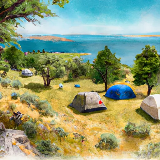
The campground boasts several amenities, including picnic tables, fire rings, toilets, and potable water. The campground is available on a first-come, first-served basis, and it has 10 campsites available for visitors. An interesting fact about the area is that it is known for its world-class fishing opportunities.
The best time to visit Yorks Islands FAS Camping Area is during the summer months, from June to August when the temperatures are mild, and the weather is pleasant. The average temperature during this time is around 70°F during the day and 50°F at night.
Overall, the Yorks Islands FAS Camping Area is a perfect destination for those who want to escape the hustle and bustle of city life and enjoy the serene beauty of nature. The area provides an excellent opportunity for camping, fishing, hiking, and exploring the surrounding natural wonders.
What's on-site at Yorks Islands Fas
Key facilities Snoflo tracks for this campground. Confirm with the operator before booking -- amenities can change seasonally.
Plan your trip down to the hour
Same weather feed Snoflo's iOS app uses -- updated continuously from NOAA / yr.no.
Next 5 days, hour by hour
Temperature line with weather symbols on top, snow + rain accumulation as columns, humidity as a dotted line.
5-day forecast table
Every 3 hours, broken out across temperature, snow, rain, humidity, and wind. Each cell is colour-coded relative to the column min/max so trends jump out at a glance.
| Time | Condition | Temp (°F) | Snow (in) | Rain (in) | Humidity (%) | Wind (mps) | Wind dir |
|---|---|---|---|---|---|---|---|
| Loading detailed forecast… | |||||||
15-day temperature & precipitation
Daily temperatures, snow, and rain projected over the next two weeks. Hover any point for the full breakdown.
Other campgrounds in the area
Snoflo-tracked campsites within driving distance of Yorks Islands Fas, with reservations status.
| Campground | Reservations | Toilets | View |
|---|---|---|---|
| Deepdale Fas | ✗ | ✗ | → |
| Saltzman's Rv Park | ✗ | ✗ | → |
| Canyon Ferry Lake | ✗ | ✓ | → |
| Toston Dam | ✗ | ✓ | → |
| Lower Toston | ✗ | ✗ | → |
Nearby streamflow
USGS streamgauges within reach of Yorks Islands Fas -- pulled live from the National Water Information System.
| Streamgauge | Discharge | View |
|---|---|---|
| Missouri River At Toston Mt | 3,350 cfs | → |
| Jefferson River Near Three Forks Mt | 711 cfs | → |
| Gallatin River At Logan Mt | 492 cfs | → |
| Prickly Pear Creek Near Clancy Mt | 17 cfs | → |
| Boulder River Near Boulder Mt | 58 cfs | → |
| Tenmile Creek Near Helena Mt | 4 cfs | → |
Nearby snow depths
NRCS SNOTEL stations within reach of Yorks Islands Fas -- relevant when planning a shoulder-season or alpine trip.
| SNOTEL station | Snowpack | 24h Snowfall | View |
|---|---|---|---|
| Tizer Basin | 0.0 in | 0.0 in | → |
| Nohrsc Tizer Basin | 0.0 in | 0.0 in | → |
| Nohrsc Boulder Mountain | 0.0 in | 0.0 in | → |
| Boulder Mountain | 0.0 in | 0.0 in | → |
| Pickfoot Creek | 1.0 in | 0.0 in | → |
| Pickfoot Creek | 1.0 in | 0.0 in | → |
Plan a longer trip
The closest parks, lakes, boat launches, and paddle runs so a camping night can grow into a full weekend.
Parks
- Helena National Forest
- Elkhorn State Park
- Missouri Headwaters State Park
- Madison Buffalo Jump State Park
- Cruse Park
- Mount Helena City Park
Boat launches
Fishing spots
- Crow Creek
- Canyon Ferry Lake
- Deep Creek (Upper Missouri Drainage)
- Duck Creek (Upper Missouri Drainage)
- Leslie Lake
- Glenwood Lake
Camping essentials & Leave No Trace
- Pack it in, pack it out
- Take all trash, food scraps, and gear back with you to keep campsites clean and protect wildlife.
- Respect wildlife
- Observe animals from a distance, store food securely, and never feed wildlife to maintain natural behavior and safety.
- Know before you go
- Check weather, fire restrictions, trail conditions, and permit requirements to ensure a safe and well-planned trip.
- Minimize campfire impact
- Use established fire rings, keep fires small, fully extinguish them, or opt for a camp stove when fires are restricted.
- Leave what you find
- Preserve natural and cultural features by avoiding removal of plants, rocks, artifacts, or other elements of the environment.
Set push alerts in the Snoflo app
Save Yorks Islands Fas as a favorite, set a custom threshold (precipitation, snowpack, freezing temperatures), and the iOS app will push the moment conditions cross.
About Yorks Islands Fas
Can I make reservations at Yorks Islands Fas?
This campground does not appear to accept reservations -- it's typically first-come, first-served. Arrive early on summer weekends.
How fresh is the weather data on this page?
The hourly forecast updates throughout the day from the NOAA / yr.no public feeds. Streamflow data is pulled live from USGS streamgauges and snowpack from the NRCS SNOTEL network.
What's the best time of year to visit?
Use the 15-day temperature & precipitation outlook on this page to plan -- pick a window with comfortable temperatures and low precipitation. For longer trips, the 5-day hourly meteogram shows snow + rain accumulation hour-by-hour.
How do I get to Yorks Islands Fas?
Tap Directions in the hero above to open driving directions in Google Maps, or Open in map to center the Snoflo interactive map on the campground.
Can I get alerts when conditions change?
Yes -- alerts are managed through the Snoflo iOS app. Favorite this campground, set a threshold (temperature, snowpack, precipitation), and you'll get a push the moment it crosses.
Other campgrounds near here
Snoflo-tracked campgrounds within driving distance of Yorks Islands Fas.