Nehalem Falls - State Forestry Campground
Community Reviews
Been here? Share the conditions.
Reviews, ratings & photos are added in the free Snoflo iOS app — rate a spot, tag the conditions, and your visit is verified by location. Add or manage your reviews from the app.
Nehalem Falls - State Forestry
Reservations at Nehalem Falls - State Forestry camping area are not accepted, and campsites are available on a first-come, first-served basis. It is recommended to arrive early, especially during popular seasons, to secure a spot.
The best time to visit Nehalem Falls - State Forestry camping area is during the summer months when the weather is mild and ideal for outdoor activities. However, it is worth noting that this campground can get quite busy during peak season, so be prepared for potential crowds.
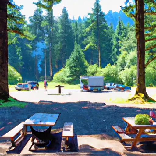
Nehalem Falls - State Forestry camping area offers a tranquil setting alongside the Nehalem River, providing campers with an opportunity for fishing and swimming. However, it is important to be cautious of the strong currents in the river and always exercise safety precautions. Additionally, campers should be aware of the wildlife in the area and take necessary precautions to store food properly and avoid any potential encounters with animals.
Overall, Nehalem Falls - State Forestry camping area is a picturesque destination with a range of amenities, making it a great choice for outdoor enthusiasts looking to immerse themselves in Oregon's natural beauty.
What's on-site at Nehalem Falls - State Forestry
Key facilities Snoflo tracks for this campground. Confirm with the operator before booking -- amenities can change seasonally.
Plan your trip down to the hour
Same weather feed Snoflo's iOS app uses -- updated continuously from NOAA / yr.no.
Next 5 days, hour by hour
Temperature line with weather symbols on top, snow + rain accumulation as columns, humidity as a dotted line.
5-day forecast table
Every 3 hours, broken out across temperature, snow, rain, humidity, and wind. Each cell is colour-coded relative to the column min/max so trends jump out at a glance.
| Time | Condition | Temp (°F) | Snow (in) | Rain (in) | Humidity (%) | Wind (mps) | Wind dir |
|---|---|---|---|---|---|---|---|
| Loading detailed forecast… | |||||||
15-day temperature & precipitation
Daily temperatures, snow, and rain projected over the next two weeks. Hover any point for the full breakdown.
Other campgrounds in the area
Snoflo-tracked campsites within driving distance of Nehalem Falls - State Forestry, with reservations status.
| Campground | Reservations | Toilets | View |
|---|---|---|---|
| Nehalem Falls Campground | ✗ | ✗ | → |
| Spruce Run County Park | ✗ | ✗ | → |
| Rockaway Beach Rv Park | ✗ | ✗ | → |
| Kilchis Park | ✗ | ✗ | → |
| Hiker/Biker | ✗ | ✗ | → |
Nearby streamflow
USGS streamgauges within reach of Nehalem Falls - State Forestry -- pulled live from the National Water Information System.
| Streamgauge | Discharge | View |
|---|---|---|
| Nehalem River Near Foss | 203 cfs | → |
| Wilson River Near Tillamook | 112 cfs | → |
| Trask River Above Cedar Creek | 115 cfs | → |
| Nehalem River Near Vernonia | 12 cfs | → |
| Tucca Creek Near Blaine | 1 cfs | → |
| Nestucca River Near Beaver | 103 cfs | → |
Nearby snow depths
NRCS SNOTEL stations within reach of Nehalem Falls - State Forestry -- relevant when planning a shoulder-season or alpine trip.
| SNOTEL station | Snowpack | 24h Snowfall | View |
|---|---|---|---|
| Saddle Mountain | 1.0 in | 1.0 in | → |
| Seine Creek | 0.0 in | 0.0 in | → |
| Astoria Airport | 0.0 in | 0.0 in | → |
| Miller Woods | 0.0 in | 0.0 in | → |
| Hillsboro Airport Asos & Lawrs | 0.0 in | 0.0 in | → |
| Nohrsc Miller Woods | 0.0 in | 0.0 in | → |
Plan a longer trip
The closest parks, lakes, boat launches, and paddle runs so a camping night can grow into a full weekend.
Parks
- Oswald West State Park
- Neahkahnie-Manzanita State Recreation Site
- Nehalem Bay State Park
- Manhattan Beach State Recreation Site
- Hug Point State Recreation Site
- Rockaway Beach State Recreation Site
Boat launches
- Beaver Slide
- Mohler Sand &Amp; Gravel
- Roy Creek Park
- Aldervale
- Tohl Ranch Road Tillamook County
- Tideland Road 13500, Nehalem
Camping essentials & Leave No Trace
- Pack it in, pack it out
- Take all trash, food scraps, and gear back with you to keep campsites clean and protect wildlife.
- Respect wildlife
- Observe animals from a distance, store food securely, and never feed wildlife to maintain natural behavior and safety.
- Know before you go
- Check weather, fire restrictions, trail conditions, and permit requirements to ensure a safe and well-planned trip.
- Minimize campfire impact
- Use established fire rings, keep fires small, fully extinguish them, or opt for a camp stove when fires are restricted.
- Leave what you find
- Preserve natural and cultural features by avoiding removal of plants, rocks, artifacts, or other elements of the environment.
Set push alerts in the Snoflo app
Save Nehalem Falls - State Forestry as a favorite, set a custom threshold (precipitation, snowpack, freezing temperatures), and the iOS app will push the moment conditions cross.
About Nehalem Falls - State Forestry
Can I make reservations at Nehalem Falls - State Forestry?
This campground does not appear to accept reservations -- it's typically first-come, first-served. Arrive early on summer weekends.
How fresh is the weather data on this page?
The hourly forecast updates throughout the day from the NOAA / yr.no public feeds. Streamflow data is pulled live from USGS streamgauges and snowpack from the NRCS SNOTEL network.
What's the best time of year to visit?
Use the 15-day temperature & precipitation outlook on this page to plan -- pick a window with comfortable temperatures and low precipitation. For longer trips, the 5-day hourly meteogram shows snow + rain accumulation hour-by-hour.
How do I get to Nehalem Falls - State Forestry?
Tap Directions in the hero above to open driving directions in Google Maps, or Open in map to center the Snoflo interactive map on the campground.
Can I get alerts when conditions change?
Yes -- alerts are managed through the Snoflo iOS app. Favorite this campground, set a threshold (temperature, snowpack, precipitation), and you'll get a push the moment it crosses.
Other campgrounds near here
Snoflo-tracked campgrounds within driving distance of Nehalem Falls - State Forestry.