Switchback Hill Trailhead Campground
Community Reviews
Been here? Share the conditions.
Reviews, ratings & photos are added in the free Snoflo iOS app — rate a spot, tag the conditions, and your visit is verified by location. Add or manage your reviews from the app.
Switchback Hill Trailhead
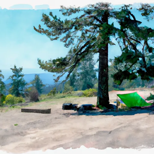
The campground amenities include outhouses, picnic tables, and fire rings. The campground is first-come-first-serve, with 12 campsites available. An interesting fact about the area is that it was once a popular location for gold mining in the late 1800s.
The best time of year to visit Switchback Hill Trailhead Camping Area is from June to September, with average temperatures ranging from 65 to 85 degrees Fahrenheit. It is important to note that the area may be inaccessible during the winter months due to snow.
Nearby points of interest include the historic town of John Day, where visitors can learn about the area's rich mining history at the Kam Wah Chung State Heritage Site. The nearby Strawberry Mountains also offer hiking and scenic drives.
Overall, Switchback Hill Trailhead Camping Area is a serene and picturesque camping destination, perfect for those looking to escape the hustle and bustle of city life and immerse themselves in nature.
What's on-site at Switchback Hill Trailhead
Key facilities Snoflo tracks for this campground. Confirm with the operator before booking -- amenities can change seasonally.
Plan your trip down to the hour
Same weather feed Snoflo's iOS app uses -- updated continuously from NOAA / yr.no.
Next 5 days, hour by hour
Temperature line with weather symbols on top, snow + rain accumulation as columns, humidity as a dotted line.
5-day forecast table
Every 3 hours, broken out across temperature, snow, rain, humidity, and wind. Each cell is colour-coded relative to the column min/max so trends jump out at a glance.
| Time | Condition | Temp (°F) | Snow (in) | Rain (in) | Humidity (%) | Wind (mps) | Wind dir |
|---|---|---|---|---|---|---|---|
| Loading detailed forecast… | |||||||
15-day temperature & precipitation
Daily temperatures, snow, and rain projected over the next two weeks. Hover any point for the full breakdown.
Other campgrounds in the area
Snoflo-tracked campsites within driving distance of Switchback Hill Trailhead, with reservations status.
| Campground | Reservations | Toilets | View |
|---|---|---|---|
| Copperfield Park | ✗ | ✗ | → |
| Lake Fork Campground | ✗ | ✗ | → |
| Hells Canyon Park - Hells Canyon National Rec Area | ✗ | ✓ | → |
| Mccormick Park - Hells Canyon National Rec Area | ✗ | ✓ | → |
| Mccormick Park | ✗ | ✓ | → |
| Mccormick Campgrounds | ✗ | ✗ | → |
Nearby streamflow
USGS streamgauges within reach of Switchback Hill Trailhead -- pulled live from the National Water Information System.
| Streamgauge | Discharge | View |
|---|---|---|
| Snake River At Hells Canyon Dam Id-Or State Line | 19,200 cfs | → |
| Weiser River Nr Cambridge Id | 81 cfs | → |
| Nf Payette River At Mccall Id | 57 cfs | → |
| Little Salmon River At Riggins Id | 220 cfs | → |
| Imnaha River At Imnaha | 150 cfs | → |
| Lake Fork Payette River Ab Jumbo Cr Nr Mccall Id | 35 cfs | → |
Nearby snow depths
NRCS SNOTEL stations within reach of Switchback Hill Trailhead -- relevant when planning a shoulder-season or alpine trip.
| SNOTEL station | Snowpack | 24h Snowfall | View |
|---|---|---|---|
| Swan Lake Mtn | 0.0 in | 0.0 in | → |
| Nohrsc Swan Lake Mtn | 4.0 in | 0.0 in | → |
| Klamath Falls | 0.0 in | 0.0 in | → |
| Nohrsc Altamont 0.4 Wnw | 0.0 in | 0.0 in | → |
| Nohrsc Taylor Butte | 0.0 in | 0.0 in | → |
| Taylor Butte | 0.0 in | 0.0 in | → |
Plan a longer trip
The closest parks, lakes, boat launches, and paddle runs so a camping night can grow into a full weekend.
Parks
- Painted Rocks State Park
- National Wild And Scenic River Middle Fork Clearwater, Idaho
- Wilderness Selway-Bitterroot
- Big Hole National Battlefield
- Salmon National Wild And Scenic River
- Wilderness Anaconda Pintler
Boat launches
- Oxbow Boat Launch
- Copperfield Boat Launch
- Bob Creek
- Hells Canyon Road Adams County
- Carter's Landing
- Carters Old Boat Launch
Fishing spots
Camping essentials & Leave No Trace
- Pack it in, pack it out
- Take all trash, food scraps, and gear back with you to keep campsites clean and protect wildlife.
- Respect wildlife
- Observe animals from a distance, store food securely, and never feed wildlife to maintain natural behavior and safety.
- Know before you go
- Check weather, fire restrictions, trail conditions, and permit requirements to ensure a safe and well-planned trip.
- Minimize campfire impact
- Use established fire rings, keep fires small, fully extinguish them, or opt for a camp stove when fires are restricted.
- Leave what you find
- Preserve natural and cultural features by avoiding removal of plants, rocks, artifacts, or other elements of the environment.
Set push alerts in the Snoflo app
Save Switchback Hill Trailhead as a favorite, set a custom threshold (precipitation, snowpack, freezing temperatures), and the iOS app will push the moment conditions cross.
About Switchback Hill Trailhead
Can I make reservations at Switchback Hill Trailhead?
This campground does not appear to accept reservations -- it's typically first-come, first-served. Arrive early on summer weekends.
How fresh is the weather data on this page?
The hourly forecast updates throughout the day from the NOAA / yr.no public feeds. Streamflow data is pulled live from USGS streamgauges and snowpack from the NRCS SNOTEL network.
What's the best time of year to visit?
Use the 15-day temperature & precipitation outlook on this page to plan -- pick a window with comfortable temperatures and low precipitation. For longer trips, the 5-day hourly meteogram shows snow + rain accumulation hour-by-hour.
How do I get to Switchback Hill Trailhead?
Tap Directions in the hero above to open driving directions in Google Maps, or Open in map to center the Snoflo interactive map on the campground.
Can I get alerts when conditions change?
Yes -- alerts are managed through the Snoflo iOS app. Favorite this campground, set a threshold (temperature, snowpack, precipitation), and you'll get a push the moment it crosses.
Other campgrounds near here
Snoflo-tracked campgrounds within driving distance of Switchback Hill Trailhead.