Black Rock Mountain State Park campground
Community Reviews
Been here? Share the conditions.
Reviews, ratings & photos are added in the free Snoflo iOS app — rate a spot, tag the conditions, and your visit is verified by location. Add or manage your reviews from the app.
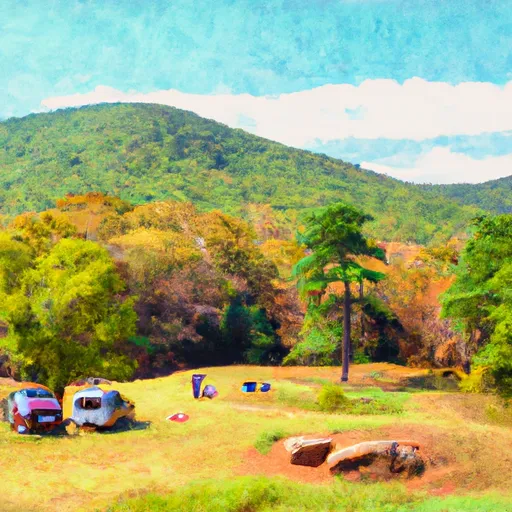
Black Rock Mountain State Park
The best time to visit Black Rock Mountain State Park is during the spring and fall seasons when the weather is mild, and the park's beauty is at its peak. The campground offers both RV and tent sites, providing options for different types of campers. Amenities include clean and well-maintained restrooms, hot showers, and picnic areas. Additionally, campers can enjoy hiking trails that offer breathtaking views of the surrounding mountains.
While visiting the camping area, campers should be cautious of potential wildlife encounters, particularly with black bears. It is advised to store all food securely and avoid leaving any food or trash outside. Additionally, campers should be mindful of the rugged terrain and steep slopes when exploring the park. Overall, Black Rock Mountain State Park offers a picturesque and well-equipped camping experience, making it an excellent choice for nature lovers looking to enjoy the beauty of Georgia's mountains.
What's on-site at Black Rock Mountain State Park
Key facilities Snoflo tracks for this campground. Confirm with the operator before booking -- amenities can change seasonally.
Plan your trip down to the hour
Same weather feed Snoflo's iOS app uses -- updated continuously from NOAA / yr.no.
Next 5 days, hour by hour
Temperature line with weather symbols on top, snow + rain accumulation as columns, humidity as a dotted line.
5-day forecast table
Every 3 hours, broken out across temperature, snow, rain, humidity, and wind. Each cell is colour-coded relative to the column min/max so trends jump out at a glance.
| Time | Condition | Temp (°F) | Snow (in) | Rain (in) | Humidity (%) | Wind (mps) | Wind dir |
|---|---|---|---|---|---|---|---|
| Loading detailed forecast… | |||||||
15-day temperature & precipitation
Daily temperatures, snow, and rain projected over the next two weeks. Hover any point for the full breakdown.
Other campgrounds in the area
Snoflo-tracked campsites within driving distance of Black Rock Mountain State Park, with reservations status.
| Campground | Reservations | Toilets | View |
|---|---|---|---|
| Nichols Campground | ✗ | ✗ | → |
| Sarahs Creek | ✗ | ✗ | → |
| Sarah's Creek Campground | ✓ | ✗ | → |
| Tallulah River Campground | ✓ | ✗ | → |
| Tallulah River | ✗ | ✗ | → |
Nearby streamflow
USGS streamgauges within reach of Black Rock Mountain State Park -- pulled live from the National Water Information System.
| Streamgauge | Discharge | View |
|---|---|---|
| Tallulah River Near Clayton | 65 cfs | → |
| Chattooga River Near Clayton | 207 cfs | → |
| Tallulah River Ab Powerhouse | 37 cfs | → |
| Little Tennessee River Near Prentiss | 132 cfs | → |
| Cartoogechaye Creek Near Franklin | 261 cfs | → |
| Little Tennessee R At Franklin | 1,050 cfs | → |
Nearby snow depths
NRCS SNOTEL stations within reach of Black Rock Mountain State Park -- relevant when planning a shoulder-season or alpine trip.
| SNOTEL station | Snowpack | 24h Snowfall | View |
|---|---|---|---|
| Germany Valley | 0.0 in | 0.0 in | → |
| Dillard 0.7 Nnw | 0.0 in | 0.0 in | → |
| Sautee 3.5 Sw | 0.0 in | 0.0 in | → |
| Bryson City 4 | 0.0 in | 0.0 in | → |
| Dahlonega | 0.0 in | 0.0 in | → |
| Brevard | 0.0 in | 0.0 in | → |
Plan a longer trip
The closest parks, lakes, boat launches, and paddle runs so a camping night can grow into a full weekend.
Parks
- Black Rock Mountain State Park
- Moccasin Creek State Park
- Wilderness Southern Nantahala
- National Wild And Scenic River Chattooga, North Carolina, South Carolina And Georgia
- Tallulah Gorge State Park
- Nantahala National Forest
Boat launches
Fishing spots
Points of interest
- Fall Creek Falls
- Opossum Creek Falls
- Brasstown Falls
- Spoonauger Falls
- Yellow Branch Falls
- Riley Moore Falls
Paddle runs
- Earl's Ford To Route 76 (Section 3)
- Ga/Nc State Line To 2 Miles Downriver
- Highway 28 To Earl's Ford (Section 2)
- Crpssing Of Land Bridge Road, Sc 196 To 1/4 Mile Below Fs 745 And Cassidy Bridge Hunt Camp
- South Of Cedar Creek Rifle Range To Confluence With Chauga River
- 1/4 Mile Below Fs 745 And Cassidy Bridge Hunt Camp To Confluence Of Cedar Creek
Camping essentials & Leave No Trace
- Pack it in, pack it out
- Take all trash, food scraps, and gear back with you to keep campsites clean and protect wildlife.
- Respect wildlife
- Observe animals from a distance, store food securely, and never feed wildlife to maintain natural behavior and safety.
- Know before you go
- Check weather, fire restrictions, trail conditions, and permit requirements to ensure a safe and well-planned trip.
- Minimize campfire impact
- Use established fire rings, keep fires small, fully extinguish them, or opt for a camp stove when fires are restricted.
- Leave what you find
- Preserve natural and cultural features by avoiding removal of plants, rocks, artifacts, or other elements of the environment.
Set push alerts in the Snoflo app
Save Black Rock Mountain State Park as a favorite, set a custom threshold (precipitation, snowpack, freezing temperatures), and the iOS app will push the moment conditions cross.
About Black Rock Mountain State Park
Can I make reservations at Black Rock Mountain State Park?
Yes -- this campground accepts reservations. Snoflo recommends booking early for peak season; check the operator (Recreation.gov / state park system / private operator) for the booking window and cancellation policy.
How fresh is the weather data on this page?
The hourly forecast updates throughout the day from the NOAA / yr.no public feeds. Streamflow data is pulled live from USGS streamgauges and snowpack from the NRCS SNOTEL network.
What's the best time of year to visit?
Use the 15-day temperature & precipitation outlook on this page to plan -- pick a window with comfortable temperatures and low precipitation. For longer trips, the 5-day hourly meteogram shows snow + rain accumulation hour-by-hour.
How do I get to Black Rock Mountain State Park?
Tap Directions in the hero above to open driving directions in Google Maps, or Open in map to center the Snoflo interactive map on the campground.
Can I get alerts when conditions change?
Yes -- alerts are managed through the Snoflo iOS app. Favorite this campground, set a threshold (temperature, snowpack, precipitation), and you'll get a push the moment it crosses.
Other campgrounds near here
Snoflo-tracked campgrounds within driving distance of Black Rock Mountain State Park.