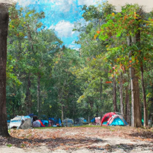
Oconee State Park campground
Community Reviews
Been here? Share the conditions.
Reviews, ratings & photos are added in the free Snoflo iOS app — rate a spot, tag the conditions, and your visit is verified by location. Add or manage your reviews from the app.
Oconee State Park
Reservations are accepted at Oconee State Park, ensuring campers can secure their preferred site in advance. It is advisable to make a reservation, especially during peak seasons, to guarantee availability. The best time to visit this camping area is during the spring and fall when the weather is mild and the park showcases its picturesque beauty. However, it is important to note that the campground remains open year-round, offering opportunities for camping in all seasons.
While exploring the camping area, visitors should be cautious of wildlife encounters and take necessary precautions to ensure their safety. It is recommended to store food securely and dispose of trash properly to avoid attracting animals. Furthermore, respecting the park's rules and regulations, such as observing quiet hours and practicing Leave No Trace principles, ensures a pleasant experience for all campers. With its amenities, reservation system, and natural attractions, Oconee State Park provides a wonderful camping destination for outdoor enthusiasts in South Carolina.
What's on-site at Oconee State Park
Key facilities Snoflo tracks for this campground. Confirm with the operator before booking -- amenities can change seasonally.
Plan your trip down to the hour
Same weather feed Snoflo's iOS app uses -- updated continuously from NOAA / yr.no.
Next 5 days, hour by hour
Temperature line with weather symbols on top, snow + rain accumulation as columns, humidity as a dotted line.
5-day forecast table
Every 3 hours, broken out across temperature, snow, rain, humidity, and wind. Each cell is colour-coded relative to the column min/max so trends jump out at a glance.
| Time | Condition | Temp (°F) | Snow (in) | Rain (in) | Humidity (%) | Wind (mps) | Wind dir |
|---|---|---|---|---|---|---|---|
| Loading detailed forecast… | |||||||
15-day temperature & precipitation
Daily temperatures, snow, and rain projected over the next two weeks. Hover any point for the full breakdown.
Other campgrounds in the area
Snoflo-tracked campsites within driving distance of Oconee State Park, with reservations status.
| Campground | Reservations | Toilets | View |
|---|---|---|---|
| Licklog Falls Campsite | ✗ | ✗ | → |
| Cherry Hill Recreation Area | ✓ | ✗ | → |
| Long Bottom Ford | ✗ | ✗ | → |
| Sandy Beach Campsite | ✗ | ✗ | → |
| Simms Field | ✗ | ✗ | → |
Nearby streamflow
USGS streamgauges within reach of Oconee State Park -- pulled live from the National Water Information System.
| Streamgauge | Discharge | View |
|---|---|---|
| Chattooga River Near Clayton | 301 cfs | → |
| Tallulah River Ab Powerhouse | 36 cfs | → |
| Twelvemile Creek Near Liberty | 60 cfs | → |
| Tallulah River Near Clayton | 78 cfs | → |
| French Broad River At Rosman | 97 cfs | → |
| Little Tennessee River Near Prentiss | 181 cfs | → |
Nearby snow depths
NRCS SNOTEL stations within reach of Oconee State Park -- relevant when planning a shoulder-season or alpine trip.
| SNOTEL station | Snowpack | 24h Snowfall | View |
|---|---|---|---|
| Dillard 0.7 Nnw | 0.0 in | 0.0 in | → |
| Germany Valley | 0.0 in | 0.0 in | → |
| Brevard | 0.0 in | 0.0 in | → |
| Anderson | 0.0 in | 0.0 in | → |
| Cleveland 3 S | 0.0 in | 0.0 in | → |
| Sautee 3.5 Sw | 0.0 in | 0.0 in | → |
Plan a longer trip
The closest parks, lakes, boat launches, and paddle runs so a camping night can grow into a full weekend.
Parks
- Oconee State Park
- Wilderness Ellicott Rock
- Devils Fork State Park
- Toxaway Game Land
- Keowee-Toxaway State Park
- South Cove County Park
Boat launches
- Stamp Creek
- Jocassee 1
- Jocassee 2
- Devils Fork Road Oconee County
- White Oak Hill Road Oconee County
- High Falls Road Oconee County
Fishing spots
Points of interest
- Station Cove Falls
- Yellow Branch Falls
- Oconee County Cage
- Spoonauger Falls
- Fall Creek Falls
- Riley Moore Falls
Paddle runs
- Headwaters Just East Of Hwy 107 To Crossing Of Norton Field Road (Fs 715a)
- Beginning Just Upstream Of Townes Creek,Wash Branch And Crane Creek To Confluence With Kings Creek
- Highway 28 To Earl's Ford (Section 2)
- Earl's Ford To Route 76 (Section 3)
- Burrels Ford To Lick Log Branch (Section 1)
- 1/4 Mile Below Walhalla Fish Hatchery To Boundary Of Chattooga Wsr
Camping essentials & Leave No Trace
- Pack it in, pack it out
- Take all trash, food scraps, and gear back with you to keep campsites clean and protect wildlife.
- Respect wildlife
- Observe animals from a distance, store food securely, and never feed wildlife to maintain natural behavior and safety.
- Know before you go
- Check weather, fire restrictions, trail conditions, and permit requirements to ensure a safe and well-planned trip.
- Minimize campfire impact
- Use established fire rings, keep fires small, fully extinguish them, or opt for a camp stove when fires are restricted.
- Leave what you find
- Preserve natural and cultural features by avoiding removal of plants, rocks, artifacts, or other elements of the environment.
Set push alerts in the Snoflo app
Save Oconee State Park as a favorite, set a custom threshold (precipitation, snowpack, freezing temperatures), and the iOS app will push the moment conditions cross.
About Oconee State Park
Can I make reservations at Oconee State Park?
Yes -- this campground accepts reservations. Snoflo recommends booking early for peak season; check the operator (Recreation.gov / state park system / private operator) for the booking window and cancellation policy.
How fresh is the weather data on this page?
The hourly forecast updates throughout the day from the NOAA / yr.no public feeds. Streamflow data is pulled live from USGS streamgauges and snowpack from the NRCS SNOTEL network.
What's the best time of year to visit?
Use the 15-day temperature & precipitation outlook on this page to plan -- pick a window with comfortable temperatures and low precipitation. For longer trips, the 5-day hourly meteogram shows snow + rain accumulation hour-by-hour.
How do I get to Oconee State Park?
Tap Directions in the hero above to open driving directions in Google Maps, or Open in map to center the Snoflo interactive map on the campground.
Can I get alerts when conditions change?
Yes -- alerts are managed through the Snoflo iOS app. Favorite this campground, set a threshold (temperature, snowpack, precipitation), and you'll get a push the moment it crosses.
Other campgrounds near here
Snoflo-tracked campgrounds within driving distance of Oconee State Park.