Indian Boundary Rec Area campground
Community Reviews
Been here? Share the conditions.
Reviews, ratings & photos are added in the free Snoflo iOS app — rate a spot, tag the conditions, and your visit is verified by location. Add or manage your reviews from the app.
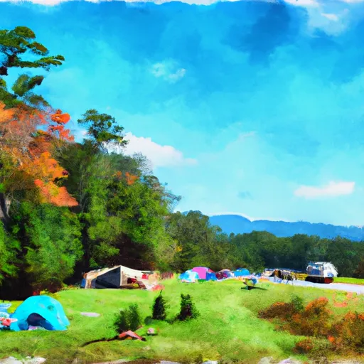
Indian Boundary Rec Area
Reservations are accepted at Indian Boundary Recreation Area, which is beneficial for those who prefer to plan their camping trips in advance. However, it's important to note that the campground can fill up quickly during peak season, so making a reservation is highly recommended.
The best time to visit Indian Boundary Recreation Area is during the spring and fall seasons when the weather is mild and pleasant. During these times, campers can enjoy activities such as fishing, swimming, hiking, and wildlife observation. It's worth noting that the campground is known for its beautiful lake, which offers opportunities for boating and fishing.
While exploring the camping area, campers should be cautious of poison ivy and ticks, which are common in the region. It's advisable to wear appropriate clothing and use insect repellent to minimize any potential risks. Overall, Indian Boundary Recreation Area is a wonderful camping destination that offers a variety of amenities, accepts reservations, and provides an array of outdoor activities for campers to enjoy.
What's on-site at Indian Boundary Rec Area
Key facilities Snoflo tracks for this campground. Confirm with the operator before booking -- amenities can change seasonally.
Plan your trip down to the hour
Same weather feed Snoflo's iOS app uses -- updated continuously from NOAA / yr.no.
Next 5 days, hour by hour
Temperature line with weather symbols on top, snow + rain accumulation as columns, humidity as a dotted line.
5-day forecast table
Every 3 hours, broken out across temperature, snow, rain, humidity, and wind. Each cell is colour-coded relative to the column min/max so trends jump out at a glance.
| Time | Condition | Temp (°F) | Snow (in) | Rain (in) | Humidity (%) | Wind (mps) | Wind dir |
|---|---|---|---|---|---|---|---|
| Loading detailed forecast… | |||||||
15-day temperature & precipitation
Daily temperatures, snow, and rain projected over the next two weeks. Hover any point for the full breakdown.
Other campgrounds in the area
Snoflo-tracked campsites within driving distance of Indian Boundary Rec Area, with reservations status.
| Campground | Reservations | Toilets | View |
|---|---|---|---|
| Indian Boundary Campground | ✗ | ✗ | → |
| Indian Boundary Overflow Campground | ✗ | ✗ | → |
| Indian Boundary Recreation Area | ✓ | ✗ | → |
| Double Camp/Citgo Creek | ✗ | ✗ | → |
| Jake Best Campground | ✗ | ✗ | → |
Nearby streamflow
USGS streamgauges within reach of Indian Boundary Rec Area -- pulled live from the National Water Information System.
| Streamgauge | Discharge | View |
|---|---|---|
| Tellico River At Tellico Plains | 301 cfs | → |
| Cheoah River Nr Bearpen Gap Nr Tapoco | 163 cfs | → |
| Valley River At Tomotla | 296 cfs | → |
| Little River Above Townsend | 312 cfs | → |
| Little River Near Maryville | 540 cfs | → |
| Little River Near Alcoa | 572 cfs | → |
Nearby snow depths
NRCS SNOTEL stations within reach of Indian Boundary Rec Area -- relevant when planning a shoulder-season or alpine trip.
| SNOTEL station | Snowpack | 24h Snowfall | View |
|---|---|---|---|
| Bryson City 4 | 0.0 in | 0.0 in | → |
| Gatlinburg | 0.0 in | 0.0 in | → |
| Kingston | 0.0 in | 0.0 in | → |
| New Found Gap | 0.5 in | 0.0 in | → |
| Dillard 0.7 Nnw | 0.0 in | 0.0 in | → |
Plan a longer trip
The closest parks, lakes, boat launches, and paddle runs so a camping night can grow into a full weekend.
Parks
- Wilderness Citico Creek
- Wilderness Bald River Gorge
- National Conservation Area Tellico Lake - Chota Unit
- Wilderness Joyce Kilmer-Slickrock
- Fort Loudoun State Recreation Area
- Tellico Blockhouse State Historic Site
Boat launches
- Indian Boundary Boat Ramp Monroe County
- Ballplay Boat Ramp
- Citico Boat Ramp
- Slickrock Creek Trail Monroe County
- Fairview Road 2418, Madisonville
- Tallassee
Fishing spots
Points of interest
Paddle runs
- Headwaters Near Graham County Line To Nc/Tn State Line
- Tn/Nc State Line (Rm 48.0) To Tn360 Bridge (Rm 30.0)
- Headwaters Near Mitchell Lick To Owlcamp Branch
- Owlcamp Branch To Polecat Branch
- Polecat Branch To Snowbird Picnic Area
- Apalachia Powerhouse (Rm 53.5) To Us411 Bridge (Rm 43.0)
Camping essentials & Leave No Trace
- Pack it in, pack it out
- Take all trash, food scraps, and gear back with you to keep campsites clean and protect wildlife.
- Respect wildlife
- Observe animals from a distance, store food securely, and never feed wildlife to maintain natural behavior and safety.
- Know before you go
- Check weather, fire restrictions, trail conditions, and permit requirements to ensure a safe and well-planned trip.
- Minimize campfire impact
- Use established fire rings, keep fires small, fully extinguish them, or opt for a camp stove when fires are restricted.
- Leave what you find
- Preserve natural and cultural features by avoiding removal of plants, rocks, artifacts, or other elements of the environment.
Set push alerts in the Snoflo app
Save Indian Boundary Rec Area as a favorite, set a custom threshold (precipitation, snowpack, freezing temperatures), and the iOS app will push the moment conditions cross.
About Indian Boundary Rec Area
Can I make reservations at Indian Boundary Rec Area?
Yes -- this campground accepts reservations. Snoflo recommends booking early for peak season; check the operator (Recreation.gov / state park system / private operator) for the booking window and cancellation policy.
How fresh is the weather data on this page?
The hourly forecast updates throughout the day from the NOAA / yr.no public feeds. Streamflow data is pulled live from USGS streamgauges and snowpack from the NRCS SNOTEL network.
What's the best time of year to visit?
Use the 15-day temperature & precipitation outlook on this page to plan -- pick a window with comfortable temperatures and low precipitation. For longer trips, the 5-day hourly meteogram shows snow + rain accumulation hour-by-hour.
How do I get to Indian Boundary Rec Area?
Tap Directions in the hero above to open driving directions in Google Maps, or Open in map to center the Snoflo interactive map on the campground.
Can I get alerts when conditions change?
Yes -- alerts are managed through the Snoflo iOS app. Favorite this campground, set a threshold (temperature, snowpack, precipitation), and you'll get a push the moment it crosses.
Other campgrounds near here
Snoflo-tracked campgrounds within driving distance of Indian Boundary Rec Area.