Watauga Dam Tailwater Campground
Community Reviews
Been here? Share the conditions.
Reviews, ratings & photos are added in the free Snoflo iOS app — rate a spot, tag the conditions, and your visit is verified by location. Add or manage your reviews from the app.
Watauga Dam Tailwater
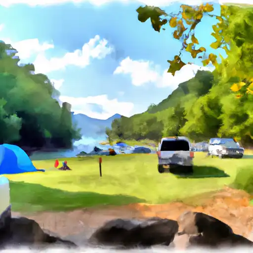
The campground offers amenities such as grills, picnic tables, fire rings, and modern restrooms. The campsites are available on a first-come, first-serve basis, and there are 28 sites available for tents and RVs. The area's unique feature is the two-mile-long tailwater stream, which flows directly below the dam and provides excellent trout fishing opportunities.
The best time to visit Watauga Dam Tailwater Camping Area is during the summer months from June to August when the temperature ranges from 70 to 85 degrees Fahrenheit. In the fall, the temperature ranges from 50 to 70 degrees Fahrenheit, providing ideal conditions for hiking and exploring the area's fall foliage.
An interesting fact about the area is that it's home to the Watauga River, which was named after the Cherokee word Watawah, meaning "beautiful waters." The river is known for its excellent trout fishing, and the surrounding area offers a variety of outdoor recreational activities for visitors.
What's on-site at Watauga Dam Tailwater
Key facilities Snoflo tracks for this campground. Confirm with the operator before booking -- amenities can change seasonally.
Plan your trip down to the hour
Same weather feed Snoflo's iOS app uses -- updated continuously from NOAA / yr.no.
Next 5 days, hour by hour
Temperature line with weather symbols on top, snow + rain accumulation as columns, humidity as a dotted line.
5-day forecast table
Every 3 hours, broken out across temperature, snow, rain, humidity, and wind. Each cell is colour-coded relative to the column min/max so trends jump out at a glance.
| Time | Condition | Temp (°F) | Snow (in) | Rain (in) | Humidity (%) | Wind (mps) | Wind dir |
|---|---|---|---|---|---|---|---|
| Loading detailed forecast… | |||||||
15-day temperature & precipitation
Daily temperatures, snow, and rain projected over the next two weeks. Hover any point for the full breakdown.
Other campgrounds in the area
Snoflo-tracked campsites within driving distance of Watauga Dam Tailwater, with reservations status.
| Campground | Reservations | Toilets | View |
|---|---|---|---|
| Cardens Bluff Campground | ✗ | ✗ | → |
| Cardens Bluff | ✗ | ✗ | → |
| Little Stoney Creek Campground | ✗ | ✗ | → |
| The Hamptons Rv Park | ✗ | ✗ | → |
| Dennis Cove Recreation Area | ✓ | ✗ | → |
Nearby streamflow
USGS streamgauges within reach of Watauga Dam Tailwater -- pulled live from the National Water Information System.
| Streamgauge | Discharge | View |
|---|---|---|
| Doe River At Elizabethton | 293 cfs | → |
| Watauga River At Elizabethton | 1,060 cfs | → |
| Watauga River Near Sugar Grove | 97 cfs | → |
| Beaver Creek At Bristol | 24 cfs | → |
| Nolichucky River At Embreeville | 2,020 cfs | → |
| S F Holston River Near Damascus | 368 cfs | → |
Nearby snow depths
NRCS SNOTEL stations within reach of Watauga Dam Tailwater -- relevant when planning a shoulder-season or alpine trip.
| SNOTEL station | Snowpack | 24h Snowfall | View |
|---|---|---|---|
| Elizabethton | 0.0 in | 0.0 in | → |
| Flat Springs 1e | 0.0 in | 0.0 in | → |
| Flat Springs 1.2 E | 0.0 in | 0.0 in | → |
| Vilas 6.3 Nnw | 0.0 in | 0.0 in | → |
| Beech Mountain | 0.0 in | 0.0 in | → |
| Banner Elk | 0.0 in | 0.0 in | → |
Plan a longer trip
The closest parks, lakes, boat launches, and paddle runs so a camping night can grow into a full weekend.
Parks
- Wilderness Big Laurel Brcanch
- Watauga Point Recreational Area
- Elizabethton City Park
- Elizabethton Historic District
- Walter Curtis Memorial Park
- Wilderness Pond Mountain
Boat launches
- Wilbur Dam Road Carter County
- Hunter Bridge
- Us 321;Sr 67 Carter County
- Watauga Lakeshores Marina
- Fish Springs Marina
- Cove Ridge Yacht Club And Marina
Fishing spots
Points of interest
- Wautauga Dam
- Elizabethton Covered Bridge
- Fort Watauga
- General Nathaniel Taylor House
- Rocky Mount State Historic Site
- The Warrior's Canvas & Veterans Art Center
Paddle runs
- Watauga Reservoir To Tn/Nc State Line
- Headwaters To Tn/Va State Line
- Tn/Nc State Line (Rm 100.6) To Mine Branch (Rm 99.3)
- Boundary Between Mitchell And Yancy Counties To Nc/Tn Stateline
- Headwaters Above Linville Gap To Blue Ridge Parkway Boundary
- Blue Ridge Parkway Boundary To Linville Gorge Boundary
Camping essentials & Leave No Trace
- Pack it in, pack it out
- Take all trash, food scraps, and gear back with you to keep campsites clean and protect wildlife.
- Respect wildlife
- Observe animals from a distance, store food securely, and never feed wildlife to maintain natural behavior and safety.
- Know before you go
- Check weather, fire restrictions, trail conditions, and permit requirements to ensure a safe and well-planned trip.
- Minimize campfire impact
- Use established fire rings, keep fires small, fully extinguish them, or opt for a camp stove when fires are restricted.
- Leave what you find
- Preserve natural and cultural features by avoiding removal of plants, rocks, artifacts, or other elements of the environment.
Set push alerts in the Snoflo app
Save Watauga Dam Tailwater as a favorite, set a custom threshold (precipitation, snowpack, freezing temperatures), and the iOS app will push the moment conditions cross.
About Watauga Dam Tailwater
Can I make reservations at Watauga Dam Tailwater?
This campground does not appear to accept reservations -- it's typically first-come, first-served. Arrive early on summer weekends.
How fresh is the weather data on this page?
The hourly forecast updates throughout the day from the NOAA / yr.no public feeds. Streamflow data is pulled live from USGS streamgauges and snowpack from the NRCS SNOTEL network.
What's the best time of year to visit?
Use the 15-day temperature & precipitation outlook on this page to plan -- pick a window with comfortable temperatures and low precipitation. For longer trips, the 5-day hourly meteogram shows snow + rain accumulation hour-by-hour.
How do I get to Watauga Dam Tailwater?
Tap Directions in the hero above to open driving directions in Google Maps, or Open in map to center the Snoflo interactive map on the campground.
Can I get alerts when conditions change?
Yes -- alerts are managed through the Snoflo iOS app. Favorite this campground, set a threshold (temperature, snowpack, precipitation), and you'll get a push the moment it crosses.
Other campgrounds near here
Snoflo-tracked campgrounds within driving distance of Watauga Dam Tailwater.