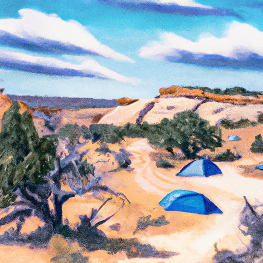
Turks Head Campground
Community Reviews
Been here? Share the conditions.
Reviews, ratings & photos are added in the free Snoflo iOS app — rate a spot, tag the conditions, and your visit is verified by location. Add or manage your reviews from the app.
Turks Head
Nearby points of interest include the Goblin Valley State Park, which is known for its unique rock formations that resemble goblins. The Little Wild Horse Canyon is also nearby and is a popular hiking destination for its narrow canyon walls and slot canyons.
The Turks Head camping area provides basic amenities for campers, including a vault toilet and fire rings. However, there is no potable water available, so visitors should bring their own. Camping is available on a first-come, first-served basis, and there is no fee to camp.
Interesting facts about the area include that the San Rafael Swell was once covered by an ocean and is now a desert landscape. The area is also home to dinosaur fossils and petroglyphs left by ancient civilizations.
The best time to visit the Turks Head camping area is in the spring or fall when temperatures are milder. Average temperatures in the spring (March to May) range from 40-70 degrees Fahrenheit, and in the fall (September to November) range from 40-80 degrees Fahrenheit. It is not recommended to visit during the summer months due to high temperatures, which can exceed 100 degrees Fahrenheit.
Overall, the Turks Head camping area offers a unique camping experience in a stunning desert landscape with nearby points of interest and interesting historical and geological features.
What's on-site at Turks Head
Key facilities Snoflo tracks for this campground. Confirm with the operator before booking -- amenities can change seasonally.
Plan your trip down to the hour
Same weather feed Snoflo's iOS app uses -- updated continuously from NOAA / yr.no.
Next 5 days, hour by hour
Temperature line with weather symbols on top, snow + rain accumulation as columns, humidity as a dotted line.
5-day forecast table
Every 3 hours, broken out across temperature, snow, rain, humidity, and wind. Each cell is colour-coded relative to the column min/max so trends jump out at a glance.
| Time | Condition | Temp (°F) | Snow (in) | Rain (in) | Humidity (%) | Wind (mps) | Wind dir |
|---|---|---|---|---|---|---|---|
| Loading detailed forecast… | |||||||
15-day temperature & precipitation
Daily temperatures, snow, and rain projected over the next two weeks. Hover any point for the full breakdown.
Other campgrounds in the area
Snoflo-tracked campsites within driving distance of Turks Head, with reservations status.
| Campground | Reservations | Toilets | View |
|---|---|---|---|
| Candlestick | ✗ | ✗ | → |
| Dead Horse | ✗ | ✗ | → |
| Murphy Hogback C | ✗ | ✗ | → |
| Murphy Hogback B | ✗ | ✗ | → |
| Murphy Hogback A | ✗ | ✗ | → |
Nearby streamflow
USGS streamgauges within reach of Turks Head -- pulled live from the National Water Information System.
| Streamgauge | Discharge | View |
|---|---|---|
| Green River At Mineral Bottom Nr Cynlnds Ntl Park | 1,840 cfs | → |
| Colorado River At Potash | 1,630 cfs | → |
| Mill Creek Blw Pack Creek Nr Mouth At Moab | 1 cfs | → |
| San Rafael River At Mouth Near Green River | · | → |
| Mill Creek Below Sheley Tunnel | 3 cfs | → |
| Mill Creek At Sheley Tunnel | 3 cfs | → |
Nearby snow depths
NRCS SNOTEL stations within reach of Turks Head -- relevant when planning a shoulder-season or alpine trip.
| SNOTEL station | Snowpack | 24h Snowfall | View |
|---|---|---|---|
| Hams Flat Rs | 0.0 in | 0.0 in | → |
| Canyonlands-The Needles | 0.0 in | 0.0 in | → |
| Arches Np Hqs Coop | 0.0 in | 0.0 in | → |
| Castle Valley 1se | 0.0 in | 0.0 in | → |
| Lasal Mountain-Lower | 0.0 in | 0.0 in | → |
| Lasal Mountain-Lower | 0.0 in | 0.0 in | → |
Plan a longer trip
The closest parks, lakes, boat launches, and paddle runs so a camping night can grow into a full weekend.
Parks
- Dead Horse Point State Park
- Swanny City Park
- Sand Flats Recreation Area
- Old City Park
- Arches National Park
- Canyonlands National Park
Boat launches
Fishing spots
Points of interest
Camping essentials & Leave No Trace
- Pack it in, pack it out
- Take all trash, food scraps, and gear back with you to keep campsites clean and protect wildlife.
- Respect wildlife
- Observe animals from a distance, store food securely, and never feed wildlife to maintain natural behavior and safety.
- Know before you go
- Check weather, fire restrictions, trail conditions, and permit requirements to ensure a safe and well-planned trip.
- Minimize campfire impact
- Use established fire rings, keep fires small, fully extinguish them, or opt for a camp stove when fires are restricted.
- Leave what you find
- Preserve natural and cultural features by avoiding removal of plants, rocks, artifacts, or other elements of the environment.
Set push alerts in the Snoflo app
Save Turks Head as a favorite, set a custom threshold (precipitation, snowpack, freezing temperatures), and the iOS app will push the moment conditions cross.
About Turks Head
Can I make reservations at Turks Head?
This campground does not appear to accept reservations -- it's typically first-come, first-served. Arrive early on summer weekends.
How fresh is the weather data on this page?
The hourly forecast updates throughout the day from the NOAA / yr.no public feeds. Streamflow data is pulled live from USGS streamgauges and snowpack from the NRCS SNOTEL network.
What's the best time of year to visit?
Use the 15-day temperature & precipitation outlook on this page to plan -- pick a window with comfortable temperatures and low precipitation. For longer trips, the 5-day hourly meteogram shows snow + rain accumulation hour-by-hour.
How do I get to Turks Head?
Tap Directions in the hero above to open driving directions in Google Maps, or Open in map to center the Snoflo interactive map on the campground.
Can I get alerts when conditions change?
Yes -- alerts are managed through the Snoflo iOS app. Favorite this campground, set a threshold (temperature, snowpack, precipitation), and you'll get a push the moment it crosses.
Other campgrounds near here
Snoflo-tracked campgrounds within driving distance of Turks Head.