Deschutes River State Rec Area Campground
Community Reviews
Been here? Share the conditions.
Reviews, ratings & photos are added in the free Snoflo iOS app — rate a spot, tag the conditions, and your visit is verified by location. Add or manage your reviews from the app.
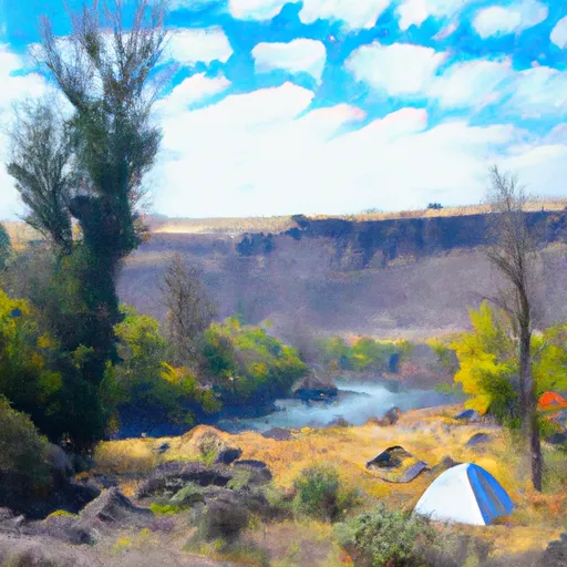
Deschutes River State Rec Area
Reservations are accepted at the Deschutes River State Recreation Area, allowing campers to secure their spot in advance. This is especially recommended during peak seasons when the campground tends to fill up quickly. The best time to visit the area is during spring and fall when the weather is mild, and the crowds are smaller. The summer months also attract visitors, but it can get quite hot, so be prepared for high temperatures.
While camping at Deschutes River State Recreation Area, there are several nearby attractions worth exploring. The park provides access to various hiking trails, fishing spots, and opportunities for wildlife viewing. The Deschutes River offers excellent fishing for steelhead and trout, making it a favorite among anglers. It is important to be cautious when camping near the river, as water levels can rise rapidly during heavy rain or spring snowmelt. Additionally, ticks and poison oak are present in the area, so visitors should be aware and take precautions. Overall, Deschutes River State Recreation Area offers a tranquil setting for camping and outdoor activities, providing a memorable experience for nature enthusiasts.
What's on-site at Deschutes River State Rec Area
Key facilities Snoflo tracks for this campground. Confirm with the operator before booking -- amenities can change seasonally.
Plan your trip down to the hour
Same weather feed Snoflo's iOS app uses -- updated continuously from NOAA / yr.no.
Next 5 days, hour by hour
Temperature line with weather symbols on top, snow + rain accumulation as columns, humidity as a dotted line.
5-day forecast table
Every 3 hours, broken out across temperature, snow, rain, humidity, and wind. Each cell is colour-coded relative to the column min/max so trends jump out at a glance.
| Time | Condition | Temp (°F) | Snow (in) | Rain (in) | Humidity (%) | Wind (mps) | Wind dir |
|---|---|---|---|---|---|---|---|
| Loading detailed forecast… | |||||||
15-day temperature & precipitation
Daily temperatures, snow, and rain projected over the next two weeks. Hover any point for the full breakdown.
Nearby streamflow
USGS streamgauges within reach of Deschutes River State Rec Area -- pulled live from the National Water Information System.
| Streamgauge | Discharge | View |
|---|---|---|
| Deschutes River At Moody | 3,920 cfs | → |
| Columbia River At The Dalles | 126,000 cfs | → |
| Klickitat River Near Pitt | 759 cfs | → |
| Mosier Creek Near Mosier | 1 cfs | → |
| John Day River At Mcdonald Ferry | 52 cfs | → |
| Klickitat River Bl Summit Creek Near Glenwood | 1,820 cfs | → |
Nearby snow depths
NRCS SNOTEL stations within reach of Deschutes River State Rec Area -- relevant when planning a shoulder-season or alpine trip.
| SNOTEL station | Snowpack | 24h Snowfall | View |
|---|---|---|---|
| Snowden | 0.0 in | 0.0 in | → |
| Nohrsc Indian Rock | 0.0 in | 0.0 in | → |
| Indian Rock | 0.0 in | 0.0 in | → |
| 20d01 - Satus Pass | 0.0 in | 0.0 in | → |
| Satus Pass | 0.0 in | 0.0 in | → |
| Hood River | 0.0 in | 0.0 in | → |
Plan a longer trip
The closest parks, lakes, boat launches, and paddle runs so a camping night can grow into a full weekend.
Parks
- Deschutes River State Recreation Area
- Celilo Park
- Maryhill State Park
- Columbia Hills Natural Area Preserve
- Horsethief Lake State Park
- Sorosis Park
Boat launches
- Heritage Landing State Park
- Heritage Landing
- Celilo Park
- Maryhill State Park
- Avery Park
- Lewis And Clark Trail Highway Dallesport
Camping essentials & Leave No Trace
- Pack it in, pack it out
- Take all trash, food scraps, and gear back with you to keep campsites clean and protect wildlife.
- Respect wildlife
- Observe animals from a distance, store food securely, and never feed wildlife to maintain natural behavior and safety.
- Know before you go
- Check weather, fire restrictions, trail conditions, and permit requirements to ensure a safe and well-planned trip.
- Minimize campfire impact
- Use established fire rings, keep fires small, fully extinguish them, or opt for a camp stove when fires are restricted.
- Leave what you find
- Preserve natural and cultural features by avoiding removal of plants, rocks, artifacts, or other elements of the environment.
Set push alerts in the Snoflo app
Save Deschutes River State Rec Area as a favorite, set a custom threshold (precipitation, snowpack, freezing temperatures), and the iOS app will push the moment conditions cross.
About Deschutes River State Rec Area
Can I make reservations at Deschutes River State Rec Area?
Yes -- this campground accepts reservations. Snoflo recommends booking early for peak season; check the operator (Recreation.gov / state park system / private operator) for the booking window and cancellation policy.
How fresh is the weather data on this page?
The hourly forecast updates throughout the day from the NOAA / yr.no public feeds. Streamflow data is pulled live from USGS streamgauges and snowpack from the NRCS SNOTEL network.
What's the best time of year to visit?
Use the 15-day temperature & precipitation outlook on this page to plan -- pick a window with comfortable temperatures and low precipitation. For longer trips, the 5-day hourly meteogram shows snow + rain accumulation hour-by-hour.
How do I get to Deschutes River State Rec Area?
Tap Directions in the hero above to open driving directions in Google Maps, or Open in map to center the Snoflo interactive map on the campground.
Can I get alerts when conditions change?
Yes -- alerts are managed through the Snoflo iOS app. Favorite this campground, set a threshold (temperature, snowpack, precipitation), and you'll get a push the moment it crosses.
Other campgrounds near here
Snoflo-tracked campgrounds within driving distance of Deschutes River State Rec Area.