Thornton Lake Campground
Community Reviews
Been here? Share the conditions.
Reviews, ratings & photos are added in the free Snoflo iOS app — rate a spot, tag the conditions, and your visit is verified by location. Add or manage your reviews from the app.
Thornton Lake
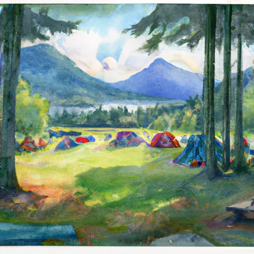
The campground provides basic amenities such as restrooms, picnic tables, and fire pits. However, there is no potable water available on-site and campers must bring their own. The campground operates on a first-come, first-served basis and has ten campsites available for tent camping.
An interesting fact about the Thornton Lake Camping Area is that the lake is actually man-made, created in the 1960s as part of a hydroelectric project. However, the area now serves as a popular recreational destination for hikers and campers.
The best time to visit Thornton Lake Camping Area is between June and September, when temperatures range from 50-70 degrees Fahrenheit. Visitors should note that the campground is only accessible via a steep 2.5-mile gravel road, which may be difficult for some vehicles to navigate. However, those who make the journey will be rewarded with stunning views and a peaceful retreat in the heart of the mountains.
What's on-site at Thornton Lake
Key facilities Snoflo tracks for this campground. Confirm with the operator before booking -- amenities can change seasonally.
Plan your trip down to the hour
Same weather feed Snoflo's iOS app uses -- updated continuously from NOAA / yr.no.
Next 5 days, hour by hour
Temperature line with weather symbols on top, snow + rain accumulation as columns, humidity as a dotted line.
5-day forecast table
Every 3 hours, broken out across temperature, snow, rain, humidity, and wind. Each cell is colour-coded relative to the column min/max so trends jump out at a glance.
| Time | Condition | Temp (°F) | Snow (in) | Rain (in) | Humidity (%) | Wind (mps) | Wind dir |
|---|---|---|---|---|---|---|---|
| Loading detailed forecast… | |||||||
15-day temperature & precipitation
Daily temperatures, snow, and rain projected over the next two weeks. Hover any point for the full breakdown.
Other campgrounds in the area
Snoflo-tracked campsites within driving distance of Thornton Lake, with reservations status.
| Campground | Reservations | Toilets | View |
|---|---|---|---|
| Lower Goodell Crek Campground | ✗ | ✗ | → |
| Lower Goodell Creek Group Campground | ✗ | ✗ | → |
| Upper Goodell Creek Group Campground | ✗ | ✗ | → |
| Goodell Creek Campground | ✗ | ✗ | → |
| Goodell Creek - North Cascades | ✗ | ✗ | → |
Nearby streamflow
USGS streamgauges within reach of Thornton Lake -- pulled live from the National Water Information System.
| Streamgauge | Discharge | View |
|---|---|---|
| Skagit River At Newhalem | 3,290 cfs | → |
| Newhalem Creek Near Newhalem | 32 cfs | → |
| Bacon Creek Below Oakes Creek Near Marblemount | 109 cfs | → |
| Skagit River At Marblemount | 3,470 cfs | → |
| Cascade River At Marblemount | 431 cfs | → |
| Thunder Creek Near Newhalem | 677 cfs | → |
Nearby snow depths
NRCS SNOTEL stations within reach of Thornton Lake -- relevant when planning a shoulder-season or alpine trip.
| SNOTEL station | Snowpack | 24h Snowfall | View |
|---|---|---|---|
| Newhalem | 0.0 in | 0.0 in | → |
| Diablo Reservoir | 0.0 in | 0.0 in | → |
| Diablo Dam | 0.0 in | 0.0 in | → |
| Nohrsc 21a07 - Easy Pass Am | 0.0 in | 0.0 in | → |
| Easy Pass | 0.0 in | 0.0 in | → |
| Nohrsc Beaver Pass | 0.0 in | 0.0 in | → |
Plan a longer trip
The closest parks, lakes, boat launches, and paddle runs so a camping night can grow into a full weekend.
Parks
- Ross Lake National Recreation Area
- Wilderness Noisy-Diobsud
- Rockport State Park
- Upper Skagit Garden Club Park
- Mount Baker National Recreation Area
- Wilderness Mount Baker
Boat launches
- Colonial Creek Campground
- Marblemount Boat Launch
- National Forest Development Road 1150 Whatcom County
- National Forest Development Road 1142 Whatcom County
- National Forest Development Road 11, Concrete
- National Forest Development Road 012 Whatcom County
Points of interest
- "Old Number 6" Seattle City Light Locomotive
- Gorge Powerhouse Visitor Gallery
- Sourdough Mountain Lookout
- Copper Mountain Fire Lookout
- Rock Cabin
- Shadow Of The Sentinels
Paddle runs
- Upper Goodell Campground (Rm 0.5) To Confluence With Skagit River
- Begins Upstream Of The Diversion Dam (Rm 1) To Confluence With Skagit River
- Begins Below Gorge Powerhouse To Ross Lake National Recreation Area Boundary
- Headwaters In Se1/4 Of Sec 36, T37n, R9e To South Section Line Of Sec 24, T36n, R10e
- Headwaters To Upper Goodell Campground (Rm 0.5)
- South Section Line Of Sec 24, T36n, R10e To Confluence With Skagit River
Camping essentials & Leave No Trace
- Pack it in, pack it out
- Take all trash, food scraps, and gear back with you to keep campsites clean and protect wildlife.
- Respect wildlife
- Observe animals from a distance, store food securely, and never feed wildlife to maintain natural behavior and safety.
- Know before you go
- Check weather, fire restrictions, trail conditions, and permit requirements to ensure a safe and well-planned trip.
- Minimize campfire impact
- Use established fire rings, keep fires small, fully extinguish them, or opt for a camp stove when fires are restricted.
- Leave what you find
- Preserve natural and cultural features by avoiding removal of plants, rocks, artifacts, or other elements of the environment.
Set push alerts in the Snoflo app
Save Thornton Lake as a favorite, set a custom threshold (precipitation, snowpack, freezing temperatures), and the iOS app will push the moment conditions cross.
About Thornton Lake
Can I make reservations at Thornton Lake?
This campground does not appear to accept reservations -- it's typically first-come, first-served. Arrive early on summer weekends.
How fresh is the weather data on this page?
The hourly forecast updates throughout the day from the NOAA / yr.no public feeds. Streamflow data is pulled live from USGS streamgauges and snowpack from the NRCS SNOTEL network.
What's the best time of year to visit?
Use the 15-day temperature & precipitation outlook on this page to plan -- pick a window with comfortable temperatures and low precipitation. For longer trips, the 5-day hourly meteogram shows snow + rain accumulation hour-by-hour.
How do I get to Thornton Lake?
Tap Directions in the hero above to open driving directions in Google Maps, or Open in map to center the Snoflo interactive map on the campground.
Can I get alerts when conditions change?
Yes -- alerts are managed through the Snoflo iOS app. Favorite this campground, set a threshold (temperature, snowpack, precipitation), and you'll get a push the moment it crosses.
Other campgrounds near here
Snoflo-tracked campgrounds within driving distance of Thornton Lake.